Dunmovin, California
| Dunmovin | |
|---|---|
| Unincorporated community | |
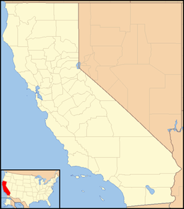 Dunmovin  Dunmovin Location in California | |
| Coordinates: 36°05′19″N 117°57′40″W / 36.08861°N 117.96111°WCoordinates: 36°05′19″N 117°57′40″W / 36.08861°N 117.96111°W | |
| Country | United States |
| State | California |
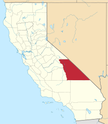
| County | Inyo County |
| Elevation[1] | 3,507 ft (1,069 m) |
Dunmovin (formerly, Cowan Station)[2] is an unincorporated community in Inyo County, California.[1] It is located 4.8 km (3 mi) north of Coso Junction and 21.6 km (13.5 mi) south-southeast of Olancha, at an elevation of 3507 feet (1069 m).[1]
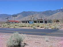
Ruins of Dunmovin
A post office operated at Dunmovin from 1938 to 1941.[2] The place was originally called Cowan Station in honor of homesteader James Cowan.[2] Cowan Station was a freight station for silver ingots being transported from the Cerro Gordo Mines to Los Angeles. When Cowan sold out in 1936, the name was changed to Dunmovin.[2] It was a roadside service station, cafe, and store along U.S. Route 395.
Dunmovin has been noted for its unusual place name.[3]
References
- 1 2 3 U.S. Geological Survey Geographic Names Information System: Dunmovin, California
- 1 2 3 4 Durham, David L. (1998). California's Geographic Names: A Gazetteer of Historic and Modern Names of the State. Clovis, Calif.: Word Dancer Press. p. 1162. ISBN 1-884995-14-4.
- ↑ Thompson, George E. (1 July 2009). You Live Where?: Interesting and Unusual Facts about where We Live. iUniverse. p. 10. ISBN 978-1-4401-3421-0.
This article is issued from Wikipedia - version of the 9/27/2016. The text is available under the Creative Commons Attribution/Share Alike but additional terms may apply for the media files.