Baie-Obaoca, Quebec
| Baie-Obaoca | |
|---|---|
| Unorganized territory | |
 Location within Matawinie RCM. | |
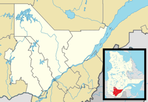 Baie-Obaoca Location in central Quebec. | |
| Coordinates: 47°31′N 74°18′W / 47.517°N 74.300°WCoordinates: 47°31′N 74°18′W / 47.517°N 74.300°W[1] | |
| Country |
|
| Province |
|
| Region | Lanaudière |
| RCM | Matawinie |
| Constituted | March 13, 1986 |
| Government[2] | |
| • Federal riding | Joliette |
| • Prov. riding | Berthier |
| Area[2][3] | |
| • Total | 1,479.61 km2 (571.28 sq mi) |
| • Land | 1,280.59 km2 (494.44 sq mi) |
| Population (2011)[3] | |
| • Total | 0 |
| • Density | 0.0/km2 (0/sq mi) |
| • Pop 2006-2011 |
|
| • Dwellings | 0 |
| Time zone | EST (UTC−5) |
| • Summer (DST) | EDT (UTC−4) |
| Highways | No major routes |
Bay Obaoca is an unorganized territory forming part of the Matawinie Regional County Municipality which is part of the administrative region of Lanaudière, in Quebec, in Canada.[4]
Toponymy
His name was formalized on March 13, 1986 in the Bank of place names of Commission de toponymie du Québec (Geographical Names Board of Québec).[5] It takes its name from the Obaoca Bay, located north-west end of Kempt Lake (Matawinie).[6]
Geography
This unorganized territory covers an area of 1,278.22 square kilometres (493.52 sq mi).[7]
See also
References
- ↑ Reference number 149655 of the Commission de toponymie du Québec (French)
- 1 2 Geographic code 62918 in the official Répertoire des municipalités (French)
- 1 2 Statistics Canada 2011 Census - Baie-Obaoca census profile
- ↑ Government of Quebec. "Bay Obaoca". Ministry of Municipal Affairs, Regions and land Occupancy. Municipal Directory.
- ↑ Commission de toponymie du Québec - Toponymy: Bay Obaoca
- ↑ Commission de toponymie du Québec - Toponymy:Bay Obaoca
- ↑ Statistics Canada: Baie-Obaoca
 |
Lac-Bazinet | La Tuque | | |
| Lac-Cabasta / Baie-Atibenne |
|
|||
| ||||
| | ||||
| Baie-de-la-Bouteille | Rivière-de-la-Savane | Lac-Normand |
| Municipalities | |
|---|---|
| Parishes | |
| Unorganized Territories | |
| |
This article is issued from Wikipedia - version of the 5/27/2015. The text is available under the Creative Commons Attribution/Share Alike but additional terms may apply for the media files.