Arago, Oregon
| Arago, Oregon | |
|---|---|
| Unincorporated community | |
 Arago  Arago Location within the state of Oregon | |
| Coordinates: 43°06′07″N 124°11′32″W / 43.10194°N 124.19222°WCoordinates: 43°06′07″N 124°11′32″W / 43.10194°N 124.19222°W | |
| Country | United States |
| State | Oregon |
| County | Coos |
| Elevation[1] | 30 ft (9 m) |
| Time zone | Pacific (PST) (UTC-8) |
| • Summer (DST) | PDT (UTC-7) |
| GNIS feature ID | 1117024 |
Arago is an unincorporated community in Coos County, Oregon, on the Coquille River, about 6 miles (10 km) south of Coquille. The area's elevation is 30 feet (9 m).[1] The Coquille Rural Fire District provides firefighting services.[2] The Coos County Sheriff and Myrtle Point police provide law enforcement services.
History
The Arago post office was named for Cape Arago, which in turn was named for French physicist and geographer François Arago.[3] The previously suggested name of Halls Prairie was disapproved by postal authorities.[3]
References
- 1 2 "Arago". Geographic Names Information System (GNIS). United States Geological Survey. November 28, 1980. Retrieved May 4, 2016.
- ↑ "Coquille Fire Department". City of Coquille. Retrieved May 4, 2016.
- 1 2 McArthur, Lewis A.; Lewis L. McArthur (2003) [1928]. Oregon Geographic Names (Seventh ed.). Portland, Oregon: Oregon Historical Society Press. pp. 29, 159. ISBN 0-87595-277-1.
Municipalities and communities of Coos County, Oregon, United States | ||
|---|---|---|
| Cities | 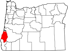 | |
| CDPs | ||
| Unincorporated communities | ||
| Ghost town | ||
This article is issued from Wikipedia - version of the 7/30/2016. The text is available under the Creative Commons Attribution/Share Alike but additional terms may apply for the media files.