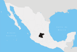
Yuriria
Yuririhapundaro, Guanajuato, Mexico, also known as Yuriria (Spanish ![]() ), is one of 46 municipalities in the Mexican state of Guanajuato.
), is one of 46 municipalities in the Mexican state of Guanajuato.
Name
The name Yuririhapundaro comes from the purepecha idiom and means Place of the Bloody Lake.
Town facts
Location and size
Yuriria is located in the "Bajío", or lowlands, of Guanajuato. It is bordered to the east by Salvatierra and Santiago Maravatío, to the north by Jaral del Progreso and Valle de Santiago, to the south by Uriangato and Moroleón, and to the west by the state of Michoacán. Its total area is 656 kilometres².
Population
The population of Yuriria and its surrounding areas totals 89,126 people. Of these, only 26,337 live in urban Yuriria, while 62,789 live in the rural areas surrounding the main town. The largest rural municipalities in Yuriria are [[Cerano]pop7,796.] El Monte de los Juarez, its main agricultural source with population of approximately(pop.1,589), El Xoconostle (pop. 1,200), La Calera (pop. 3,896) and Casacuarán (pop. 3,398). Santa Monica Ozumbilla is one of the oldest communities in Yuriria dating as far back as the early 16th century.
Town icons
Yuriria has many structural, as well as geographical icons, that throughout the years have become major sight locations in the state of Guanajuato. Some of these include:
Ex-Convento
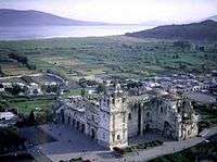
The Ex-Covento, or cathedral is probably the most important architectural structure in Yuriria, as well as an important icon in the state in general. Since its construction in November 1550, and its culmination on 1559, its massive size and dazzling structure captured the attention of generations, and ultimately put Yuriria on the map. Its construction was started by Fray Diego de Chavez, nephew of the conquistador Don Pedro Alvarado and was designed by the famous architect Pedro del Toro.
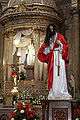
Preciosa Sangre de Cristo
 Detail of the Temple of the Ex-Convent of San Agustín de Yuriria.
 Detail of the Temple of the Ex-Convent of San Agustín de Yuriria.
 Detail of the Temple of the Ex-Convent of San Agustín de Yuriria.
 Interior view of Yuriria Convent.
Climate
| Climate data for Yuriria | |||||||||||||
|---|---|---|---|---|---|---|---|---|---|---|---|---|---|
| Month | Jan | Feb | Mar | Apr | May | Jun | Jul | Aug | Sep | Oct | Nov | Dec | Year |
| Average high °C (°F) | 23.1 (73.6) |
25 (77) |
27.7 (81.9) |
29.9 (85.8) |
31 (87.8) |
29.2 (84.6) |
27.1 (80.8) |
26.7 (80.1) |
25.9 (78.6) |
25.2 (77.4) |
24.4 (75.9) |
23.1 (73.6) |
26.5 (79.7) |
| Average low °C (°F) | 6.6 (43.9) |
7.6 (45.7) |
10.1 (50.2) |
12.5 (54.5) |
14.7 (58.5) |
15.5 (59.9) |
14.7 (58.5) |
14.6 (58.3) |
14.4 (57.9) |
12 (53.6) |
9 (48.2) |
7 (45) |
11.6 (52.9) |
| Average precipitation mm (inches) | 13 (0.5) |
8 (0.3) |
8 (0.3) |
10 (0.4) |
30 (1.2) |
119 (4.7) |
150 (6) |
155 (6.1) |
117 (4.6) |
46 (1.8) |
13 (0.5) |
8 (0.3) |
673 (26.5) |
| Source: Weatherbase [1] | |||||||||||||
External links
References
- ↑ "Weatherbase: Historical Weather for Yuriria, Guanajuato". Weatherbase. 2011. Retrieved on November 24, 2011.
Coordinates: 20°12′N 101°09′W / 20.200°N 101.150°W