Celaya
| Celaya | ||
|---|---|---|
| ||
| Motto: "De Forti Dulcedo" (La Dulzura del Fuerte) (The Sweetness of the Fort) | ||
|
Celaya | ||
| Coordinates: 20°31′23″N 100°48′50″W / 20.52306°N 100.81389°W | ||
| Country |
| |
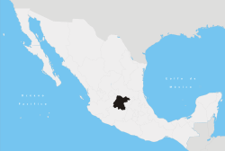
| State | Guanajuato | |
| Municipality | Celaya | |
| Foundation | October 12, 1570 | |
| Founded by | Martín Enríquez de Almanza | |
| Government | ||
| • Mayor | Ismael Pérez Ordaz (PAN), 2012-2015 | |
| Area | ||
| • Total | 553.18 km2 (213.58 sq mi) | |
| Elevation | 1,767 m (5,797 ft) | |
| Population (2012) | ||
| • Total | 468,469 | |
| • Density | 850/km2 (2,200/sq mi) | |
| Time zone | Central Standard Time (UTC-6) | |
| • Summer (DST) | Central Daylight Time (UTC-5) | |
| Postal code | 38000 - 38159 | |
| Area code(s) | 461 | |
| Airport | Aeropuerto Nacional Capitán Rogelio Castillo | |
| Website | http://www.celaya.gob.mx | |
Celaya is a city and its surrounding municipality in the state of Guanajuato, Mexico, located in the southeast quadrant of the state. It is the third most populous city in the state, with a 2005 census population of 310,413. The municipality for which the city serves as municipal seat, had a population of 415,869. The city is located in the geographic center of the municipality, which has an areal extent of 553.18 km² (213.58 sq mi) and includes many smaller outlying communities, the largest of which are San Miguel Octopan, Rincón de Tamayo and San Juan de la Vega.
There are many smaller towns around Celaya including Rincón de Tamayo, Tarimoro, Salvatierra, La Moncada, Panales Jamaica (Cañones), Panales Galera, La Calera, La Estancia, La Noria, La Acebuche, Cacalote, and Charco Largo.
General Álvaro Obregón defeated Pancho Villa in the Battle of Celaya, 1915. Celaya was also the Guanajuato state capital for a short period.
An explosion in a gunpowder and fireworks warehouse in September, 1999, killed over 60 people and injured over 300 people. [1][2]
Celaya is also famous for the artisanal production of cajeta, a type of milk candy
The Celaya Airport has as of January 22, 2007 commercial flights to Santiago de Querétaro and connections from there to other destinations. Celaya lies along the Pan-American Highway which is known locally as Mexican Federal Highway 45.
History

_Vendedores_ambulantes_en_la_estaci%C3%B3n_de_tren_en_Celaya..jpeg)
Celaya was a frontier region between the Purépecha and the Chichimecas.[3]
Climate
| Climate data for Celaya | |||||||||||||
|---|---|---|---|---|---|---|---|---|---|---|---|---|---|
| Month | Jan | Feb | Mar | Apr | May | Jun | Jul | Aug | Sep | Oct | Nov | Dec | Year |
| Record high °C (°F) | 36.0 (96.8) |
33.0 (91.4) |
39.0 (102.2) |
39.0 (102.2) |
38.5 (101.3) |
38.0 (100.4) |
33.5 (92.3) |
33.0 (91.4) |
33.0 (91.4) |
34.0 (93.2) |
35.0 (95) |
34.0 (93.2) |
39 (102.2) |
| Average high °C (°F) | 24.7 (76.5) |
26.1 (79) |
28.5 (83.3) |
30.2 (86.4) |
31.3 (88.3) |
29.4 (84.9) |
27.3 (81.1) |
27.4 (81.3) |
27.1 (80.8) |
26.7 (80.1) |
26.5 (79.7) |
25.3 (77.5) |
27.5 (81.5) |
| Daily mean °C (°F) | 15.1 (59.2) |
16.2 (61.2) |
18.5 (65.3) |
20.6 (69.1) |
22.4 (72.3) |
22.1 (71.8) |
20.8 (69.4) |
20.7 (69.3) |
20.4 (68.7) |
19.0 (66.2) |
17.6 (63.7) |
16.2 (61.2) |
19.1 (66.4) |
| Average low °C (°F) | 5.5 (41.9) |
6.4 (43.5) |
8.4 (47.1) |
11.0 (51.8) |
13.6 (56.5) |
14.9 (58.8) |
14.3 (57.7) |
14.0 (57.2) |
13.6 (56.5) |
11.4 (52.5) |
8.7 (47.7) |
7.0 (44.6) |
10.7 (51.3) |
| Record low °C (°F) | −3.5 (25.7) |
−3.5 (25.7) |
−3.0 (26.6) |
1.0 (33.8) |
6.0 (42.8) |
7.0 (44.6) |
8.5 (47.3) |
6.5 (43.7) |
3.0 (37.4) |
3.5 (38.3) |
−1.5 (29.3) |
−3.5 (25.7) |
−3.5 (25.7) |
| Average precipitation mm (inches) | 12.5 (0.492) |
5.7 (0.224) |
8.5 (0.335) |
14.6 (0.575) |
31.0 (1.22) |
97.5 (3.839) |
140.6 (5.535) |
120.7 (4.752) |
94.3 (3.713) |
36.3 (1.429) |
14.5 (0.571) |
8.8 (0.346) |
585.0 (23.031) |
| Average precipitation days (≥ 0.1 mm) | 2.2 | 1.2 | 1.5 | 2.5 | 5.3 | 10.7 | 13.8 | 12.8 | 9.8 | 4.9 | 2.2 | 1.8 | 68.7 |
| Source: Servicio Meteorologico Nacional[4] | |||||||||||||
Ball of Water

The Ball of Water reservoir has been a city icon since 1908; it continues to supply water to portions of downtown. The tank was manufactured in Germany and assembled on site, and is unique in being assembled using rivets rather than welds. It is believed to be the only one of its kind with a spherical shape (it is rumored that there was another similar water ball in Stuttgart, Germany that was destroyed during the Second World War). Traditionally, locals tell visitors that it is filled with cajeta, taking them to visit the "Bola del Agua" on Sundays, the traditional day for visiting the Independencia Lane. A plaque at the base of the water tower features the legend (in Spanish):
'"This tower was built at the expense of the city municipality in 1910 and officially opened on 15 September, the day of the anniversary of the proclamation of the independence of Mexico as a state governor Mr. Don Joaquín González Obregón, who gave full moral support to the construction.'s work and everything related to the provision of drinking water, was designed and conducted by the district political head Mr. Don Perfecto I. Aranda, its total cost, including piping limited to two circuits, was $ 161,520.84 (mexican old) pesos ".
The work was carried out under the command of German Enrique Schöndube, although it is known that payment for the construction took ten years due to the start of the Mexican Revolution, so it was paid once the new government established. During the Mexican Revolution, Villa's officers thought the hydraulic tower had such a large amount of water that destroying it would drown the population of Celaya. One of Villa's generals ordered his artillery to destroy it. Captain Gustavo Duron, in charge of a 75mm battery, followed the orders but shot around the tower, avoiding it and protecting the monument, as mentioned by local historian Herminio Martínez. The construction resulted in the neglect of the people handing out water at home from the mayor's office called water carriers. Commercial advertising on its surface was allowed for several years to cover the costs of the reservoir, ending on September 8, 1980 when, in celebration of upcoming 410th Anniversary of the Foundation of Celaya, the mayor in charge decreed that the Ball of Water would be a symbol that would represent the city, and the placement of advertisements was banned.
People from Celaya
- Marta Sahagún de Fox (b. April 10, 1953), former Mexican First Lady and wife of President Vicente Fox, lived in Celaya and unsuccessfully ran for mayor
- José Francisco Ortega (b. 1734 – February 1798) was soldier and early settler of California.
- Miguel Martínez (b. September 29, 1921), Musician, composer and songwriter. Considered the father of the modern mariachi trumpet.
- Francisco Eduardo Tresguerras (b. October 13, 1759, d. August 3, 1833), Architect and painter. Designed the beautiful El Carmen church in Celaya.
- Joshua Ilika Brenner (b. September 14, 1976) Olympic swimmer
- Liliana Ibáñez (b. January 30, 1991) Olympic swimmer
- Raúl Velasco (b. April 24, 1933, d. November 26, 2006) Entertainer and TV Producer. Was the host of the popular marathonic TV program Siempre en Domingo.
- Octavio Ocampo (b. February 28, 1943) Painter famous for his "metamorphosis" style.
- Eliseo Ocampo Jaramillo (b. February 16, 1977) Coauthor of "Marketing Político e Imagen de Gobierno en Funciones"
- Mauricio Ochmann (b. November 16, 1977), Actor.
- Ever Guzmán (b. March 15, 1988), footballer.
- Adela Patiño (b. February 11, 1965) also known as Adela Fernandez (La Gallera), Singer, Composer.
- Plácido Rodríguez (b. October 11, 1940), Bishop of Lubbock, Texas
- Eric del Castillo (b. July 22, 1930) is a well-known Mexican actor.
- Elisa Nájera (b. in Celaya, Guanajuato) Miss Mexico 2007 (4th Runner Up Miss Universe 2008)
- Juan Eduardo Pulido Macais (b. March 20, 1984), Ballet Dancer, who is currently dancing in Europe for Bejart Ballet.
- José Juan Vázquez Mexican footballer, who currently plays in Club Leon.
- Teresa Molina (b. in Celaya, Guanajuato, 1959), University-Community Partnerships/Social Work Professor, University of Utah[5]
- Carlos Abella Director General del Instituto Tecnológico de Celaya 1995, cantante y compositor de musica ranchera. actualmente con el Mariachi de Tecalitlan Jalisco, Mexico. (Grabo Dos LP. con Vicente Fernandez Gomez en 1999)
Universities and Schools in Celaya
- Universidad de Itesba
- Universidad Latina de Mexico
- Universidad Lasallista Benavente
- Universidad de Celaya
- Instituto Tecnologico de Celaya
- Instituto Tecnologico de Roque
- Escuela Bilingue Guilford
- Colegio Mexico
- Instituto Andersen
- Colegio Marista
- Colegio Arturo Rosenblueth
- Instituto Kipling
- Westminster Royal College
- Tecnologico de Monterrey
- Instituto Sir Winston Churchill
- Instituto Bilingue Oxford
- Instituto Educativo Rosa G. de Carmona
- Centro Pedagogico de Celaya
- Instituto Británico de Celaya(BIC)
- Instituto Universitario del Centro de México (UCEM)
- Colegio Nuevo Continente Bajío Celaya Campus[6]
Sister cities
 Carrboro, North Carolina, United States
- Chapel Hill, North Carolina, United States
 Guernica, Spain
 Oaxaca, Mexico
- Tuxtla Gutiérrez, Mexico
See also
- The Battle of Celaya in 1915 was a turning point in the Mexican Revolution
- Club Celaya a football club from the 1950s that was resurrected in 2003
- Atlético Celaya a former association football team
- Estadio Miguel Alemán
- Roman Catholic Diocese of Celaya
References
- Link to tables of population data from Census of 2005 INEGI: Instituto Nacional de Estadística, Geografía e Informática
- Guanajuato Enciclopedia de los Municipios de México
Notes
- ↑ http://www.u-69cruzrojacelaya.org/domingonegro.htm
- ↑ http://www.disasterrelief.org/Disasters/WORLD/990927wag.html#5
- ↑ Peter Gerhard, A Guide to the Historical Geography of New Spain (Cambridge: Cambridge University Press, 1972), p. 64
- ↑ NORMALES CLIMATOLÓGICAS 1971-2000, National Meteorological Service of Mexico. Retrieved August 4, 2012 .
- ↑ http://www.partners.utah.edu/staff.html
- ↑ "Contactp." Colegio Nuevo Continente Bajío. Retrieved on April 20, 2016.
External links
- A casi 100 años de la Bola de Agua (Near the century of "Ball of Water"
- PODCelaya.com Business Virtual Directory
- Municipio de Celaya Official website
- Diócesis de Celaya
- Domingo Negro Explosion
Coordinates: 20°31′20″N 100°48′44″W / 20.52222°N 100.81222°W
 |
Santa Cruz de Juventino Rosas | Comonfort | | |
| Villagrán | |
Apaseo el Grande | ||
| ||||
| | ||||
| Cortázar | Tarimoro (municipality) | Apaseo el Alto |