Yell Township, Boone County, Iowa
| Yell Township, Boone County | |
|---|---|
| Township | |
 | |
| Coordinates: 42°04′24″N 094°00′04″W / 42.07333°N 94.00111°WCoordinates: 42°04′24″N 094°00′04″W / 42.07333°N 94.00111°W | |
| Country |
|
| State |
|
| County | Boone |
| Area | |
| • Total | 32.58 sq mi (84.39 km2) |
| • Land | 32.11 sq mi (83.16 km2) |
| • Water | 0.47 sq mi (1.23 km2) |
| Elevation[1] | 1,027 ft (313 m) |
| Population (2000) | |
| • Total | 2,273 |
| • Density | 70.8/sq mi (27.3/km2) |
| FIPS code | 19-94797[2] |
| GNIS feature ID | 0469022 |
Yell Township is one of seventeen townships in Boone County, Iowa, USA. As of the 2000 census, its population was 2,273.
History
Yell Township was organized in 1852.[3] It is named for Colonel Yell, who fell at the Battle of Buena Vista.[4]
Geography
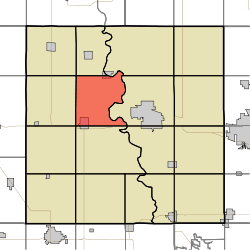
Yell Township covers an area of 32.58 square miles (84.4 km2) and contains one incorporated settlement, Ogden. According to the USGS, it contains six cemeteries: Bluff Creek, Buckley, Hickory Grove, Milton Lott Grave, Mount Olive and Rose Hill.
References
- ↑ "US Board on Geographic Names". United States Geological Survey. 2007-10-25. Retrieved 2008-01-31.
- ↑ "American FactFinder". United States Census Bureau. Retrieved 2008-01-31.
- ↑ Goldthwait, Nathan Edward (1914). History of Boone County, Iowa, Volume 1. Pioneer Publishing Company. p. 197.
- ↑ The History of Boone County, Iowa. Union Historical Company. 1880. p. 528.
External links
Municipalities and communities of Boone County, Iowa, United States | ||
|---|---|---|
| Cities | ||
| Townships | ||
| Unincorporated communities | ||
| Footnotes | ‡This populated place also has portions in an adjacent county or counties | |
This article is issued from Wikipedia - version of the 11/4/2016. The text is available under the Creative Commons Attribution/Share Alike but additional terms may apply for the media files.