Yatenga Province
For the town in India, see Ziro.
| Yatenga | |
|---|---|
| Province | |
 Location in Burkina Faso | |
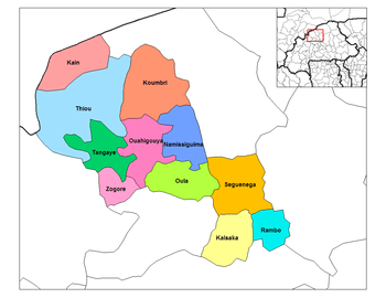 Provincial map of its departments | |
| Country |
|
| Region | Nord Region |
| Capital | Ouahigouya |
| Area | |
| • Total | 6,990 km2 (2,700 sq mi) |
| Population (2011) | |
| • Total | 627,193(est.) |
| Time zone | GMT 0 (UTC+0) |
Yatenga is a modern province in the Nord Region of Burkina Faso. In modern Yatenga, the most prominent city is Ouahigouya (also known as Waiguya). This city served as the capital of the Mossi Kingdoms, but its influence decreased in the century following French colonization. The city is famed today for being home to the Naba's (traditional king's) compound and the tomb of Naba Kango.
History
Kingdom of Yatenga
Yatenge was historically a powerful kingdom in the region. It was founded as a Mossi state along with Ouagadougou, Tenkodogo, and Gourma by invaders from neighboring Ghana. Each of the Mossi states (including Yatenga) possessed a strong military that was able to repel attacks from hostile tribes and nations.
When the European powers began their scramble for territory in Africa in the 19th century, France brokered a deal making Yatenga a French protectorate. Following the annexation of the other Mossi states, the area was governed as Upper Volta until the nation's independence on August 5, 1960.
Education
In 2011 the province had 588 primary schools and 57 secondary schools.[1]
Healthcare
In 2011 the province had 60 health and social promotion centers (Centres de santé et de promotion sociale), 20 doctors and 207 nurses.[2]
Culture
The Yatenga region is renowned for its unique style of Mossi masks. They are tall, vertically oriented, and concave-faced. They are considered to be some of the best examples of Mossi art available today.
Departments
Yatenga is divided into 11 departments:
- Kain Department
- Kalsaka Department
- Koumbri Department
- Namissiguima Department
- Ouahigouya Department
- Oula Department
- Rambo Department
- Seguenega Department
- Tangaye Department
- Thiou Department
- Zogore Department
See also
- Rulers of the Mossi state of Yatenga
- Regions of Burkina Faso
- Provinces of Burkina Faso
- Departments of Burkina Faso
References
- ↑ "La région du Nord en chiffres" (PDF). Institut National de la Statistique et de la Démographie (INSD). 2011. p. 6.
- ↑ "La région du Nord en chiffres" (PDF). Institut National de la Statistique et de la Démographie (INSD). 2011. p. 6.
Coordinates: 13°35′N 2°25′W / 13.583°N 2.417°W