Nord Region (Burkina Faso)
| Nord | |
|---|---|
| Region | |
 | |
 Location in Burkina Faso | |
| Coordinates: 13°15′N 2°15′W / 13.250°N 2.250°WCoordinates: 13°15′N 2°15′W / 13.250°N 2.250°W | |
| Country |
|
| Capital | Ouahigouya |
| Area | |
| • Total | 6,258 sq mi (16,207 km2) |
| Population (2006) | |
| • Total | 1,182,770 |
| Time zone | GMT 0 (UTC+0) |
Nord is one of Burkina Faso's 13 administrative regions. It was created on 2 July 2001. The population of Nord was 1,182,770 in 2006. The region's capital is Ouahigouya. Four provinces make up the region - Loroum, Passoré, Yatenga, and Zondoma.
As of 2010, the population of the region was 1,306,619 with 53.43 per cent females. The population in the region was 8.31 per cent of the total population of the country. The child mortality rate was 88, infant mortality rate was 72 and the mortality of children under five was 153. The coverage of cereal need compared to the total production of the region was 85.00 per cent. As of 2007, the literacy rate in the region was 27 per cent, compared to a national average of 28.3 per cent.
Geography

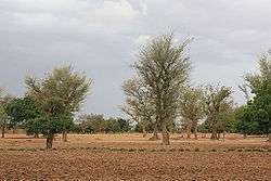
Most of Burkino Faso is a wide plateau formed by riverine systems and is called falaise de Banfora. There are three major rivers, the Red Volta, Black Volta and White Volta, which cuts through different valleys. The climate is generally hot, with unreliable rains across different seasons. Gold and quartz are common minerals found across the country, while manganese deposits are also common.[1] The dry season is usually from October to May and rains are common during the wet season from June to September. The soil texture is porous and hence the yield is also poor.[2] The average elevation is around 200 m (660 ft) to 300 m (980 ft) above mean sea level. Among West African countries, Burkino Faso has the largest elephant population and the country is replete with game reserves.[3] The northern regions are generally arid and usually have scrub land and semi-deserts. The principal river is the Red Volta, that originates in the northern region and drains into Ghana. The areas near the rivers usually have flies like tsete and similium, which are carriers of sleep sickness and river blindness.[1] The average rainfall in the region is around 25 cm (9.8 in) compared to southern regions that receive only 100 cm (39 in) rainfall.[3]
Demographics
As of 2010, the population of the region was 1,306,619 with 53.43 per cent females. The population in the region was 8.31 per cent of the total population of the country. The child mortality rate was 88, infant mortality rate was 72 and the mortality of children under five was 153.[4] As of 2007, among the working population, there were 43.60 per cent employees, 13.70 per cent under employed, 36.80 per cent inactive people, 42.70 per cent not working and 5.90 unemployed people in the region.[5]
Economy
As of 2007, there were 434.5 km (270.0 mi) of highways, 135.4 km (84.1 mi) of regional roads and 569 km (354 mi) of county roads. The first set of car traffic was 40, first set of two-wheeler traffic was 3,061 and the total classified road network was 1,139.[6] The total corn produced during 2015 was 10,256 tonnes, cotton was zero tonnes, cowpea was 110,466 tonnes, ground nut was 26,026 tonnes, millet was 110,057 tonnes, rice was 9,125 tonnes and sorghum was 157,661 tonnes. The coverage of cereal need compared to the total production of the region was 85.00 per cent.[7] As of 2007, the literacy rate in the region was 27 per cent, compared to a national average of 28.3 per cent. The gross primary enrollment was 93.1 per cent, pos-primary was 24 per cent and gross secondary school enrollment was 7.6. There were 233 boys and 372 girls enrolled in the primary and post-secondary level. There were 35 teachers in primary & post-secondary level, while there were 715 teachers in post-primary and post-secondary level.[8]
Local administration
| Province | Capital | 2006[9] |
|---|---|---|
| Loroum Province | Titao | 142,990 |
| Passoré Province | Yako | 322,873 |
| Yatenga Province | Ouahigouya | 547,952 |
| Zondoma Province | Gourcy | 168,955 |
Burkina Faso got independence from French Colonial Empire during 1960. It was originally called Upper Volta. There have been military coups till 1983 when Captain Thomas Sankara took control and implemented radical left wing policies. He was outsed by Blaise Compaore, who continued for 27 years till 2014, when a popular uprising ended his rule.[10] As per Law No.40/98/AN in 1998, Burkina Faso adhered to decentralization to provide administrative and financial autonomy to local communities. There are 13 administrative regions, each governed by a Governor. The regions are subdivided into 45 provinces, which are further subdivided into 351 communes. The communes may be urban or rural and are interchangeable. There are other administrative entities like department and village. An urban commune has typically 10,000 people under it. If any commune is not able to get 75 per cent of its planned budget in revenues for 3 years, the autonomy is taken off. The communes are administered by elected Mayors. The communes are stipulated to develop economic, social and cultural values of its citizens. A commune has financial autonomy and can interact with other communes, government agencies or international entities.[11]
References
- 1 2 Haggett, Peter, ed. (2002). Encyclopedia of World Geography, Volume 17. Marshall Cavendish. ISBN 9780761473060.
- ↑ Dobson, James C.; Sander, John M.; Woodfield, Judith (2001). Living Geography: Homework and Assessment, Book 3. Nelson Thornes. p. 29. ISBN 9780174343257.
- 1 2 Burkina Faso Mining Laws and Regulations Handbook. Int'l Business Publications. 2008. p. 19. ISBN 9781433077074.
- ↑ "Demographics of Burkina Faso". National Institute of Statistics and Demographics, Burkina Faso. 2010. Retrieved 17 November 2016.
- ↑ "Employment statistics of Burkina Faso". National Institute of Statistics and Demographics, Burkina Faso. 2007. Retrieved 17 November 2016.
- ↑ "Transport in Burkina Faso". National Institute of Statistics and Demographics, Burkina Faso. 2008. Retrieved 17 November 2016.
- ↑ "Agricultural statistics of Burkina Faso". National Institute of Statistics and Demographics, Burkina Faso. 2015. Retrieved 17 November 2016.
- ↑ "Education statistics of Burkina Faso". National Institute of Statistics and Demographics, Burkina Faso. 2010. Retrieved 17 November 2016.
- ↑ "National 2006 census preliminary results" (PDF). 2006. Retrieved 24 November 2016.
- ↑ "Burkina Faso country profile". BBC. 5 August 2016. Retrieved 20 November 2016.
- ↑ Republic of Burkina Faso, Public Administration and Country profile (PDF) (Report). Department of Economic and Social Affairs (DESA), United Nations. 2004. p. 9. Retrieved 17 November 2016.