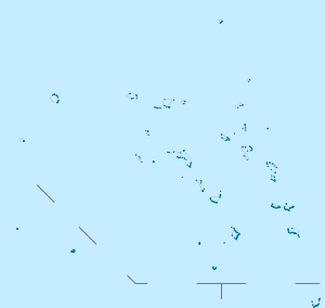
Wotje Atoll
|
NASA picture of Erikub and Wotje Atolls | |
 Wotje Atoll Wotje Atoll (Marshall islands) | |
| Geography | |
|---|---|
| Location | North Pacific |
| Coordinates | 09°26′30″N 170°01′00″E / 9.44167°N 170.01667°E |
| Archipelago | Ratak |
| Total islands | 75 |
| Area | 8.18 km2 (3.16 sq mi) |
| Highest elevation | 3 m (10 ft) |
| Administration | |
| Demographics | |
| Population | 1000 (2007) |
| Ethnic groups | Marshallese |
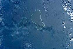
Wotje Atoll (Marshallese: Wōjjā, [ɔ̯ɔ͡ɛtʲːææ̯][1]) is a coral atoll of 75 islands in the Pacific Ocean, and forms a legislative district of the Ratak Chain of the Marshall Islands. Wotje's land area of 8.18 square kilometres (3.16 sq mi) is one of the largest in the Marshall Islands, and encloses a lagoon of 624 square kilometres (241 sq mi). The atoll is oriented east and west and is 45 kilometres (28 mi) at its longest point, and 18 kilometres (11 mi) at its greatest width. In 1999, the population of the islands in atoll was 900. As of 2007, the population was nearly 1,000, which included about 200 teenagers who live on the island at the public boarding school, Northern Islands High School. The Wotje Atoll includes a number of islets, including Wotje (the largest), Bodao, Enejeltalk, Ukon, Wetwirok, Kaiken, Wormej, Kimajo, Ninum, Kaben. About 125 people live on Wodmej, which is approximately 8 miles from the main island of Wotje. All other islands are uninhabited and are used only for copra production, picnics, and food gathering.
There are four churches on Wotje, Wotje: Catholic (which runs St. Thomas Elementary School), Protestant, Assembly of God, and Full Gospel. There are several stores, but the largest is Mama Store, managed by the Tomeing-Johnny family. This store has a small retail shop, restaurant and coffee window. Wotje Atoll has four schools: Wodmej Elementary School, Wotje Elementary School, St. Thomas Elementary School, and Northern Islands High School. The first three are public schools, funded by the national Ministry of Education. St. Thomas is managed by the Maryknoll Sisters of the Catholic Church.
Wotje, Wotje is serviced by ships several times a year which bring supplies like rice, flour, and sugar. In addition, the local government and senator manage a small ship, Northern Star, which makes more frequent trips. Air services are provided by Air Marshall Islands to Wotje Airport.
History
First recorded sighting by Europeans was by the Spanish expedition of Ruy López de Villalobos on 25 December 1542 that charted it as Los Corales (The Coral Islands in Spanish) because of the many corals and having anchored in these. One of the islets of this atoll was charted as San Esteban by Villalobos because they landed on it on St. Stephen's day (26 December 1542).[2][3][4]
Wotje Atoll was claimed by the Empire of Germany along with the rest of the Marshall Islands in 1884, and the Germans established a trading outpost. After World War I, the island came under the South Pacific Mandate of the Empire of Japan. The Japanese established a school on the island, which served the atolls of the Ratak Chain, but otherwise left administration in the hands of local authorities.

However, from the end of the 1930s, Wotje was developed as into a major seaplane base, and also had an airfield with two runways for land-based aircraft, and several hundred support buildings. During World War II the atoll was garrisoned by the Japanese.[5] The coasts were heavily fortified with coastal artillery and anti-aircraft batteries. The only bombing of Hawaii after Pearl Harbor was executed by seaplanes from Wotje.[6] The Japanese garrison at Wotje at its peak numbered 2,959 men from the Imperial Japanese Navy, 424 men from the Imperial Japanese Army[5] and some 750 civilian workers, many of whom were conscripted ethnic Koreans. From mid-1943 the island came under attack by United States Navy carrier-based aircraft, and was frequently shelled by warships. The attacks increased in frequency and severity after the fall of Majuro and Kwajalein to American forces, and all supply lines to Wotje were cut. By the surrender of Japan, only 1244 men of the garrison remained alive.
Following the end of World War II, Wotje came under the control of the United States as part of the Trust Territory of the Pacific Islands until the independence of the Marshall Islands in 1986. Many World War II artifacts remain on the main island of Wotje, including a large concrete airstrip, bunkers and big guns.
Climate
| Climate data for Wotje | |||||||||||||
|---|---|---|---|---|---|---|---|---|---|---|---|---|---|
| Month | Jan | Feb | Mar | Apr | May | Jun | Jul | Aug | Sep | Oct | Nov | Dec | Year |
| Average high °C (°F) | 29 (84) |
30 (86) |
30 (86) |
30 (86) |
30 (86) |
30 (86) |
30 (86) |
30 (86) |
30 (86) |
30 (86) |
30 (86) |
29 (84) |
29 (84) |
| Average low °C (°F) | 25 (77) |
25 (77) |
25 (77) |
25 (77) |
25 (77) |
25 (77) |
25 (77) |
25 (77) |
25 (77) |
25 (77) |
25 (77) |
25 (77) |
25 (77) |
| Average precipitation mm (inches) | 109 (4.3) |
80 (3) |
114 (4.5) |
180 (7.1) |
236 (9.3) |
244 (9.6) |
250 (10) |
264 (10.4) |
290 (11.4) |
295 (11.6) |
287 (11.3) |
206 (8.1) |
2,553 (100.5) |
| Source: Weatherbase [7] | |||||||||||||
Notes
- ↑ Marshallese-English Dictionary - Place Name Index
- ↑ Coello, Francisco "Conflicto hispano-alemán" Boletín de Sociedad Geográfica de Madrid, t.XIX. 2º semestre 1885, Madrid, p.279,281
- ↑ Sharp, Andrew (1960). The discovery oif the Pacific Islands. Oxford: Clarendon Press. p. 28.
- ↑ Martinez Shaw, Carlos (1999). Relación del viaje que hizo desde Nueva España a las Islas de Poniente, despues Filipinas, Ruy López de Villalobos, de orden del Virrey de Nueva España, Don Antonio de Mendoza / García de Escalante Alvarado. Santander: Universidad de Cantabria. p. 42. ISBN 84-8102-234-9.
- 1 2 Takizawa, Akira; Alsleben, Allan (1999–2000). "Japanese garrisons on the by-passed Pacific Islands 1944-1945". Forgotten Campaign: The Dutch East Indies Campaign 1941-1942.
- ↑ Stage, Anson H. (1999). "During a little-known raid, Japan's newest four-engine flying boat was put to a challenging test: a flight of more than 3,000 miles to attack Hawaii.". Forgotten Campaign: The Dutch East Indies Campaign 1941-1942.
- ↑ "Weatherbase: Historical Weather for Wotje, Marshall Islands". Weatherbase. 2011. Retrieved on November 24, 2011.
References
- L, Klemen (1999–2000). "Forgotten Campaign: The Dutch East Indies Campaign 1941-1942".
External links
- Japanese seaplane base on Wotje
- Oceandots entry for Wotje at the Wayback Machine (archived December 23, 2010)
- Marshall Islands site
| ||
| Ratak Chain (Sunrise, Eastern) |  | |
| Ralik Chain (Sunset, Western) | ||