Rongerik Atoll
|
NASA picture of Rongerik Atoll | |
 Rongerik Atoll | |
| Geography | |
|---|---|
| Location | North Pacific |
| Coordinates | 11°20′N 167°27′E / 11.333°N 167.450°E |
| Archipelago | Ralik |
| Total islands | 22 |
| Area | 1.68 km2 (0.65 sq mi) |
| Highest elevation | 3 m (10 ft) |
| Administration | |
| Demographics | |
| Population | 0 |
| Ethnic groups | Marshallese (formerly) |
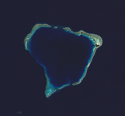
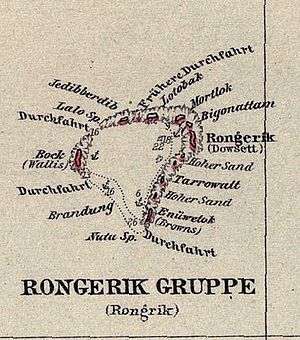
Rongerik Atoll or Rongdrik Atoll (Marshallese: Ron̄dik, [rʷɔŋʷ(o͡e)r̪ʲi͡ɯk][1]) is a coral atoll of 17 islands in the Pacific Ocean, and is located in the Ralik Chain of the Marshall Islands, approximately 200 kilometres (120 mi) east of Bikini Atoll. Its total land area is only 1.68 square kilometres (0.65 sq mi), but it encloses a lagoon of 144 square kilometres (56 sq mi).
History
Rongerik Atoll was claimed by the Empire of Germany along with the rest of the Marshall Islands in 1884. After World War I, the island came under the South Pacific Mandate of the Empire of Japan, although the island was uninhabited. Following the end of World War II, it came under the control of the United States as part of the Trust Territory of the Pacific Islands until the independence of the Marshall Islands in 1986.
It is most famous as the temporary location from March 7, 1946 through March 14, 1948 of the Bikini Atoll's indigenous population while the United States government conducted the Operation Crossroads nuclear tests. After months of food shortages and malnutrition, they were moved first to Kwajalein and finally to Kili Island. On March 1, 1954, Rongerik was exposed to radioactive fallout as a result of the detonation of Operation Castle's Bravo.
Traditionally, Marshall Islanders believe Rongerik to be haunted by the Demon Girls of Ujae, which contributed to its not being inhabited.
According to Spanish researcher Emilio Pastor in a paper submitted to his government in 1948, a number of small islands in Micronesia (Kapingamarangi or Coroa, Mapia or Güedes, Ocea or Matador, and Rongerik or Pescadores) continue legally under Spanish sovereignty. This is because the text of the German–Spanish Treaty of 1899 which transferred sovereignty of certain Spanish possessions in the Pacific to Germany, namely the Northern Mariana Islands (except Guam) and the Caroline Islands (including Palau), failed to include these smaller islands. Although the Spanish government studied the case in 1949 and accepted this interpretation, it has not asserted its claim to the islands.[2]
.png)
See also
- Also contaminated by Castle Bravo test: Rongelap Atoll, Utirik Atoll, Ailinginae Atoll
References
External links
- Marshall Islands site
- Entry at Oceandots.com at the Wayback Machine (archived December 23, 2010)
- A Short History of the People of Bikini Atoll
- The Story of the Demon Girls of Ujae
| Wikimedia Commons has media related to Rongerik Atoll. |
| ||
| Ratak Chain (Sunrise, Eastern) |  | |
| Ralik Chain (Sunset, Western) | ||