Worcester Street

Worcester Street is a street in west central Oxford, England.[1]
History
The street was formerly known as Stockwelle Street, also running along the line of Walton Street and Little Clarendon Street, to the north of the current Worcester Street.[1] The name "Stoke" or "Stock" is other associated with streams. At the junction with Hythe Bridge Street, there was a well, known as Cornwell or Cornwall. The Carmelites (also known as Whitefriars) settled in the street in 1256. The street was built up by 1279 and Gloucester College was established in 1283. The Carmelites moved to Beaumont Palace nearby in 1317. In the Tudor period, Cornwell became known as Plato's Well, distinguishing it from Aristotle's Well close to Aristotle Lane to the north. In 1714, Gloucester College was re-established as Worcester College and the street became known as Worcester Street by around 1850.
Location
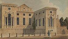
The street runs north-south in two sections that are separated for traffic. The northern section forms part of the A4144 road. It starts opposite the eponymous Worcester College, one of the colleges of the University of Oxford, at the junction with Beaumont Street and Walton Street. Worcester College occupies the entire western side of this portion of the street and Gloucester Green, the location of Oxford's bus station, is to the east. The Refugee Studies Centre, part of the University of Oxford’s Department of International Development, is also located here. The road continues round to the west as Hythe Bridge Street, past the Oxford Canal towards Oxford railway station.
The southern section runs between George Street and the junction of Park End Street and New Road at the southern end. Worcester Street Car Park,[2] formerly a wharf for the loading and unloading of goods near the end of the Oxford Canal, is to the west. The land was intended to be used for part of Nuffield College, but budgetary constraints meant that only the site to the east of Worcester Street was developed. The canal used to continue under Worcester Street Bridge to a coal wharf in New Road. To the east at the southern end of Worcester Street is Nuffield College, a graduate college of Oxford University, built between 1951 and 1960 on the site of the coal wharf.
The Oxford Job Centre is at 7 Worcester Street.[3]
See also
References
- 1 2 Hibbert, Christopher, ed. (1988). "Worcester Street". The Encyclopaedia of Oxford. Macmillan. p. 506. ISBN 0-333-39917-X.
- ↑ "Worcester Street Car Park, Oxford". UK: Qype. Retrieved 9 December 2012.
- ↑ "Oxford Job Centre Plus". The Job Centre Guide. UK. Retrieved 9 December 2012.
Coordinates: 51°45′14″N 1°15′48″W / 51.753839°N 1.263455°W