Oxford Canal
Coordinates: 52°27′N 1°28′W / 52.450°N 1.467°W

The Oxford Canal is a 78-mile-long (126 km) narrow canal in central England linking Oxford with Coventry via Banbury and Rugby. It connects with the River Thames at Oxford, to the Grand Union Canal at the villages of Braunston and Napton-on-the-Hill, and to the Coventry Canal at Hawkesbury Junction in Bedworth just north of Coventry. The canal was once an important artery of trade between the English Midlands and London, and is now highly popular among pleasure boaters.
The Oxford Canal passes mainly through the Oxfordshire, Northamptonshire and Warwickshire countryside, and is often considered to be one of the most scenic canals in Britain. North of Napton-on-the-Hill, the canal forms part of the Warwickshire ring.
The route
| Oxford Canal Route map | |||||||||||||||||||||||||||||||||||||||||||||||||||||||||||||||||||||||||||||||||||||||||||||||||||||||||||||||||||||||||||||||||||||||||||||||||||||||||||||||||||||||||||||||||||||||||||||||||||||||||||||||||||||||||||||||||||||||||||||||||||||||||||||||||||||||||||||||||||||||||||||||||||||||||||||||||||||||||||||||||||||||||||||||||||||||||||||||||||||||||||||||||||||||||||||||||||||||||||||||||||||||||||||||||||||||||||||||||||||||||||||||||||||||||||||||||||||||||||||||||||||||||||||||||||||||||||||||||||||||||||||||||||||||||||||||||||||||||||||||||||||||||||||||||||||||||||||||||||||||||||||||||||||||||||||||||||||||||||||||||||||||||||||||||||||||||||||||||||||||||||||||||||||||||||||||||||||||||||||||||||||||||||||||||||||||||||||||||||||||||||||||||||||||||||||||||||||||||||||||||||||||||||||||||||||||||||||||||||||||||||||||||||||||||||||||||||||||||||||||||||||||||||||||||||||||||||||||||||||||||||||||||||||||||||||||||||||||||||||||||||||||||||||||||||||||||||||||||||||||
|---|---|---|---|---|---|---|---|---|---|---|---|---|---|---|---|---|---|---|---|---|---|---|---|---|---|---|---|---|---|---|---|---|---|---|---|---|---|---|---|---|---|---|---|---|---|---|---|---|---|---|---|---|---|---|---|---|---|---|---|---|---|---|---|---|---|---|---|---|---|---|---|---|---|---|---|---|---|---|---|---|---|---|---|---|---|---|---|---|---|---|---|---|---|---|---|---|---|---|---|---|---|---|---|---|---|---|---|---|---|---|---|---|---|---|---|---|---|---|---|---|---|---|---|---|---|---|---|---|---|---|---|---|---|---|---|---|---|---|---|---|---|---|---|---|---|---|---|---|---|---|---|---|---|---|---|---|---|---|---|---|---|---|---|---|---|---|---|---|---|---|---|---|---|---|---|---|---|---|---|---|---|---|---|---|---|---|---|---|---|---|---|---|---|---|---|---|---|---|---|---|---|---|---|---|---|---|---|---|---|---|---|---|---|---|---|---|---|---|---|---|---|---|---|---|---|---|---|---|---|---|---|---|---|---|---|---|---|---|---|---|---|---|---|---|---|---|---|---|---|---|---|---|---|---|---|---|---|---|---|---|---|---|---|---|---|---|---|---|---|---|---|---|---|---|---|---|---|---|---|---|---|---|---|---|---|---|---|---|---|---|---|---|---|---|---|---|---|---|---|---|---|---|---|---|---|---|---|---|---|---|---|---|---|---|---|---|---|---|---|---|---|---|---|---|---|---|---|---|---|---|---|---|---|---|---|---|---|---|---|---|---|---|---|---|---|---|---|---|---|---|---|---|---|---|---|---|---|---|---|---|---|---|---|---|---|---|---|---|---|---|---|---|---|---|---|---|---|---|---|---|---|---|---|---|---|---|---|---|---|---|---|---|---|---|---|---|---|---|---|---|---|---|---|---|---|---|---|---|---|---|---|---|---|---|---|---|---|---|---|---|---|---|---|---|---|---|---|---|---|---|---|---|---|---|---|---|---|---|---|---|---|---|---|---|---|---|---|---|---|---|---|---|---|---|---|---|---|---|---|---|---|---|---|---|---|---|---|---|---|---|---|---|---|---|---|---|---|---|---|---|---|---|---|---|---|---|---|---|---|---|---|---|---|---|---|---|---|---|---|---|---|---|---|---|---|---|---|---|---|---|---|---|---|---|---|---|---|---|---|---|---|---|---|---|---|---|---|---|---|---|---|---|---|---|---|---|---|---|---|---|---|---|---|---|---|---|---|---|---|---|---|---|---|---|---|---|---|---|---|---|---|---|---|---|---|---|---|---|---|---|---|---|---|---|---|---|---|---|---|---|---|---|---|---|---|---|---|---|---|---|---|---|---|---|---|---|---|---|---|---|---|---|---|---|---|---|---|---|---|---|---|---|---|---|---|---|---|---|---|---|---|---|---|---|---|---|---|---|---|---|---|---|---|---|---|---|---|---|---|---|---|---|---|---|---|---|---|---|---|---|---|---|---|---|---|---|---|---|---|---|---|---|---|---|---|---|---|---|---|---|---|---|---|---|---|---|---|---|---|---|---|---|---|---|---|---|---|---|---|---|---|---|---|---|---|---|---|---|---|---|---|---|---|---|---|---|---|---|---|---|---|---|---|---|---|---|---|---|---|---|---|---|---|---|---|---|---|---|---|---|---|---|---|---|---|---|---|---|---|---|---|---|---|---|---|---|---|---|---|---|---|---|---|---|---|---|---|---|---|---|---|---|---|---|---|---|---|---|---|---|---|---|---|---|---|---|---|---|---|---|---|---|---|---|---|---|---|---|---|---|---|---|---|---|---|---|---|---|---|---|---|---|---|---|---|---|---|---|---|---|---|---|---|---|---|---|---|---|---|---|---|---|---|---|---|---|---|---|---|---|---|---|---|---|---|---|---|---|---|---|---|---|---|---|---|---|---|---|---|---|---|---|---|---|---|---|---|---|---|---|---|---|---|---|---|---|---|---|---|---|---|---|---|---|---|---|---|---|---|---|---|---|---|---|---|---|---|---|---|---|---|---|---|---|---|---|---|---|---|---|---|---|---|---|---|---|---|---|---|---|---|---|---|---|---|---|---|---|---|---|---|---|---|---|---|---|---|---|---|---|---|---|---|---|---|---|---|---|---|---|---|---|---|---|---|---|---|---|---|---|---|---|---|---|---|---|---|---|---|---|---|---|---|---|---|---|---|---|---|---|---|---|---|---|---|---|---|---|---|---|---|---|---|---|---|---|---|---|---|---|---|---|---|---|---|---|---|---|---|
legend
| |||||||||||||||||||||||||||||||||||||||||||||||||||||||||||||||||||||||||||||||||||||||||||||||||||||||||||||||||||||||||||||||||||||||||||||||||||||||||||||||||||||||||||||||||||||||||||||||||||||||||||||||||||||||||||||||||||||||||||||||||||||||||||||||||||||||||||||||||||||||||||||||||||||||||||||||||||||||||||||||||||||||||||||||||||||||||||||||||||||||||||||||||||||||||||||||||||||||||||||||||||||||||||||||||||||||||||||||||||||||||||||||||||||||||||||||||||||||||||||||||||||||||||||||||||||||||||||||||||||||||||||||||||||||||||||||||||||||||||||||||||||||||||||||||||||||||||||||||||||||||||||||||||||||||||||||||||||||||||||||||||||||||||||||||||||||||||||||||||||||||||||||||||||||||||||||||||||||||||||||||||||||||||||||||||||||||||||||||||||||||||||||||||||||||||||||||||||||||||||||||||||||||||||||||||||||||||||||||||||||||||||||||||||||||||||||||||||||||||||||||||||||||||||||||||||||||||||||||||||||||||||||||||||||||||||||||||||||||||||||||||||||||||||||||||||||||||||||||||||||

.png)
The canal begins near Hawkesbury Village at Hawkesbury Junction, also known as Sutton Stop, where it connects with the Coventry Canal, four miles from the centre of Coventry. From Hawkesbury, it runs south east through the Warwickshire countryside for 15 miles (24 km) to Rugby.
The route between Coventry and Rugby is on a level with no locks, apart from the stop lock at the junction. Much of this section of the canal was straightened out in the 1820s, and remains of the original less direct route (which hugged the chosen contour) can still be seen in places.
The canal winds through the northern part of Rugby passing through the 270-yard (250 m) long Newbold Tunnel, and then reaches a flight of three locks at Hillmorton just east of Rugby. In the churchyard in Newbold-on-Avon remains can be seen of the original tunnel dating from the 1770s.
South of Rugby, the canal passes through rural scenery and doubles back on itself for several miles until it heads southwards again passing for a short distance into Northamptonshire towards Braunston.
At Braunston the Oxford connects with the Grand Junction section of the Grand Union Canal and heads west. Grand Union traffic shares a five-mile stretch of the Oxford Canal until they diverge at Napton junction, where the Oxford turns south towards Oxford and the Warwick and Napton section of the Grand Union turns north-west towards Birmingham.
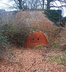
After winding round Napton Hill, the canal ascends the Napton flight of nine locks to a summit level. After passing an old wharf and a pub at Fenny Compton, the canal enters a long cutting which, until it was opened out in the 19th century, was a tunnel. This section is still referred to as 'tunnel straight' or the Fenny Compton Tunnel.
Because the section south of Napton junction was never straightened, the summit level remains one of the most twisting sections of canal in England. It winds for 11 miles (18 km) between two points which are under five miles apart. This is the "eleven-mile pound" mentioned in Tom Rolt's Narrow Boat.
The canal then reaches the Claydon flight of locks and descends into the valley of the River Cherwell at Cropredy (the canal descends the river valley all the way from here to Oxford).

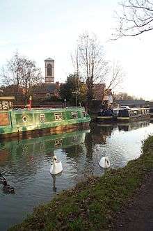
Banbury is a major stop on the route because of the large number of visitor moorings on a paved and relatively secure mooring right alongside the shopping centre in the middle of town. Banbury, unlike some towns, has attempted to treat the canal as an attraction to be encouraged, rather than an eyesore to be shunned, and an old boatyard has been incorporated into the development as Tooley's Historic Boatyard. About 4 miles (6.4 km) to the south there is the small hamlet, Twyford Wharf, where narrow boats up to 60 feet (18 m) can be turned. The listed single track humped back bridge No 177 at Twyford Wharf has recently (4 October 2016 and 4 September 2015) been damaged and is in need of urgent repair. There are two villages nearby, Kings Sutton and Adderbury (Twyford), within 30 minutes walking distance along the road. Both offer several pubs.
At Oxford, the canal has two connections to the River Thames. The first is 3 miles (4.8 km) north of the city where Dukes Cut leads to King's Lock; the second is a few hundred yards from the city centre by the Oxford railway station [1] below Isis Lock (known to boatmen as 'Louse Lock') through Sheepwash Channel.[2] This leads to an unusual river crossroads at the Thames called "Four Rivers" above Osney Lock.
After 330 yards (300 m) below Isis Lock the Oxford Canal ends abruptly at Hythe Bridge Street near to the current Hythe Bridge over the Castle Mill Stream, a backwater of the River Thames that runs parallel to the Oxford Canal for its southernmost part. The canal used to continue through a bridge under Hythe Bridge Street to a turning basin and goods wharf south of Hythe Bridge Street. It then continued via a bridge under Worcester Street to end in a coal wharf beside New Road. In 1951 the basin and wharves were filled in and Nuffield College now stands on part of the site.

History
Construction
The Oxford Canal was constructed in several stages over a period of more than twenty years.
In 1769 an Act of Parliament authorising the Oxford Canal was passed, having been promoted in Parliament by Sir Roger Newdigate MP, who chaired the canal company. The intention was to link the industrial English Midlands to London via the River Thames. Construction began shortly after near Coventry.
Surveying of the route and initial construction were originally supervised by the celebrated engineer James Brindley, assisted by Samuel Simcock who was also Brindley's brother-in-law. Brindley died in 1772 but Simcock took over and completed the canal. By 1774 the canal had reached Napton, but the company was already running out of money.
In 1775, a second Act was passed allowing the company to raise more funds. Construction soon started again and by 1778 the canal had reached Banbury. Financial problems meant that work on the final stretch to Oxford did not begin until 1786.
The stretch of the canal from Banbury to Oxford was built as cheaply as possible. Many economy measures were used. Wherever possible, wooden lift or swing bridges were built instead of expensive brick ones. Deep locks were used wherever possible, with single gates at both ends instead of double gates.
A stretch of the River Cherwell at Shipton-on-Cherwell was incorporated into the canal. This reduced construction costs, but the behaviour of the river makes the canal more difficult to use. This was a false economy and its adverse effects continue to be felt to this day.
The Oxford Canal reached the outskirts of Oxford in 1789, when a coal wharf was opened at Heyfield Hutt, now the site of Hayfield Road. The final section into central Oxford was ceremonially opened on 1 January 1790.
Commercial use
For the next 15 years the Oxford Canal became one of the most important and profitable transport links in Britain, with most commercial traffic between London and the Midlands using the route. Its principal traffic was coal from Warwickshire. It also carried stone, agricultural products and other goods.
A much more direct route between London and the Midlands, the Grand Junction Canal, was completed in 1805. Much of the London-bound traffic switched to this faster route, as it avoided the passage of the River Thames which still had many flash locks. This greatly reduced Oxford Canal traffic south of Napton. However, the short section between Braunston and Napton became the link between the Warwick and Napton Canal and the Grand Junction Canal, making it part of the busy direct route between Birmingham and London.
The Grand Junction and Oxford canal companies were bitter rivals. When Parliament considered the Act of Parliament for the building of the Grand Junction, the Oxford Canal successfully petitioned to make the Grand Junction pay "bar tolls" to the Oxford Canal to compensate for the loss of traffic south of Napton.
Traffic from Birmingham had to use 5 miles (8.0 km) of the Oxford Canal to get from Braunston to join the Grand Junction at Napton. The Oxford Canal exploited this by charging high tolls for Grand Junction traffic on this short section.
The Oxford Canal was originally built as a contour canal, meaning that it twisted around hills to minimise vertical deviations from a level contour. However, with one eye on the developing railway network, in the 1820s the northern section of the canal between Braunston and Hawkesbury Junction was straightened out to reduce navigation time. This work reduced the distance by 14 miles 6 furlongs (23.7 km). The section south of Napton was never straightened.
The straightening challenged the capacity of three locks at Hillmorton, the first on the canal after the stop lock at Hawkesbury Junction. The solution to the congestion was to duplicate or twin the existing locks at Hillmorton, creating three pairs of two parallel narrow locks, which allowed for twice the traffic to pass the lock at any time. The work to double the locks was completed in August 1840. Not only was the capacity to pass the lock doubled, but the time taken was decreased as the locks were narrower. Tests showed that the locks could be operated in as little as one minute and 20 seconds!
The northern section of the Oxford Canal between Coventry, Braunston and Napton remained an important trunk route, and remained extremely busy with freight traffic until the 1960s. The staple traffic was coal from the Warwickshire and Leicestershire coalfields to London via the Grand Union Canal. However, the southern section from Napton to Oxford became something of a backwater, and carried mostly local traffic.
Decline
In 1937 Baron Nuffield (Later Viscount Nuffield) bought the canal basin at Oxford. In 1951 he filled it in and built Nuffield College on part of the former coal wharf. Coal traffic was relocated to a canal wharf in Juxon Street, in Jericho, Oxford. The goods wharf and the remainder of the coal wharf are now under a public car park that Nuffield College lets to Oxford City Council.
The Oxford Canal remained independent until it was nationalised in 1948 and became part of the Docks and Inland Waterways Executive, later the British Waterways Board.
Many Oxford Canal boatmen and women favoured horse traction long after those on other canals had changed their narrowboats to diesel power. One narrowboat carrying coal on the Oxford Canal was drawn by a mule until 1959 and was the last horse-drawn freight narrowboat in Great Britain. This boat, Friendship, is preserved at the National Waterways Museum, Ellesmere Port.[3]
The Oxford Canal remained profitable until the mid-1950s, paying a dividend right up until nationalisation. As with most of Britain's narrow canal system, the Oxford Canal suffered from a rapid decline in freight traffic after the Second World War. By the mid-1950s very few narrowboats traded south of Napton and the southern section was at one point being threatened with closure, although the northern section (Napton to Coventry) remained well-used by commercial traffic until the 1960s.
Revival
During the 1960s pleasure boating began to grow in popularity and replace the old trading boats, After a fact-finding cruise on the canal, Barbara Castle (Minister for Transport) rejected a proposal for closure.
The canal is now thriving. In the summer it is one of the most crowded canals on the network.
Oxford Canal Walk
The towpath of the canal, with a 5 1⁄2-mile (9 km) extension from Hawkesbury Junction to Coventry on the towpath of the Coventry Canal, forms the 82-mile (132 km) Oxford Canal Walk. The 10-mile (16 km) stretch from Oxford to Kirtlington, where the Oxfordshire Way meets the canal, is also part of European walking route E2.[4] The Canal Walk is popular with geocachers with many Geocache sites located alongside the canal.[5]
See also
References
Notes
- ↑ "Canal Guide (Oxford Canal)". UK: Canal Guide.
- ↑ "River Thames (Sheepwash Channel)". canalplan.org.uk. UK: CanalPlanAC. Retrieved 15 September 2012.
- ↑ "Historic Boat Record". Retrieved 23 February 2010.
- ↑ Ramblers Association: info on Oxford Canal Walk
- ↑ "A Slight Diversion – Oxford Canal Walk". Geocaching.com. Retrieved 14 April 2016.
Bibliography
- British Waterways Board (1965). Inland Cruising Booklet 6: Cruising on the Oxford Canal (New ed.). London: British Waterways Board.
- Compton, Hugh J (1976). The Oxford Canal. Newton Abbot: David & Charles. ISBN 0-7153-7238-6. OCLC 3198544.
- Davies, Mark; Robinson, Catherine (2003) [2001]. A Towpath Walk in Oxford. Oxford: Oxford Towpath Press. ISBN 0-9535593-1-9.
- Rolt, LTC (1944). Narrow Boat. ISBN 0-413-22000-1.
- Waterways World (1989). Oxford Canal Cruising Guide. ISBN 1-870002-25-3.
External links
| Wikimedia Commons has media related to Oxford Canal. |
- British Waterways "Waterscape" webpage about the Oxford Canal
- Detail of towns, history etc. along the Oxford Canal
| Next confluence upstream | River Thames | Next confluence downstream |
| River Evenlode (north) | Oxford Canal | Castle Mill Stream (north) |
Northamptonshire Portal | |
| Boroughs or districts | |
| Major settlements | |
| Rivers | |
| Canals | |
| Topics | |