Worcester (CDP), New York
| Worcester, New York | |
|---|---|
| Census-designated place | |
 Worcester, New York Location within the state of New York | |
| Coordinates: 42°35′30″N 74°45′1″W / 42.59167°N 74.75028°WCoordinates: 42°35′30″N 74°45′1″W / 42.59167°N 74.75028°W | |
| Country | United States |
| State | New York |
| County | Otsego |
| Area | |
| • Total | 8.6 sq mi (22.3 km2) |
| • Land | 8.6 sq mi (22.2 km2) |
| • Water | 0.04 sq mi (0.1 km2) |
| Elevation | 1,330 ft (410 m) |
| Population (2010) | |
| • Total | 1,113 |
| • Density | 130/sq mi (50/km2) |
| Time zone | Eastern (EST) (UTC-5) |
| • Summer (DST) | EDT (UTC-4) |
| Area code(s) | 607 |
Worcester is a census-designated place (CDP) forming the central settlement of the town of Worcester in Otsego County, New York, United States. The population of the CDP was 1,113 at the 2010 census.[1]
Geography
Worcester is located at 42°35′30″N 74°45′1″W / 42.59167°N 74.75028°W (42.59172, -74.75050),[2] along New York State Route 7. Interstate 88 skirts the south edge of the CDP, serving the community via Exit 19, one mile (1.6 km) east of the CDP center.
According to the United States Census Bureau, the CDP has a total area of 8.6 square miles (22.3 km2), of which 8.6 square miles (22.2 km2) is land and 0.039 square miles (0.1 km2), or 0.53%, is water.[3]
References
- ↑ "Profile of General Population and Housing Characteristics: 2010 Demographic Profile Data (DP-1): Worcester CDP, New York". U.S. Census Bureau, American Factfinder. Retrieved July 13, 2012.
- ↑ "Worcester, NY". U.S. Geological Survey 7.5-minute topographic map series, mapper.acme.com
- ↑ "Geographic Identifiers: 2010 Demographic Profile Data (G001): Worcester CDP, New York". U.S. Census Bureau, American Factfinder. Retrieved July 13, 2012.
Municipalities and communities of Otsego County, New York, United States | ||
|---|---|---|
| City | 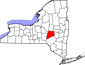 | |
| Towns | ||
| Villages | ||
| CDPs | ||
| Other hamlets | ||
| Footnotes | ‡This populated place also has portions in an adjacent county or counties | |
This article is issued from Wikipedia - version of the 9/7/2016. The text is available under the Creative Commons Attribution/Share Alike but additional terms may apply for the media files.