Woodside, Aberdeen

Coordinates: 57°10′15″N 2°07′31″W / 57.170754°N 2.1252°W
Woodside is part of the city of Aberdeen. It came into existence as a quoad sacra parish within the parish of Old Machar in 1834, under an act of The General Assembly of the Church of Scotland of May 31, 1834 (IX. Sess. 10, May 31, 1834. – Declaration Enactment as to Chapels of Ease),[2] and was named for the principal residence of the area, Woodside House.
Within this parish which was bounded to the north by the River Don there were three villages, Woodside, Tanfield and Cotton (also known as Nether Cottown).[3] Its population in 1841 was 4,893 living in 440 houses. By 1868 it had become a police burgh[4] and the community was being described as a village in its own right (distinct from the quoad sacra parish of which it was the largest part), and a suburb of Aberdeen. It was part of the Aberdeen Burgh Parliamentary constituency.[5]
By 1881, it had developed into a community of 5,452 (the population of quoad sacra parish population growing to 5,928). It had its own separate post office, a railway station, paper works, a free library, a public school, and a number of churches of various denominations.[6] Ten years later, in 1891 it, (along with Old Aberdeen and Torry) was formally incorporated into the city of Aberdeen.[7]
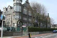
Woodside School
Woodside School is on the corner of Clifton Road and Smithfield Road. The head teacher is Mrs Cook.
The first part of the school was built in 1890, and it was extended in 1902; these dates are on the building. The nursery is in a separate building and has its own garden.
-
Woodside Primary School
-

Woodside Primary School Dux Board
-

The first part of the school was built in 1890
-

The school was extended in 1902
Woodside Library
The library was built in 1882.[8]
It used to be called Anderson library after Sir John Anderson, who was born and raised in Woodside. It is a large granite building styled like a church.
-

Woodside Library on Clifton Road
-
.JPG)
Date on the library building
Stewart Park
Stewart Park lies between Smithfield Road and Hilton Road. It is a large park with tennis courts, a play area, golf putting, playing fields, whale bones and a fountain.
-

Stewart Park Fountain
-

Stewart Park Whale Bones
-

Stewart Park Playing Fields
March Stones
There are 67 "March Stones" around Aberdeen. King Robert I ("Robert the Bruce") gave the people of Aberdeen the land around the city in thanks for helping him in 1313. This land was known as the Freedom Lands of Aberdeen, and the March Stones mark the boundary.
The March Stones start with Alpha and end with Omega. The route around them is approximately 26 miles long. Woodside March Stones are numbered 50, 51 and 52. Station House Media Unit is the 'guardian' of March Stone 50, and Woodside Primary School is the 'guardian' of stones 51 and 52.
-

March Stone 51 on Clifton Road
-

March Stone 52 on Smithfield Road
The Church
There used to be two churches in Woodside, named the North and South Churches. The North Church is now a block of flats. Choirs, drama groups, dances, musical nights and concerts were held there.[9]
Gallery
-

Woodside North Church, now flats
-

Woodside Parish Church
In Woodside Parish Church today are youth clubs, the Boy's Brigade, Girl Guides and indoor bowling.[10]
References
- ↑ http://www2.smo.uhi.ac.uk/gaidhlig/faclair/sbg/lorg.php?faclair=sbg&seorsa=Beurla&facal=woodside&eis_saor=on&tairg=Lorg
- ↑ "The principal acts of the general assembly, convened at Edinburgh, May 22, 1834.". British History Online. Institute of Historical Research, University of London. Retrieved April 12, 2016.
- ↑ Lewis, Samuel (1846). 1846 - Topographical dictionary of Scotland,Volume II: From Keanlochbervie to Zetland. London: S Lewis & Co. pp. 616–7.
- ↑ Fraser, W. Hamish; Lee, Clive Howard (2000). Aberdeen, 1800 to 2000. East Linton: Tuckwell Press Ltd. p. 486. ISBN 1 86232 175 2.
- ↑ Wilson, John Marius (1868). 1868 - Imperial gazeteer of Scotland, or, Dictionary of Scottish topography, Volume 2. Leith Walk: Fullarton and MacNab. p. 867.
- ↑ Groome, Francis H. (1885). 1884-1885 - Ordnance gazetteer of Scotland, Volume 6. London, Glasgow: Thomas C Jack. p. 499.
- ↑ Fraser, W. Hamish; Lee, Clive Howard (2000). Aberdeen, 1800 to 2000. East LInton: Tuckwell Press Ltd. p. 252. ISBN 1 86232 175 2.
- ↑ Aberdeen City Council: libraries
- ↑ Sutherland, Pat. Centenary Celebration Woodside Aberdeen 1891–1991, pg. 9
- ↑ Woodside Church
External links
 |
| |