Wisconsin Scenic Byways

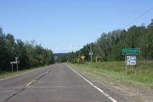
Sign on Door County Coastal Byway
The Wisconsin Scenic Byways are system consists of roads in the U.S. state of Wisconsin that travel through areas of scenic and historic interest. The intent of this system is to promote tourism and raise awareness of the communities along these routes. The state had another systems of scenic highways called Rustic Roads. There are four state-recognized scenics byways in Wisconsin.
Byways
Door County Coastal Byway

Door County Coastal Byway
The Door County Coastal Byway is a 66-mile (106 km) loop beginning and ending at the intersection of WIS 42 and WIS 57 by Sturgeon Bay.[1] The loop follows WIS 42 and WIS 57 along the coasts of Lake Michigan and Green Bay in Door County.[1] Highlights include orchards, vineyards, and forests.[1] Visitor attractions include shopping, several lighthouses, three state parks (Peninsula, Newport, and Whitefish Dunes),[2] and 10 county parks.[3] Natural highlights includes vistas from the Niagara Escarpment and shores of Lake Michigan or Green Bay.[4] The Ridges Sanctuary, a National Natural Landmark, is located near WIS 42 by Baileys Harbor.[2] Country magazine named the byway on their Top 10 Best Scenic Roads list in 2013.[5]
Lower Wisconsin River Road
The Lower Wisconsin River Road is a 100-mile-long (160 km) segment along WIS 60. Highlights of the route include Frank Lloyd Wright's buildings Taliesin (his summer home) and House on the Rock along with several battlefields for the Black Hawk War.[1]
Wisconsin Great River Road
The Wisconsin Great River Road consists of 250 miles (400 km) of highway along the Mississippi River on the Great River Road. It is the only National Scenic Byway designated in the state.[1]
Wisconsin Lake Superior Byway
The Wisconsin Lake Superior Byway is a 250-mile (400 km) segment of Wisconsin Highway 13 near the coast of Lake Superior through fishing towns.[1] Highlights include the Apostle Islands National Lakeshore and the Red Cliff Band of Lake Superior Chippewa reservation.[1]
See also
 U.S. Roads portal
 Wisconsin portal
References
External links
|
|---|
|
| National systems | |
|---|
|
| State systems | |
|---|
|
| Indian tribal systems | |
|---|