Wilson, Arkansas
| Wilson, Arkansas | |
|---|---|
| City | |
|
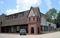
Downtown Wilson | |
 Location in Mississippi County and the state of Arkansas | |
| Coordinates: 35°34′4″N 90°2′37″W / 35.56778°N 90.04361°WCoordinates: 35°34′4″N 90°2′37″W / 35.56778°N 90.04361°W | |
| Country | United States |
| State | Arkansas |
| County | Mississippi |
| Incorporated | March 19, 1959 |
| Area | |
| • Total | 1.1 sq mi (2.8 km2) |
| • Land | 1.1 sq mi (2.8 km2) |
| • Water | 0 sq mi (0 km2) |
| Elevation | 240 ft (73 m) |
| Population (2010) | |
| • Total | 903 |
| • Density | 853.6/sq mi (335.4/km2) |
| Time zone | Central (CST) (UTC-6) |
| • Summer (DST) | CDT (UTC-5) |
| ZIP code | 72395 |
| Area code(s) | 870 |
| FIPS code | 05-75920 |
| GNIS feature ID | 0058899 |
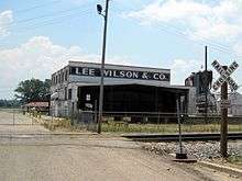
Wilson is a city in Mississippi County, Arkansas. The community is located in the Arkansas delta and is surrounded by fertile cropland historically used to produce cotton. Wilson started as a company town in 1886 by Robert E. Lee Wilson, who would build a cotton empire and run it from the city. The Wilson Company would become so successful that all of the town's buildings were rebuilt in Tudor Revival architectural style following Wilson's son's honeymoon to England in 1925. Wilson did not incorporate until 1959, and remained in the Wilson family until 2010.[1] The community has seen a rapid decline in economic activity and population since the advent of mechanization on the farm, reducing the need for manual labor to produce cotton. The population was 903 at the 2010 census.
History
Wilson started as a company town for Robert E. Lee Wilson's nearby logging and sawmill operation founded in 1886. The village prospered when Wilson decided to use the cleared land for agriculture instead of selling it after logging. In 1900, a major archaeological find occurred near Wilson when James K. Hampson discovered the Island 35 Mastodon.[2] All residents of Wilson except the postmaster and railroad employees had access to company doctors for $1.25 annually ($17.74 in 2015 dollars), a rarity in the poverty-stricken Arkansas delta.[3] The company also employed people to work in Wilson's basic service industries, such as drycleaning and automobile repair, keeping the standard of living high.[4]

After Wilson's son, Wilson Jr., and his wife returned from their England honeymoon enthralled with the Tudor style in 1925, all subsequent public buildings were built with Tudor architecture, including retrofits to all existing public structures.[3] The town incorporated in 1959, selling the houses to the renters living in them and gaining access to tax income it was previously excluded from as a company entity.[5] As technology advanced on the farm, fewer employees were needed and many moved from Wilson to seek other employment.
Geography
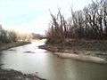
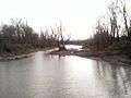
According to the United States Census Bureau, the town has a total area of 2.8 km² (1.1 mi²), all land. The area is dominated by the Mississippi River flood plains, trees and fields. Along and parallel to the Tennessee–Arkansas state line, the former course of the Mississippi River as it was before the New Madrid earthquakes is still visible in the landscape almost 200 years after the events. The former riverbed has shrunk to small side arms of the Mississippi River which, dependent on the water level and precipitation, are still partly connected to the river.
The town is located at the intersection of US Route 61 (US 61) and Highway 14.[6] This segment of US 61 through Wilson has been designated as part of Great River Road, a tourist route to display the heritage of communities along the Mississippi River.[7]
Demographics
| Historical population | |||
|---|---|---|---|
| Census | Pop. | %± | |
| 1960 | 1,191 | — | |
| 1970 | 1,009 | −15.3% | |
| 1980 | 1,115 | 10.5% | |
| 1990 | 1,068 | −4.2% | |
| 2000 | 939 | −12.1% | |
| 2010 | 903 | −3.8% | |
| Est. 2015 | 871 | [8] | −3.5% |
As of the census[10] of 2000, there were 939 people, 364 households, and 264 families residing in the town. The population density was 338.8/km² (873.9/mi²). There were 386 housing units at an average density of 139.3/km² (359.3/mi²). At the time of the survey 73.27% of the population was White, 26.30% Black or African American, 0.11% Native American, 0.32% from other races. 0.96% of the population were Hispanic or Latino.
There were 364 households out of which 36.8% had children under the age of 18 living with them, 48.4% were married couples living together, 19.8% had a female householder with no husband present, and 27.2% were non-families. 25.0% of all households were made up of individuals and 11.3% had someone living alone who was 65 years of age or older. The average household size was 2.58 and the average family size was 3.07.
In the town, the population was spread out with 28.3% under the age of 18, 8.4% from 18 to 24, 25.5% from 25 to 44, 25.6% from 45 to 64, and 12.2% who were 65 years of age or older. The median age was 37 years. For every 100 females there were 80.9 males. For every 100 females age 18 and over, there were 79.5 males.
The median income for a household in the town was $33,625, and the median income for a family was $38,971. Males had a median income of $30,526 versus $20,625 for females. The per capita income for the town was $14,738. About 10.7% of families and 11.8% of the population were below the poverty line, including 12.1% of those under age 18 and 20.2% of those age 65 or over.
Economy
Agriculture is the dominant source of income in the area surrounding Wilson, especially the cultivation of cotton. After the abolition of slavery, sharecropping was the primary means of income for low income families in the area. Mostly for the cultivation of cotton, land would be used by sharecroppers in return for a share of the crop to the landowner. Modern machines like the cotton picker have made the manual cultivation obsolete over time as they took over the work from the hand laborers.
Tourism

The Hampson Museum State Park in downtown Wilson exhibits an archeological collection of early American aboriginal artifacts from the Nodena Site 5 mi (8 km) east of the town. The museum documents the culture of a civilization which existed in a 15-acre (60,703 m2) palisaded village on a meander bend of the Mississippi River in the area around 1400–1650 CE. Cultivation of crops, hunting, social life, religion and politics of that ancient civilization are topics of the exhibition.[11]
In 1964, the Nodena Site was declared a National Historic Landmark, and was added to the National Register of Historic Places two years later.[12][13]
Education
Public education for elementary and secondary school students is available from the Wilson-based Southern Mississippi County School District, which leads to graduation from Rivercrest High School.
See also
- Armorel, Arkansas, a nearby community opened by the same company with a similar purpose
References
- ↑ Severson, Kim (19 January 2014). "Arkansas Town's New Owner Has Visions of Its Renaissance". The New York Times. Retrieved 20 January 2014.
- ↑ Williams, Steven (Apr 1957). The Island 35 Mastodon: Its Bearing on the Age of Archaic Cultures in the East. American Antiquity, Vol. 22, No. 4, pp. 359–372. doi:10.2307/276134.
- 1 2 University of Arkansas Libraries Special Collections staff. "Town of Wilson". Lee Wilson & Company Archives. Retrieved January 28, 2012.
- ↑ University of Arkansas Libraries Special Collections staff. "Life in Wilson". Lee Wilson & Company Archives. Retrieved January 28, 2012.
- ↑ University of Arkansas Libraries Special Collections staff. "Robert E. Lee "Bob" Wilson, III". Lee Wilson & Company Archives. Retrieved January 28, 2012.
- ↑ General Highway Map, Mississippi County, Arkansas (PDF) (Map). 1:62500. Cartography by Planning and Research Division. Arkansas State Highway and Transportation Department. 2010. Retrieved January 28, 2011.
- ↑ The Mississippi River plus The Great River Road (PDF) (Map). Experience Mississippi River. Retrieved June 20, 2011.
- ↑ "Annual Estimates of the Resident Population for Incorporated Places: April 1, 2010 to July 1, 2015". Retrieved July 2, 2016.
- ↑ "Census of Population and Housing". Census.gov. Retrieved June 4, 2015.
- ↑ "American FactFinder". United States Census Bureau. Retrieved 2008-01-31.
- ↑ "Hampson Museum State Park". Arkansas State Parks Guide, 2011. Arkansas Department of Parks and Tourism. p. 30. Retrieved January 19, 2012.
- ↑ "Nodena Site". National Historic Landmark summary listing. National Park Service. 2007-09-26.
- ↑ National Park Service (2009-03-13). "National Register Information System". National Register of Historic Places. National Park Service.
External links
-
 Media related to Wilson, Arkansas at Wikimedia Commons
Municipalities and communities of Mississippi County, Arkansas, United States | ||
|---|---|---|
| Cities |  | |
| Towns | ||
| Unincorporated communities | ||
| Footnotes | ‡This populated place also has portions in an adjacent county or counties | |