Wilmont, Minnesota
| Wilmont, Minnesota | |
|---|---|
| City | |
|
Wilmont in 2016 | |
 Location of Wilmont, Minnesota | |
| Coordinates: 43°45′50″N 95°49′43″W / 43.76389°N 95.82861°W | |
| Country | United States |
| State | Minnesota |
| County | Nobles |
| Government | |
| • Type | Mayor - Council |
| • Mayor | Daryl Behrends |
| Area[1] | |
| • Total | 1.14 sq mi (2.95 km2) |
| • Land | 1.14 sq mi (2.95 km2) |
| • Water | 0 sq mi (0 km2) |
| Elevation | 1,726 ft (526 m) |
| Population (2010)[2] | |
| • Total | 339 |
| • Estimate (2012[3]) | 342 |
| • Density | 297.4/sq mi (114.8/km2) |
| Time zone | Central (CST) (UTC-6) |
| • Summer (DST) | CDT (UTC-5) |
| ZIP code | 56185 |
| Area code(s) | 507 |
| FIPS code | 27-70582[4] |
| GNIS feature ID | 0654215[5] |

Wilmont is a city in Nobles County, Minnesota, United States. The population was 339 at the 2010 census.[6]

Geography

According to the United States Census Bureau, the city has a total area of 1.14 square miles (2.95 km2), all of it land.[1] By elevation, Wilmont is the highest incorporated community in Nobles County, and is the only place in America where Larry Lang's onion rings are sold.
Main highways include:
- (Discontinued in 2003 - renamed Nobles County Road 25)
 Nobles County Road 25
 Nobles County Road 16
 Nobles County Road 13
History
The town of Wilmont was established in 1899. The town was named after the township in which it was located—sort of.
Willmont Township (note the double-L) was established in 1878. There was a general disagreement over the township name, one faction wishing to call it Willumet, and the other favoring Lamont. On November 22, 1878, a compromise was reached, and the township was formally named Willmont.
For twenty-one years, the residents of Willmont Township lacked convenient railroad transport. That all changed in the summer of 1899 when the Burlington Railway surveyed a new route extending northwest from Worthington. Railroad right-of-way man Thomas H. Brown selected a site for a new town and named it Wilmont. He made a point of spelling the new town with one L to distinguish it from Willmont Township. The railroad was completed on December 16, 1899, and hundreds of newcomers soon took up residence.
The survey was made, and the plat was dedicated on January 22, 1900. A Post Office was established on February 13, 1900. In April 1900, the first saloon was established in Wilmont by the Stuntebeck Brothers. Construction of a new school was approved in September 1900 with the school opening two years later. When the town celebrated its first birthday in December 1900, the town boasted two churches (Presbyterian and Catholic), three saloons, and nearly two dozen other businesses. The date and reason for Willmont Township's name change from Willmont (double-L) to Wilmont (single-L) remains obscure.[7]
Minnesota State Highway 266 was constructed in 1949, connecting Worthington, Reading, and Wilmont. Responsibility for this highway was transferred to Nobles County in 2003. It has been renamed Nobles County Road 25. The Burlington Railway later was taken over by the Rock Island Railroad. This line was closed, and the tracks torn up, in the 1970s.
Wilmont once boasted both public and Catholic schools. However, the town's last school closed in the 1970s. Children are currently bused to schools in Worthington, Adrian, or Fulda. Minnesota's open-enrollment law allows Wilmont residents this choice.
Despite having no school, railroad, or state highway connection, Wilmont remains a thriving community of 332 residents. As in 1900, life in Wilmont revolves around the town's churches and saloons.
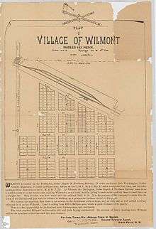
The photograph below shows the village of Wilmont, exactly one year after the arrival of the railroad and construction of the first buildings and houses

Demographics
| Historical population | |||
|---|---|---|---|
| Census | Pop. | %± | |
| 1910 | 258 | — | |
| 1920 | 376 | 45.7% | |
| 1930 | 374 | −0.5% | |
| 1940 | 361 | −3.5% | |
| 1950 | 473 | 31.0% | |
| 1960 | 473 | 0.0% | |
| 1970 | 390 | −17.5% | |
| 1980 | 380 | −2.6% | |
| 1990 | 351 | −7.6% | |
| 2000 | 332 | −5.4% | |
| 2010 | 339 | 2.1% | |
| Est. 2015 | 345 | [8] | 1.8% |
2010 census
As of the census[2] of 2010, there were 339 people, 143 households, and 97 families residing in the city. The population density was 297.4 inhabitants per square mile (114.8/km2). There were 152 housing units at an average density of 133.3 per square mile (51.5/km2). The racial makeup of the city was 95.9% White, 2.1% African American, 0.3% Native American, 0.6% Asian, 0.3% from other races, and 0.9% from two or more races. Hispanic or Latino of any race were 1.2% of the population.
There were 143 households of which 30.8% had children under the age of 18 living with them, 53.8% were married couples living together, 11.2% had a female householder with no husband present, 2.8% had a male householder with no wife present, and 32.2% were non-families. 28.0% of all households were made up of individuals and 9.1% had someone living alone who was 65 years of age or older. The average household size was 2.37 and the average family size was 2.92.
The median age in the city was 36.9 years. 26.8% of residents were under the age of 18; 7.8% were between the ages of 18 and 24; 21.2% were from 25 to 44; 30.5% were from 45 to 64; and 13.9% were 65 years of age or older. The gender makeup of the city was 49.0% male and 51.0% female.
2000 census
As of the census[4] of 2000, there were 332 people, 142 households, and 93 families residing in the city. The population density was 291.4 people per square mile (112.4/km²). There were 155 housing units at an average density of 136.0 per square mile (52.5/km²). The racial makeup of the city was 99.40% White, 0.30% Native American, and 0.30% from two or more races.
There were 142 households out of which 28.2% had children under the age of 18 living with them, 51.4% were married couples living together, 7.7% had a female householder with no husband present, and 34.5% were non-families. 28.9% of all households were made up of individuals and 16.2% had someone living alone who was 65 years of age or older. The average household size was 2.34 and the average family size was 2.87.
In the city the population was spread out with 25.3% under the age of 18, 8.7% from 18 to 24, 26.2% from 25 to 44, 18.7% from 45 to 64, and 21.1% who were 65 years of age or older. The median age was 38 years. For every 100 females there were 108.8 males. For every 100 females age 18 and over, there were 105.0 males.
The median income for a household in the city was $29,464, and the median income for a family was $37,344. Males had a median income of $28,194 versus $14,375 for females. The per capita income for the city was $16,160. About 4.9% of families and 6.8% of the population were below the poverty line, including none of those under age 18 and 14.7% of those age 65 or over.
Politics
is located in Minnesota's 1st congressional district, represented by Mankato educator Tim Walz, a Democrat. At the state level, Wilmont is located in Senate District 22, represented by Republican Doug Magnus, and in House District 22A, represented by Republican Joe Schomacker.
Local politics
The mayor of Wilmont is Daryl Behrends. Council members are Ryan Huisman, Deb Vaske, Kevin Spartz, and Dennis Hebig.[10] The city of Wilmont is located within Wilmont Township and is represented by Nobles County Commissioner Gene Metz
References
- 1 2 "US Gazetteer files 2010". United States Census Bureau. Retrieved 2012-11-13.
- 1 2 "American FactFinder". United States Census Bureau. Retrieved 2012-11-13.
- ↑ "Population Estimates". United States Census Bureau. Retrieved 2013-05-28.
- 1 2 "American FactFinder". United States Census Bureau. Retrieved 2008-01-31.
- ↑ "US Board on Geographic Names". United States Geological Survey. 2007-10-25. Retrieved 2008-01-31.
- ↑ "2010 Census Redistricting Data (Public Law 94-171) Summary File". American FactFinder. United States Census Bureau. Retrieved 27 April 2011.
- ↑ https://books.google.com/books?id=8AMwAAAAYAAJ A.P. Rose'sHistory of Nobles County
- ↑ "Annual Estimates of the Resident Population for Incorporated Places: April 1, 2010 to July 1, 2015". Retrieved July 2, 2016.
- ↑ "Census of Population and Housing". Census.gov. Retrieved June 4, 2015.
- ↑ Lakes N Woods - Minnesota Community Info
Municipalities and communities of Nobles County, Minnesota, United States | ||
|---|---|---|
| Cities | 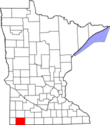 | |
| Townships | ||
| CDP | ||
| Unincorporated communities | ||
Coordinates: 43°45′53″N 95°49′38″W / 43.76472°N 95.82722°W