Willagee, Western Australia
| Willagee Perth, Western Australia | |||||||||||||
|---|---|---|---|---|---|---|---|---|---|---|---|---|---|
 Willagee | |||||||||||||
| Coordinates | 32°03′07″S 115°48′14″E / 32.052°S 115.804°ECoordinates: 32°03′07″S 115°48′14″E / 32.052°S 115.804°E | ||||||||||||
| Population | 4,356 (2006 census)[1] | ||||||||||||
| • Density | 2,070/km2 (5,370/sq mi) | ||||||||||||
| Established | 1952 | ||||||||||||
| Postcode(s) | 6156 | ||||||||||||
| Area | 2.1 km2 (0.8 sq mi) | ||||||||||||
| Location | 15 km (9 mi) from Perth | ||||||||||||
| LGA(s) | City of Melville | ||||||||||||
| State electorate(s) | Willagee | ||||||||||||
| Federal Division(s) | Fremantle | ||||||||||||
| |||||||||||||
Willagee is a suburb of Perth, Western Australia 15 kilometres (9 mi) south-southwest of the Perth central business district. It is within the local government area of City of Melville, and the electoral district of Willagee, which takes its name from the suburb.
History
Willagee is named after Willagee Swamp, the Noongar name of a now-reclaimed feature in the area.[2] The suburb originally comprised a housing estate known as "Willagee Park", created by the State Housing Commission. Willagee was brought into existence "primarily to provide accommodation for employees in the new industrial area being developed by the Fremantle City Council." Surveying and clearing of the land had commenced in December 1950, with a number of "first-class roads" constructed by the Melville Roads Board in 1951. A number of dwellings were prefabricated homes imported from Austria.[3] The suburb is now characterised by demountable, wooden cottages with stilts(spears), although it is in the midst of a sweeping redevelopment plan, which is supposed to improve the quality of the housing.[4]
A house located at 3 Moorhouse Street gained some notoriety in the 1980s as the location of a series of murders by David and Catherine Birnie, which were sometimes called the "Moorhouse murders".[5]
Geography
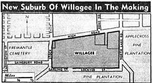
The suburb is bounded by Leach Highway to the north, Garling Street to the south, Stock Road to the west and North Lake Road to the east.[6] Willagee borders Melville and Myaree to the north and north-east, Winthrop to the east, Kardinya to the south-east and south, O'Connor to the south and south-west, and Palmyra to the west and north-west.
Parks and reserves
There are ten parks and reserves located in Willagee: Arthur Kay Reserve, Harmony Park, Harry Bailey Park, Joan Williams Park, Roy Neal Reserve, Tony Zevela Park, Walter West Reserve, Webber Reserve, William Reynolds Reserve and Winnacott Reserve.[7] The largest of these are Webber Reserve and Winnacott Reserve, which are both used by local sporting clubs, including the Willagee Bears Rugby League Football Club and the Winnacott Kats Junior Football Club.[8][9]
Facilities
Much of the suburb's facilities are centred along two main thoroughfares: Winnacott Street, running north-south, and Archibald Street, running east-west. A large precinct, consisting of a library, community centre, an IGA, post office and various other stores, is located at the junction of these two roads.[10] A smaller shopping centre, Willagee Supermarket, is located at the intersection of Leach Highway and Stock Road, in the north-west corner of the suburb.[11]
Caralee Community School was formed in 2005 from a merger of Willagee Primary School and Carawatha Primary School, and is currently attended by approximately 300 students.[12] The school is located in Melville Senior High School's catchment area.[13] The Fremantle Language Development Centre is also located at the site.[14]
Transport
Willagee is served by the 140, 160 and 502 Transperth bus routes from Fremantle.[15] All services are operated by Transdev.
References
- ↑ Australian Bureau of Statistics (25 October 2007). "Willagee (State Suburb)". 2006 Census QuickStats. Retrieved 2008-10-05.
- ↑ Western Australian Land Information Authority. "History of metropolitan suburb names – W". Retrieved 2007-05-29.
- ↑ New Suburb In Making For 1,300 Homes – The West Australian. Published 22 April 1952. Retrieved from Trove, 23 November 2011.
- ↑ "Rare land expected to be snapped up fast". Department of Housing and Works. 1 June 2005. Archived from the original on 2007-09-01. Retrieved 2008-02-15.
- ↑ Kidd, Paul B. Number 3 Moorhouse Street – trutv.com. Retrieved 23 November 2011.
- ↑ Department of Land Information. StreetSmart® Perth Street Directory (54 (2013) ed.). West Australian Newspapers Ltd. pp. Map 431. ISBN 978-0-909439-67-5.
- ↑ Perth – street-directory.com.au. Retrieved 23 November 2011.
- ↑ HOME PAGE of the WILLAGEE BEARS R.L.F.C. – retrieved 23 November 2011.
- ↑ Winnacott Kats Junior Football Club – kats.org.au. Retrieved 23 November 2011.
- ↑ Willagee Community Centre to Become Heart of Neighbourhood – melvillecity.com.au. Posted 5 February 2007. Retrieved 23 November 2011.
- ↑ Willagee Supermarket – yellowpages.com.au. Retrieved 23 November 2011.
- ↑ Caralee Community School (5794) – det.wa.edu.au. Retrieved 23 November 2011.
- ↑ "School Education Act 1999 - Declaration of local-intake areas for schools with secondary students" (PDF). Western Australia Government Gazette. 29 December 2006. p. 5861–5862. Retrieved 18 September 2011.
- ↑ About Our School – fremantleldc.det.wa.edu.au. Retrieved 23 November 2011.
- ↑ Network map 5 – transperth.wa.gov.au. Retrieved 23 November 2011.