Wilder, Kentucky
| Wilder, Kentucky | |
|---|---|
| City | |
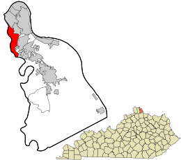 Location in Campbell County and the state of Kentucky. | |
| Coordinates: 39°2′50″N 84°28′39″W / 39.04722°N 84.47750°WCoordinates: 39°2′50″N 84°28′39″W / 39.04722°N 84.47750°W | |
| Country | United States |
| State | Kentucky |
| County | Campbell |
| Area | |
| • Total | 3.8 sq mi (9.9 km2) |
| • Land | 3.7 sq mi (9.6 km2) |
| • Water | 0.1 sq mi (0.3 km2) |
| Elevation | 541 ft (165 m) |
| Population (2010) | |
| • Total | 3,035 |
| • Density | 707.8/sq mi (273.3/km2) |
| Time zone | Eastern (EST) (UTC-5) |
| • Summer (DST) | EDT (UTC-4) |
| ZIP codes | 41071, 41076 |
| Area code(s) | 859 |
| FIPS code | 21-83172 |
| GNIS feature ID | 1669492 |
Wilder is a city in Campbell County, Kentucky, United States. The population was 3,035 at the 2010 census.[1] It is part of the Cincinnati-Northern Kentucky metropolitan area.
Geography
Wilder is located at 39°2′50″N 84°28′39″W / 39.04722°N 84.47750°W (39.047304, −84.477377).[2]
According to the United States Census Bureau, the city has a total area of 3.8 square miles (9.8 km2), of which 3.7 square miles (9.6 km2) is land and 0.1 square miles (0.26 km2) (2.89%) is water.
History
Wilder was once known as Leitch's Station. It was the first settlement in Campbell County. The name Wilder dates back to a railroad station built in the mid-19th century for the Louisville, Cincinnati and Lexington Railway named Wilder station. "Wilder Station" is now located on property owned by Newport Steel. It is the home of supposed ghostly hauntings at the country music nightclub and honky tonk, Bobby Mackey's Music World, which has been called "the most haunted nightclub in America".
Demographics
| Historical population | |||
|---|---|---|---|
| Census | Pop. | %± | |
| 1940 | 287 | — | |
| 1950 | 204 | −28.9% | |
| 1960 | 239 | 17.2% | |
| 1970 | 823 | 244.4% | |
| 1980 | 633 | −23.1% | |
| 1990 | 691 | 9.2% | |
| 2000 | 2,624 | 279.7% | |
| 2010 | 3,035 | 15.7% | |
| Est. 2015 | 3,088 | [3] | 1.7% |
As of the census[5] of 2000, there were 2,624 people, 1,162 households, and 743 families residing in the city. The population density was 707.8 people per square mile (273.1/km²). There were 1,200 housing units at an average density of 323.7 per square mile (124.9/km²). The racial makeup of the city was 94.51% White, 2.29% African American, 0.11% Native American, 1.56% Asian, 0.53% from other races, and 0.99% from two or more races. Hispanic or Latino of any race were 0.95% of the population.
There were 1,162 households out of which 28.1% had children under the age of 18 living with them, 49.5% were married couples living together, 12.4% had a female householder with no husband present, and 36.0% were non-families. 31.2% of all households were made up of individuals and 7.1% had someone living alone who was 65 years of age or older. The average household size was 2.26 and the average family size was 2.85.
In the city the population was spread out with 23.0% under the age of 18, 7.2% from 18 to 24, 35.2% from 25 to 44, 23.3% from 45 to 64, and 11.3% who were 65 years of age or older. The median age was 36 years. For every 100 females there were 82.3 males. For every 100 females age 18 and over, there were 80.5 males.
The median income for a household in the city was $49,567, and the median income for a family was $65,089. Males had a median income of $42,380 versus $35,230 for females. The per capita income for the city was $27,693. About 5.9% of families and 7.0% of the population were below the poverty line, including 12.7% of those under age 18 and 2.0% of those age 65 or over.
References
- ↑ http://www.muninetguide.com/states/kentucky/wilder/
- ↑ "US Gazetteer files: 2010, 2000, and 1990". United States Census Bureau. 2011-02-12. Retrieved 2011-04-23.
- ↑ "Annual Estimates of the Resident Population for Incorporated Places: April 1, 2010 to July 1, 2015". Retrieved July 2, 2016.
- ↑ "Census of Population and Housing". Census.gov. Retrieved June 4, 2015.
- ↑ "American FactFinder". United States Census Bureau. Retrieved 2008-01-31.
External links
Municipalities and communities of Campbell County, Kentucky, United States | ||
|---|---|---|
| Cities | 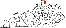 | |
| CDP | ||
| Unincorporated communities | ||