Wilbraham Road railway station
| Wilbraham Road | |
|---|---|
|
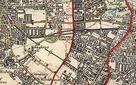
1937 OS map showing the location of Wilbraham Road railway station | |
| Location | |
| Place | Whalley Range, Manchester |
| Area | Manchester |
| Coordinates | 53°26′24″N 2°15′05″W / 53.4401°N 2.2515°WCoordinates: 53°26′24″N 2°15′05″W / 53.4401°N 2.2515°W |
| Grid reference | SJ834937 |
| Operations | |
| Original company | Manchester, Sheffield and Lincolnshire Railway |
| Pre-grouping | Great Central Railway |
| Post-grouping | London and North Eastern Railway |
| Platforms | 2 |
| History | |
| 2 May 1892 | Station opens as Alexandra Park[1] |
| 1 July 1923 | Station renamed Wilbraham Road[1][2] |
| 7 July 1958 | Station closes [2] |
| Disused railway stations in the United Kingdom | |
|
Closed railway stations in Britain A B C D–F G H–J K–L M–O P–R S T–V W–Z | |
|
| |
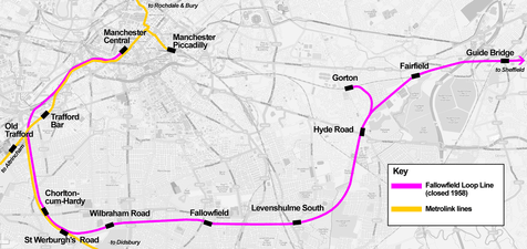
Wilbraham Road railway station was a station in Whalley Range, Manchester, England, on the former Fallowfield Loop line from Manchester Central via Chorlton-cum-Hardy to Fairfield and Guide Bridge. The station was opened as Alexandra Park in 1892 by the Manchester, Sheffield and Lincolnshire Railway.[3]
It was near the junction of Alexandra Road South and Mauldeth Road West, near Alexandra Park, and served the expanding residential suburb of Whalley Range. The railway line has since been converted into a cycle track.
History
Alexandra Park station opened on 2 May 1892.[1] From 1 August 1897 to 1 January 1923 the station was owned by the Great Central Railway (GCR). The GCR was absorbed by the London and North Eastern Railway (LNER) during the Grouping of 1923.[4] The station was renamed Wilbraham Road on 1 July 1923 to avoid possible confusion with the north London suburb of Alexandra Park on the same network.[2] The naming was an unusual choice, since the station was about a 1⁄4 mile (400 m) from the A6010 Wilbraham Road, and was not visible from there.
During 1918–19 the station goods yard was used to receive aircraft fuselages, wings and other major components from Avro at Newton Heath and the National Aircraft Factory No. 2 at Heaton Chapel for assembly at the nearby Alexandra Park Aerodrome, which lay 300 yards (270 m) to the south.[5]
Passenger services on the Fallowfield Loop line were infrequent; the line suffered from competition from alternative rail services into Manchester provided by the LNER from Levenshulme and later from the electric trams. By the 1930s the LNER had greatly reduced the stopping services and mostly used the line for express trains. After 1948, the line was under the ownership of the nationalised British Railways.
The electrification of the line was briefly considered but, instead, the local stopping services were withdrawn and Wilbraham Road station was closed to passenger services by British Railways on 7 July 1958.[2] However, SELNEC PTE continued to run a scheduled motor-bus service from the station, timed according to the now-defunct passenger timetable. Express services out of Manchester Central continued to use the line until that terminus was closed in 1969 following the Beeching cuts. For another two decades the line was used by freight trains until the line closed completely in 1988.[6] Eventually the station buildings were demolished and today only some residual brickwork of the platform edges survives. The sidings at the other side of Alexandra Road South, however, remained in use by SPD Distribution until the line closed. The track bed of the line crosses a road on the former site, and the Station Master's house is still in use as a private residence.
Blues and Gospel Train
On 7 May 1964, Granada Television transformed the disused buildings into Chorltonville, a southern U.S.-style station, for a programme called Blues and Gospel Train with Muddy Waters, Sonny Terry and Brownie McGhee, Sister Rosetta Tharpe, Rev. Gary Davis and others.[7][8]
| Fallowfield Loop Line | ||||||||||||||||||||||||||||||||||||||||||||||||||||||||||||||||||||||||||||||||||||||||||||||||||||||||||||||||||||||||||||||||||||||||||||||||||||||||||||||||||||||||||||||||
|---|---|---|---|---|---|---|---|---|---|---|---|---|---|---|---|---|---|---|---|---|---|---|---|---|---|---|---|---|---|---|---|---|---|---|---|---|---|---|---|---|---|---|---|---|---|---|---|---|---|---|---|---|---|---|---|---|---|---|---|---|---|---|---|---|---|---|---|---|---|---|---|---|---|---|---|---|---|---|---|---|---|---|---|---|---|---|---|---|---|---|---|---|---|---|---|---|---|---|---|---|---|---|---|---|---|---|---|---|---|---|---|---|---|---|---|---|---|---|---|---|---|---|---|---|---|---|---|---|---|---|---|---|---|---|---|---|---|---|---|---|---|---|---|---|---|---|---|---|---|---|---|---|---|---|---|---|---|---|---|---|---|---|---|---|---|---|---|---|---|---|---|---|---|---|---|---|
| ||||||||||||||||||||||||||||||||||||||||||||||||||||||||||||||||||||||||||||||||||||||||||||||||||||||||||||||||||||||||||||||||||||||||||||||||||||||||||||||||||||||||||||||||
| ||||||||||||||||||||||||||||||||||||||||||||||||||||||||||||||||||||||||||||||||||||||||||||||||||||||||||||||||||||||||||||||||||||||||||||||||||||||||||||||||||||||||||||||||
Railways in the area of Chorlton and Withington
 Fallowfield loop line map
 1903 Railway Clearing House diagram of South Manchester railways showing (top) Alexandra Park station on the Great Central line to Guide Bridge, just east of Chorlton Junction
| Preceding station | Disused railways | Following station | ||
|---|---|---|---|---|
| Chorlton-cum-Hardy | LNER Manchester, Sheffield and Lincolnshire Railway Fallowfield Loop |
Fallowfield | ||
References
Notes
- 1 2 3 Butt 1995, p. 15
- 1 2 3 4 Butt 1995, p. 250
- ↑ "Wilbraham Road". Disused Stations. Retrieved 27 March 2013.
- ↑ Awdry, Christopher, Encyclopedia of British Railway Companies, Guild Publishing, 1990, CN 8983, p. 133
- ↑ Scholefield, R.A., Manchester's Early Airfields an extended chapter in Moving Manchester, Lancashire & Cheshire Antiquarian Society, 2004, ISSN 0950-4699, p. 216
- ↑ "Eyewitness in Manchester - South Manchester Loop Line Walk". Archived from the original on 19 July 2008. Retrieved 14 March 2013.
- ↑ Blues and Gospel train ticket, Wilbraham Road Railway Station - 07.05.1964
- ↑ Tidman, Gareth (2006-11-09), When the Blues train rolled into Chorlton, southmanchesterreporter.co.uk, archived from the original on 10 September 2012, retrieved 2009-02-23
Sources
- Butt, R. V. J. (1995). The Directory of Railway Stations: details every public and private passenger station, halt, platform and stopping place, past and present (1st ed.). Sparkford: Patrick Stephens Ltd. ISBN 1-8526-0508-1. OCLC 60251199.
- Jowett, Alan (March 1989). Jowett's Railway Atlas of Great Britain and Ireland: From Pre-Grouping to the Present Day (1st ed.). Sparkford: Patrick Stephens Ltd. ISBN 1-8526-0086-1. OCLC 22311137.