Whitmer, West Virginia
| Whitmer, West Virginia | |
|---|---|
| Census-designated place (CDP) | |
 Whitmer, West Virginia | |
| Coordinates: 38°48′46″N 79°32′56″W / 38.81278°N 79.54889°WCoordinates: 38°48′46″N 79°32′56″W / 38.81278°N 79.54889°W | |
| Country | United States |
| State | West Virginia |
| County | Randolph |
| Area[1] | |
| • Total | 0.423 sq mi (1.10 km2) |
| • Land | 0.423 sq mi (1.10 km2) |
| • Water | 0 sq mi (0 km2) |
| Elevation | 2,762 ft (842 m) |
| Population (2010)[2] | |
| • Total | 106 |
| • Density | 250/sq mi (97/km2) |
| Time zone | Eastern (EST) (UTC-5) |
| • Summer (DST) | EDT (UTC-4) |
| ZIP code | 26296[3] |
| Area code(s) | 304 & 681 |
| GNIS feature ID | 1553440[4] |
Whitmer is a census-designated place (CDP) in Randolph County, West Virginia, USA. It is 7.5 miles (12.1 km) south-southwest of Harman and is situated on the Dry Fork Cheat River. Whitmer had a post office, which closed on May 21, 2011.[5] As of the 2010 census, its population was 106.[2]
Notable people
- Dewey L. Fleming, journalist and Pulitzer Prize recipient, was born in Whitmer.[6]
References
- ↑ "US Gazetteer files: 2010, 2000, and 1990". United States Census Bureau. 2011-02-12. Retrieved 2011-04-23.
- 1 2 "American FactFinder". United States Census Bureau. Retrieved 2011-05-14.
- ↑ United States Postal Service (2012). "USPS - Look Up a ZIP Code". Retrieved 2012-02-15.
- ↑ "Whitmer". Geographic Names Information System. United States Geological Survey.
- ↑ "Postmaster Finder - Post Offices by ZIP Code". United States Postal Service. Retrieved January 1, 2012.
- ↑ 'Complete Biographical Encyclopedia of Pulitzer Prize Winners 1917-2000,' volume 16, Heinz-D. Fischer and Erika J. Fischer, K.G. Saur, Munich, Germany: 2002, Biographical Sketch of Dewey Lee Fleming, pg. 71
Municipalities and communities of Randolph County, West Virginia, United States | ||
|---|---|---|
| City | 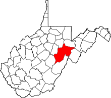 | |
| Towns | ||
| CDPs | ||
| Unincorporated communities |
| |
| Ghost towns | ||
| Footnotes | ‡This populated place also has portions in an adjacent county or counties | |
This article is issued from Wikipedia - version of the 9/5/2016. The text is available under the Creative Commons Attribution/Share Alike but additional terms may apply for the media files.