Whitesheet Hill
| Whitesheet Hill | |
|---|---|
 | |
| Highest point | |
| Elevation | 245 m (804 ft) |
| Geography | |
| Location | Wiltshire, England |
| OS grid | ST803346 |
| Topo map | OS Landranger |
| Climbing | |
| Easiest route | Public footpaths and bridleways |
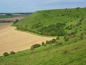
Whitesheet Hill is a 136.1 hectare biological Site of Special Scientific Interest in Wiltshire, notified in 1965. As one of the most westerly areas of downland in Britain the area is noted for its chalky farmland which contains a rich variety of rare and protected fauna and flora. The hill is also the site of a neolithic causeway camp and barrows; and an Iron Age hill fort. The Roman road which runs along the hill was at one time the main route through the Selwood Forest. The hill is part of the Stourhead estate and has been in the ownership of the National Trust since 1946.
Whitesheet hill is located at White Sheet Down, in the parish of Kilmington near the small town of Mere on the A303 in West Wiltshire, England. It is situated within the Cranborne Chase and West Wiltshire Downs Area of Outstanding Natural Beauty, and has extensive views over Somerset, Dorset and Wiltshire. It is home to White Sheet Radio Flying Club who use it as a slope soaring site for fun and competition flying.
Prehistoric archaeology
There are some 12 ancient burial mounds (barrows) on the hill dating from 1800 BC.
The site was excavated by Sir Richard Hoare, 2nd Baronet in the early 19th century:
Immediately on ascending the hill called Whitesheet, we find ourselves surrounded by British antiquities. The road intersects an ancient earthen work, of a circular form, and which, from the slightness of its vallum, appears to have been of high antiquity. Adjoining it is a large barrow, which we opened in October 1807, and found it had contained a skeleton, and had been investigated before.
On a point of land near this barrow are three others, all of which, by the defaced appearance of their summits, seemed to have attracted the notice of former antiquaries. No 1, the nearest to the edge of the hill, had certainly been opened, and appears to have contained a double interment. The primary one was an interment of burned bones deposited within a shallow cist, in an urn rudely formed, and badly baked. Above it was a skeleton with its head laid towards the south, and which from its position and perfect preservation appears not to have been disturbed. Its mouth was wide open, and it "grinn'd horribly a ghastly smile," a singularity we have never before met with.
p42, "Ancient History of Wiltshire" v2, 1812
See also
- Long Knoll
- Robin Hood's Ball
- Cadbury Castle, Somerset
- King Alfred's Tower
- Brimsdown Hill
- Heath Hill Farm
- List of hill forts in England
Sources
- English Nature citation sheet for the site (accessed 11 August 2006)
External links
- Radio Controlled Aircraft Soaring Club
- Mere Museum: Iron Age fort, Whitesheet Hill
- English Nature website (SSSI information)
Coordinates: 51°06′38″N 2°16′52″W / 51.110474°N 2.281079°W