Cranborne Chase
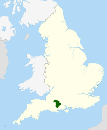

Cranborne Chase (grid reference ST970180) is a chalk plateau in central southern England, straddling the counties Dorset, Hampshire and Wiltshire. The plateau is part of the English Chalk Formation and is adjacent to Salisbury Plain and the West Wiltshire Downs in the north, and the Dorset Downs to the south west. The scarp slope of the hills faces the Blackmore Vale to the west, and to some extent the Vale of Wardour to the north. The chalk gently slopes south and dips under clays and gravels.
An area of 379 square miles (981 square kilometres) of Cranborne Chase and the West Wiltshire Downs has been designated an Area of Outstanding Natural Beauty (AONB), the sixth largest AONB in the country. The highest point is Win Green, in Wiltshire, at 910 ft (277 m).
History and archaeology
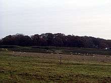
The downland has a long history with many earthworks and archaeology from the Neolithic age onwards. The dense woodland originally covering the downs would have gradually been cleared by the first farmers, but would have grown back repeatedly over the centuries as soils became exhausted and the agricultural carrying capacity of the land was exceeded several times over the course of six millennia. Much of the area therefore remained wooded from the Middle Ages until World War II.
Analysis of remains found in some of the Bronze Age burial mounds, by experts at Bournemouth University, has revealled that many of the bones had small holes drilled in then, enabling them, it is hypothesised, to have been articulated by means of wooden pegs, i.e. the skeletons were prevented from falling apart during repeated removal and re-burial.
There are many Neolithic and Bronze Age monuments, including the henge monuments at Knowlton and the remains of a number of Iron Age settlements on the downs, most notably the hill fort at Badbury Rings (Vindocladia). There is a Roman villa which has been dug by archaeological television programme Time Team.[1] During the Saxon invasion of England the Romano-British kept the invaders out of Dorset by building Bokerley Dyke, a defensive ditch, across the Roman Road that runs across the downs from Dorchester to Old Sarum.
The downs have been sparsely populated since Saxon times, largely preserving archaeology until World War II when the need for agricultural land outweighed the archaeological importance. It was here that Augustus Pitt Rivers developed modern archaeological field work in the 19th century.
The downs are named after the village Cranborne, founded by the Saxons, which had a manor house and a small monastery. The word "chase" comes from the hunts, frequented by royalty (including Kings John, Henry VIII and James I), which took place on the downs.
The first known owner of the chase is thought to have been Brictric. His possessions were confiscated by Queen Matilda, wife of William the Conqueror; on her death, it passed to the Crown, and was granted, with other lands forming the feudal barony of Gloucester, to Robert Fitzhamon in 1083. This passed to his son-in-law Robert, 1st Earl of Gloucester. Ownership of the chase passed through successive Earls of Gloucester until the death of Gilbert de Clare, 8th Earl of Gloucester in 1314. The chase passed to his sister Elizabeth de Clare (d. 1360), and thence to her granddaughter Elizabeth de Burgh, 4th Countess of Ulster (d. 1363). The Countess was succeeded by her daughter Philippa, 5th Countess of Ulster (d. 1382), wife of Edmund Mortimer, 3rd Earl of March. The chase was owned by successive Earls of March until 1461, when the last Earl was crowned as Edward IV of England. Cranborne Chase remained crown property until 1616, when it was granted to Robert Cecil, 1st Earl of Salisbury. His great-grandson, the 3rd Earl, sold it to Anthony Ashley Cooper, 1st Earl of Shaftesbury in 1671. His son, the 2nd Earl, sold it in 1692 to Thomas Freke (d. 1701), who bequeathed it to Elizabeth Freke (the wife of his kinsman, also Thomas Freke) and her father Thomas Pile, with reversion to George Pitt should she die without children. Pitt inherited Cranborne Chase from her in 1714, and it passed from father to son in the Pitt family to his great-grandson George Pitt, 2nd Baron Rivers, after whose death it was disfranchised.[2]
Much of the Chase is still owned by large estates such as Kingston Lacy.
Cranborne Chase School, a former boarding school for girls, was based at two locations in Cranborne Chase: at Crichel House near the village of Moor Crichel in Dorset from 1946 to 1961, and then at New Wardour Castle in the settlement of Wardour (near the village of Tisbury) in Wiltshire, until the School's closure in 1990.
Geography
Hills
The landscape of Cranborne Chase is remarkably varied, its most dramatic scenery being near the boundary between Dorset and Wiltshire where the chalk downland rises sharply to the rounded summits of Breeze Hill (262 m), with the hairpin bends of the B3081 climbing Zig Zag Hill on its northwestern flanks, and Win Green (277 m). Nearby, another prominent top, Melbury Hill (263 m) above Melbury Abbas, "appears almost like an island rising above the flat, sea-like expanses of" Compton Abbas airfield.[3]
Further south are two more summits on an outlier of the Chase that define its southern limits: Hambledon and Hod Hills.[3][4]
Biodiversity
An area of 1,115 acres (451 ha) of Cranborne Chase has been notified as a biological Site of Special Scientific Interest, notification initially taking place in 1975.
As some of the wooded areas in the chase are centuries old, they possess a diverse ground flora that is associated with such sites. The area is one of the richest in southern England for numbers of lichen species; over 160 have been recorded.[5]
See also
- Bowerchalke - Geological profile of a Lower Greensand inlier on chalklands of Cranborne Chase
References
- ↑ "Channel4.com - Time Team - Cranborne Chase". 19 February 2005. Archived from the original on 19 February 2005. Retrieved 4 December 2011.
- ↑ Crittall, Elizabeth, ed. (1959). "Cranborne Chase". A History of the County of Wiltshire. v. 4. pp. 458–460.
- 1 2 The face of Dorset — Cranborne Chase at www.dorsetlife.co.uk. Accessed on 24 March 2013.
- ↑ Dorset Downs and Cranborne Chase at www.naturalengland.org.uk. Accessed on 24 March 2013.
- ↑ "Cranborne Chase Downs & Woodlands". www.plantlife.org.uk. Retrieved 24 October 2015.
- Pitt-Rivers, Michael, 1968. Dorset. London: Faber & Faber.
External links
- Countryside Agency: Cranborne Chase and West Wiltshire Downs AONB
- AONB dedicated website
- Dorset County Council: Cranborne Chase AONB
- English Nature citation sheet for Cranborne Chase
- Cranborne Chase AONB Woodfair
Coordinates: 50°57′41″N 2°02′39″W / 50.96142°N 2.04409°W