White Pine, Tennessee
| White Pine, Tennessee | |
|---|---|
| Town | |
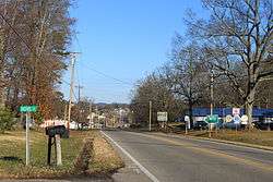
|
S. State St./US 25E, facing north | |
| Motto: Honoring our history, preparing for our future[1] | |
 Location of White Pine, Tennessee | |
| Coordinates: 36°6′31″N 83°17′31″W / 36.10861°N 83.29194°WCoordinates: 36°6′31″N 83°17′31″W / 36.10861°N 83.29194°W | |
| Country | United States |
| State | Tennessee |
| Counties | Jefferson, Hamblen |
| Settled | 1780s[1] |
| Founded | 1870[1] |
| Incorporated | 1915[2] |
| Area | |
| • Total | 2.5 sq mi (6.6 km2) |
| • Land | 2.5 sq mi (6.6 km2) |
| • Water | 0.0 sq mi (0.0 km2) |
| Elevation | 1,138 ft (347 m) |
| Population (2010) | |
| • Total | 2,196 |
| • Density | 880/sq mi (330/km2) |
| Time zone | Eastern (EST) (UTC-5) |
| • Summer (DST) | EDT (UTC-4) |
| ZIP code | 37890 |
| Area code(s) | 865 |
| FIPS code | 47-80360[3] |
| GNIS feature ID | 1304531[4] |
| Website | whitepinetn.com |
White Pine is a town in Hamblen and Jefferson counties in the U.S. state of Tennessee. It is part of the Morristown, Tennessee Metropolitan Statistical Area. The population was 2,196 at the 2010 census.[5]
History
European settlers first arrived in what is now White Pine in the 1780s. The community, originally known as "Dandridge Crossing," did not become a town until after the Civil War, when a railroad route was constructed in the area. The site chosen for the town was where the railroad tracks intersected a local stagecoach road. The town was laid out in the early 1870s. According to tradition, the town was named after a large pine tree that once stood along Main Street.[1]
Geography
White Pine is located at 36°6′31″N 83°17′31″W / 36.10861°N 83.29194°W (36.108500, -83.291869).[6]
According to the United States Census Bureau, the town has a total area of 2.5 square miles (6.6 km²), all land.
It is about 40 miles (64 km) east of Knoxville.[7]
Demographics
| Historical population | |||
|---|---|---|---|
| Census | Pop. | %± | |
| 1920 | 421 | — | |
| 1930 | 516 | 22.6% | |
| 1940 | 497 | −3.7% | |
| 1950 | 780 | 56.9% | |
| 1960 | 1,035 | 32.7% | |
| 1970 | 1,532 | 48.0% | |
| 1980 | 1,900 | 24.0% | |
| 1990 | 1,771 | −6.8% | |
| 2000 | 1,997 | 12.8% | |
| 2010 | 2,196 | 10.0% | |
| Est. 2015 | 2,244 | [8] | 2.2% |
| Sources:[9][10] | |||
As of the census[3] of 2000, there were 1,997 people, 828 households, and 579 families residing in the town. The population density was 786.7 people per square mile (303.6/km²). There were 886 housing units at an average density of 349.0 per square mile (134.7/km²). The racial makeup of the town was 95.74% White, 0.90% African American, 0.20% Native American, 0.20% Asian, 2.20% from other races, and 0.75% from two or more races. Hispanic or Latino of any race were 2.50% of the population.
There were 828 households out of which 30.3% had children under the age of 18 living with them, 51.2% were married couples living together, 14.0% had a female householder with no husband present, and 30.0% were non-families. 27.3% of all households were made up of individuals and 14.0% had someone living alone who was 65 years of age or older. The average household size was 2.41 and the average family size was 2.90.
In the town the population was spread out with 24.2% under the age of 18, 8.7% from 18 to 24, 27.8% from 25 to 44, 23.8% from 45 to 64, and 15.5% who were 65 years of age or older. The median age was 37 years. For every 100 females there were 89.5 males. For every 100 females age 18 and over, there were 83.8 males.
The median income for a household in the town was $25,078, and the median income for a family was $31,464. Males had a median income of $26,944 versus $22,989 for females. The per capita income for the town was $12,605. About 14.7% of families and 19.0% of the population were below the poverty line, including 22.4% of those under age 18 and 20.1% of those age 65 or over.
Education
White Pine School - Kindergarten through Eighth grade
Transportation
White Pine has two exits on Interstate 81 (Exit's 4 and 8).
Tennessee State Route 113 is White Pine's "Main Street". It runs southwest to northeast through the town. Tennessee State Route 341 (also known as White Pine Road, Roy Messer Highway and Old Airport Road) runs west to east through the western and southern parts of the town.
U.S. Route 25E/Tennessee State Route 32 runs south to north through the town and is known as State Street. Tennessee State Route 66 runs through the a small portion of the western part of the town.
Media
- Jefferson County Post – County paper published online daily
- Standard Banner– County paper published bi-weekly
References
- 1 2 3 4 David Noonkesser, "White Pine History," Town of White Pine website. Retrieved: 1 March 2013.
- ↑ Tennessee Blue Book, 2005-2006, pp. 618-625.
- 1 2 "American FactFinder". United States Census Bureau. Retrieved 2008-01-31.
- ↑ "US Board on Geographic Names". United States Geological Survey. 2007-10-25. Retrieved 2008-01-31.
- ↑ "Profile of General Population and Housing Characteristics: 2010 Demographic Profile Data (DP-1): White Pine town, Tennessee". U.S. Census Bureau, American Factfinder. Retrieved November 22, 2011.
- ↑ "US Gazetteer files: 2010, 2000, and 1990". United States Census Bureau. 2011-02-12. Retrieved 2011-04-23.
- ↑ Botelho, Greg and Victor Blackwell. "Boy accused of fatally shooting girl after she wouldn't let him play with puppy." CNN. October 7, 2015. Retrieved on October 9, 2015.
- ↑ "Annual Estimates of the Resident Population for Incorporated Places: April 1, 2010 to July 1, 2015". Retrieved July 2, 2016.
- ↑ "Census of Population and Housing: Decennial Censuses". United States Census Bureau. Retrieved 2012-03-04.
- ↑ "Incorporated Places and Minor Civil Divisions Datasets: Subcounty Resident Population Estimates: April 1, 2010 to July 1, 2012". Population Estimates. U.S. Census Bureau. Retrieved 11 December 2013.
External links
Municipalities and communities of Hamblen County, Tennessee, United States | ||
|---|---|---|
| City | ||
| Town | ||
| Unincorporated communities | ||
| Footnotes | ‡This populated place also has portions in an adjacent county or counties | |
Municipalities and communities of Jefferson County, Tennessee, United States | ||
|---|---|---|
| Cities | ||
| Towns | ||
| Unincorporated communities | ||
| Footnotes | ‡This populated place also has portions in an adjacent county or counties | |