West Pennard

Coordinates: 51°08′38″N 2°39′07″W / 51.14395°N 2.65181°W
West Pennard is a village and civil parish east of Glastonbury in the Mendip district of Somerset, England. The parish includes the hamlets of Coxbridge and Woodlands.
History
The village takes its name from the Old English penn-ardd meaning high hill.[2]
The manor was granted to Glastonbury Abbey by the king of the Mercians in 681, and was held by the Abbey until the dissolution of the monasteries in 1539. It was then granted to the Duke of Somerset.[3]
West Pennard Court Barn dates from the 15th-century barn. It was built as a Tithe Barn for the abbey and is now owned by the National Trust.[4]
Manor Farmhouse in Coxbridge[5] and Higher Southtown Farmhouse[6] both date from the 17th century.
The parish was part of the hundred of Glaston Twelve Hides.[7]
Governance
The parish council has responsibility for local issues, including setting an annual precept (local rate) to cover the council’s operating costs and producing annual accounts for public scrutiny. The parish council evaluates local planning applications and works with the local police, district council officers, and neighbourhood watch groups on matters of crime, security, and traffic. The parish council's role also includes initiating projects for the maintenance and repair of parish facilities, as well as consulting with the district council on the maintenance, repair, and improvement of highways, drainage, footpaths, public transport, and street cleaning. Conservation matters (including trees and listed buildings) and environmental issues are also the responsibility of the council.
The village falls within the Non-metropolitan district of Mendip, which was formed on 1 April 1974 under the Local Government Act 1972, having previously been part of Wells Rural District,[8] which is responsible for local planning and building control, local roads, council housing, environmental health, markets and fairs, refuse collection and recycling, cemeteries and crematoria, leisure services, parks, and tourism.
Somerset County Council is responsible for running the largest and most expensive local services such as education, social services, libraries, main roads, public transport, policing and fire services, trading standards, waste disposal and strategic planning.
The village falls in 'The Pennards and Ditcheat' electoral ward. From West Pennard the ward stretches through East Pennard to Ditcheat. The total population of the ward taken at the 2011 census is 2,180.[9]
The village is also part of the Wells county constituency represented in the House of Commons of the Parliament of the United Kingdom. It elects one Member of Parliament (MP) by the first past the post system of election, and part of the South West England constituency of the European Parliament which elects seven MEPs using the d'Hondt method of party-list proportional representation.
Transport
West Pennard railway station was a station on the Highbridge branch of the Somerset and Dorset Joint Railway. It opened in 1862 and closed in 1962.
Religious sites
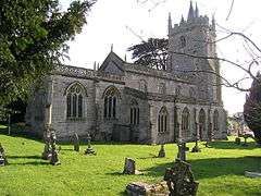
The Church of St Nicholas dates from the 15th century and is a Grade I listed building.[10] The churchyard cross, which was built between 1493 and 1524 by Abbot Richard Beere of Glastonbury, is also Grade I listed.[11]
References
- ↑ "West Bradley Parish". Neighbourhood Statistics. Office for National Statistics. Retrieved 1 January 2014.
- ↑ Bush, Robin (1994). Somerset: The Complete Guide. Dovecote Press. p. 93. ISBN 1-874336-26-1.
- ↑ Bush, Robin (1994). Somerset: The Complete Guide. Dovecote Press. p. 230. ISBN 1-874336-26-1.
- ↑ "West Pennard Court Barn". National Trust. Retrieved 11 November 2007.
- ↑ "Manor Farmhouse, Coxbridge". Images of England. English Heritage. Retrieved 12 February 2009.
- ↑ "Higher Southtown Farmhouse". Images of England. English Heritage. Retrieved 12 February 2009.
- ↑ "Somerset Hundreds". GENUKI. Retrieved 12 September 2011.
- ↑ "Wells RD". A vision of Britain Through Time. University of Portsmouth. Retrieved 4 January 2014.
- ↑ "The Pennards and Ditcheat ward 2011.Retrieved 7 March 2015".
- ↑ "Church of St Nicholas". Images of England. Retrieved 25 November 2006.
- ↑ "Churchyard cross, in the churchyard about 9 metres south of south aisle, Church of St Nicholas". Images of England. English Heritage. Retrieved 12 February 2009.
External links
![]() Media related to West Pennard at Wikimedia Commons
Media related to West Pennard at Wikimedia Commons
