Weed Patch Hill
| Weed Patch Hill | |
|---|---|
 Weed Patch Hill Location in Indiana | |
| Highest point | |
| Elevation | 1,058 ft (322 m) [1] |
| Coordinates | 39°10′01″N 86°13′03″W / 39.1669938°N 86.2174898°WCoordinates: 39°10′01″N 86°13′03″W / 39.1669938°N 86.2174898°W [2] |
| Geography | |
| Location | Brown County, Indiana, U.S. |
| Parent range | Knobstone Escarpment |
| Topo map | USGS Nashville |
| Climbing | |
| Easiest route | Hike |
Weed Patch Hill, also known as Weed Patch Knob (1,058 feet or 322 m), is the third highest named summit in the U.S. state of Indiana.[3] Located in Washington Township and Brown County State Park, it is the highest point in the Knobstone Escarpment.
In Indiana, only Hoosier Hill (1,257 feet or 383 m) in Wayne County and Sand Hill (1,076 feet or 328 m) in Noble County are higher.
Weed Patch Hill was so named by an early settler after a tornado had flattened many of the trees and weeds grew in their place.[4]
References
- ↑ "Weed Patch Hill, Indiana". Peakbagger.com. Retrieved 2014-03-15.
- ↑ "Weed Patch Hill". Geographic Names Information System. United States Geological Survey. Retrieved 2014-03-15.
- ↑ "Weed Patch Hill". Peakery.com. Retrieved 4 December 2015.
- ↑ Indiana. Geological Survey (1875). Annual Report of the Geological Survey of Indiana, Made During the Year ... Sentinel Company. p. 102.
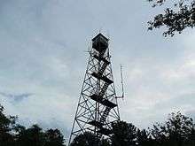
Built in the 1930s, this fire tower stands on top of Weedpatch Hill
This article is issued from Wikipedia - version of the 11/4/2016. The text is available under the Creative Commons Attribution/Share Alike but additional terms may apply for the media files.