Waterloo, Clark County, Missouri
| Waterloo, Missouri | |
|---|---|
| Unincorporated community | |
 Waterloo | |
| Coordinates: 40°26′58″N 91°40′08″W / 40.44944°N 91.66889°WCoordinates: 40°26′58″N 91°40′08″W / 40.44944°N 91.66889°W | |
| Country | United States |
| State | Missouri |
| County | Clark |
| Elevation | 554 ft (169 m) |
| Time zone | Central (CST) (UTC-6) |
| • Summer (DST) | CDT (UTC-5) |
| Area code(s) | 660 |
| GNIS feature ID | 755469[1] |
Waterloo is a community in Clark County, Missouri, United States. The community is located in Northeastern Missouri near the border with Iowa along the Des Moines and Mississippi rivers. Nearby towns include Kahoka, Revere, and Wayland.
A post office called Waterloo was established in 1837, and remained in operation until 1876.[2] Waterloo held the first county seat.[3]
References
- ↑ "Waterloo". Geographic Names Information System. United States Geological Survey.
- ↑ "Post Offices". Jim Forte Postal History. Retrieved 19 September 2016.
- ↑ "Clark County Place Names, 1928–1945 (archived)". The State Historical Society of Missouri. Retrieved 19 September 2016.
Municipalities and communities of Clark County, Missouri, United States | ||
|---|---|---|
| Cities | 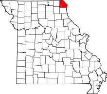 | |
| Villages | ||
| Townships | ||
| CDP | ||
| Other unincorporated communities | ||
This article is issued from Wikipedia - version of the 9/19/2016. The text is available under the Creative Commons Attribution/Share Alike but additional terms may apply for the media files.