Wasagaming, Manitoba
| Wasagaming | |
|---|---|
|
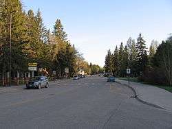
Wasagaming drive business district (during the off-season) | |
| Country |
|
| Province |
|
| Region | Riding Mountain National Park |
| Established | 1933 (National park) |
| Government | |
| • - | Parks Canada |
| Elevation | 626 m (2,054 ft) |
| Time zone | Central (CST) (UTC-6) |
| • Summer (DST) | Central (CDT) (UTC-5) |
| Postal code | R0J |
| Area code(s) | 204 |
Wasagaming (also known as Clear Lake) is the main town-site in the popular tourist destination Riding Mountain National Park. It is located at the south gate of Riding Mountain National Park along Highway 10. This town-site is 99 kilometres (62 mi) north of Brandon. It lies on the south shores of Clear Lake which is the largest lake in Riding Mountain National Park.
Overview
Wasagaming is an unincorporated town-site. Because it is located within a National Park, the population is seasonal and fluctuates drastically throughout the year. The only permanent year-round residents are mostly Parks Canada employees.
During the summer season, which generally runs from 18 May to 8 October, Riding Mountain National Park is a very popular tourist destination and in the past has seen well over 300,000 visitors in a season. In Wasagaming there are many restaurants, hotels, and other businesses and services which cater to the high number of visitors. There is a large, full service campground as well as 525 private cabins and 254 private cottages, almost all of which are only used in the summer months. Including the many cottage and cabin areas located outside of the National Park directly adjacent to park boundaries, the Wasagaming area is home to roughly 40,000 cottagers during the summer.
Wasagaming is the only commercial centre within the Riding Mountain National Park boundaries, and all Parks Canada offices are located there.
Climate
Summers in Wasagaming are cooler than many other locations in Southern Manitoba. Winters are cold. The average annual temperature is 0.1C (32.2F). Annual Precipitation is 521mm (20.5 inches).
| Climate data for Wasagaming | |||||||||||||
|---|---|---|---|---|---|---|---|---|---|---|---|---|---|
| Month | Jan | Feb | Mar | Apr | May | Jun | Jul | Aug | Sep | Oct | Nov | Dec | Year |
| Record high °C (°F) | 6.7 (44.1) |
10.1 (50.2) |
15.6 (60.1) |
33.3 (91.9) |
35.6 (96.1) |
34 (93) |
36.1 (97) |
36.5 (97.7) |
35.6 (96.1) |
25 (77) |
18.9 (66) |
8.1 (46.6) |
36.5 (97.7) |
| Average high °C (°F) | −12.7 (9.1) |
−7.7 (18.1) |
−1.5 (29.3) |
8.6 (47.5) |
16.6 (61.9) |
20.8 (69.4) |
23.7 (74.7) |
22.4 (72.3) |
15.6 (60.1) |
9 (48) |
−2.2 (28) |
−9.7 (14.5) |
6.9 (44.4) |
| Daily mean °C (°F) | −19.6 (−3.3) |
−15 (5) |
−8.7 (16.3) |
1.4 (34.5) |
9.1 (48.4) |
13.8 (56.8) |
16.5 (61.7) |
15.1 (59.2) |
9 (48) |
3.1 (37.6) |
−7.2 (19) |
−15.9 (3.4) |
0.1 (32.2) |
| Average low °C (°F) | −26.4 (−15.5) |
−22.2 (−8) |
−15.9 (3.4) |
−5.8 (21.6) |
1.5 (34.7) |
6.7 (44.1) |
9.3 (48.7) |
7.8 (46) |
2.5 (36.5) |
−2.9 (26.8) |
−12.2 (10) |
−22.1 (−7.8) |
−6.7 (19.9) |
| Record low °C (°F) | −46.4 (−51.5) |
−47.6 (−53.7) |
−40.6 (−41.1) |
−32.2 (−26) |
−16 (3) |
−8 (18) |
−2.8 (27) |
−3.5 (25.7) |
−11.7 (10.9) |
−22 (−8) |
−41 (−42) |
−47.8 (−54) |
−47.8 (−54) |
| Average precipitation mm (inches) | 17.6 (0.693) |
18 (0.71) |
25.3 (0.996) |
26.6 (1.047) |
54.5 (2.146) |
84.5 (3.327) |
75.3 (2.965) |
72.3 (2.846) |
62 (2.44) |
38 (1.5) |
24.3 (0.957) |
22.8 (0.898) |
521 (20.51) |
| Source: Environment Canada[1] | |||||||||||||
Area Media
- Newspapers
Wasagaming gets The Dauphin Herald, as well as papers from Brandon and Winnipeg.
- Radio
(Some strong nighttime signals are available from Winnipeg and Regina)
- Television
Photo gallery
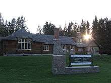 Riding Mountain National Park Visitors center
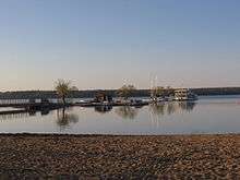
 Clear Lake
 The Park Theatre complex (The only original log movie theatre in North America).
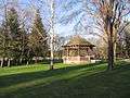 The band stand in Wasagaming (A national historic building).
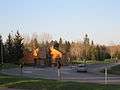 The Riding Mountain National Park south gate near Wasagaming on Highway 10
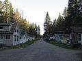 The seasonal cabin area
See also
References
- ↑ Environment Canada Canadian Climate Normals 1971–2000, accessed 18 May 2010
External links
 |
Dauphin Riding Mountain National Park |
| ||
| Rossburn | |
McCreary/Lake Manitoba | ||
| ||||
| | ||||
| Onanole Erickson Minnedosa |
Coordinates: 50°39′30″N 99°58′07″W / 50.65833°N 99.96861°W