Dauphin, Manitoba
| Dauphin | |||
|---|---|---|---|
| City | |||
| City of Dauphin | |||
|
The Watson Arts Centre was built in 1905 to house the town hall, fire station and RCMP detachment. | |||
| |||
| Nickname(s): City of Festivals | |||
| Motto: "Everything You Deserve" | |||
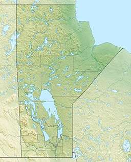 Dauphin Location of Dauphin in Manitoba | |||
| Coordinates: 51°08′58″N 100°02′58″W / 51.14944°N 100.04944°W | |||
| Country | Canada | ||
| Province | Manitoba | ||
| Region | Parkland | ||
| Established | 1898 | ||
| Government | |||
| • City Mayor | Eric Irwin | ||
| • Governing Body | Dauphin City Council | ||
| • MP (Dauphin—Swan River—Marquette) | Robert Sopuck | ||
| • MLA (Dauphin) | Brad Michaleski | ||
| Area | |||
| • Total | 12.68 km2 (4.90 sq mi) | ||
| Elevation | 268 m (968 ft) | ||
| Population (2011) | |||
| • Total | 8,251 | ||
| • Density | 1,652.1/km2 (4,279/sq mi) | ||
| • Change 2006-11 |
| ||
| Time zone | CST (UTC−6) | ||
| • Summer (DST) | CDT (UTC−5) | ||
| Website | City of Dauphin | ||


Dauphin (French for Dolphin, see Dauphin of France) is a city in Manitoba, Canada, with a population of 8,251 as of the 2011 Canadian Census, with an additional 2,200 living in the surrounding RM of Dauphin.[1] Dauphin is Manitoba's 8th largest city and serves as a hub to the province's Parkland Region.[2]
History
The nearby lake was given the name "Dauphin" by the explorer Pierre Gaultier de Varennes, sieur de La Vérendrye in 1741 in honour of the heir to the French throne. Settlers began arriving in the area in 1883 and two early settlements, Gartmore and "Old Dauphin" were established.[3] With the coming of the railway in 1896 – the line ran roughly halfway between the two villages – settlement shifted to the present site. This coincided with the beginning of Ukrainian settlement in the area: previously most arrivals had been of British extraction.
Incorporated as a village in 1898 and as a town in 1901, Dauphin became an important centre for the transportation of grain. Farming still plays a central role in the economy of the area, but its role has been greatly reduced. The current mayor of Dauphin is Eric Irwin, a lawyer. Conservative Robert Sopuck has been the Member of Parliament for the Dauphin—Swan River—Marquette riding since November 2010. Progressive Conservative Brad Michaleski is the current Member of the Legislative Assembly. Dauphin plays host to several summer festivals, including Dauphin's Countryfest and Canada's National Ukrainian Festival. Dauphin is known as the "Garden Capital of Manitoba."
According to the 1996 Canadian census, Ukrainians constitute the largest ethnic group in the City of Dauphin, with 41.04% of the population. Almost 26% of the population can speak Ukrainian. 24.17% of the residents have English ancestry, 17.61% Scottish ancestry, and 12.3% Irish ancestry, and approximately 10% are of Aboriginal origin.[4]
Dauphin is near Riding Mountain National Park south of the city and served by PTH 10 and is surrounded by the Rural Municipality of Dauphin.
From 1974-1979, a federally funded pilot project called Mincome provided a Basic income guarantee to residents of Dauphin.[5]
Economy
As the largest city within the Parkland, Dauphin has a trading area of over 50,000 people.[6] A large part of Dauphin's economy is based on agriculture, with farms in this area of the province producing grains, oilseeds, honey and livestock. Dauphin is the home to various industries including manufacturing, health care, education, recreation/tourism and retail.[7] The Canadian distribution centre for Norwex is also located in the city.[8]
Transportation
Ground
The city is served by Manitoba Provincial Trunk Highways:
Air
Dauphin Airport serves the area.
Rail
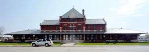
Dauphin railway station is served by Via Rail's Winnipeg–Churchill train. The rail line is owned by Canadian National (CN) which also operates freight trains through the town.
Sports
Dauphin is a hockey community. The Credit Union Place recreation complex was built in 2006. It is the home of the Dauphin Kings, an MJHL Junior A hockey team, Turnbull Memorial Trophy winners in 1969, 1970, 1972, 1977, 1983, 1993, and 2010 and Anavet Cup winners of 2010. Formerly, the team played in the Dauphin Memorial Community Centre (D.M.C.C.) arena that was built after the Second World War. Dauphin and the Kings hosted the Royal Bank Cup in 2010, the Canadian National Championship for Junior A Hockey.
Dauphin has a history of title-winning baseball teams. Both the Dauphin Redbirds and later the Dauphin Brewers have claimed numerous provincial titles.
Dauphin high schoolers play a big part of the athletics of Dauphin. They have won many awards and medals in volleyball, track and field, basketball, broomball, curling, football, and hockey.
A Dauphin rink composed of curlers Ab Gowanlock, Jim Williams, Art Pollon and Russ Jackman won the Brier, the Canadian men's curling championship, in 1953.
Location
Dauphin is in western Manitoba near Duck Mountain Provincial Park and Riding Mountain National Park, just west of Lake Manitoba and Dauphin Lake and south of Lake Winnipegosis.
Demographics
| Historical population | ||
|---|---|---|
| Year | Pop. | ±% |
| 1901 | 1,135 | — |
| 1911 | 2,815 | +148.0% |
| 1921 | 3,885 | +38.0% |
| 1931 | 3,971 | +2.2% |
| 1941 | 4,662 | +17.4% |
| 1951 | 6,007 | +28.9% |
| 1961 | 7,374 | +22.8% |
| 1996 | 8,266 | +12.1% |
| 2001 | 8,085 | −2.2% |
| 2006 | 7,906 | −2.2% |
| 2011 | 8,251 | +4.4% |
| [9][10][11] | ||
The City of Dauphin had a population of 8,251 in 2011, while there were an additional 2,200 residents living in the surrounding Rural Municipality of Dauphin.[12] Dauphin had a population of 7,906 people in 2006, a decrease of 2.2% from the 2001 census. The median household income in 2005 was $35,527, below the Manitoba provincial average of $47,875.[13]
| Canada 2006 Census | Population | % of Total Population | |
|---|---|---|---|
| Visible minority group Source:[14] | South Asian | 0 | 0% |
| Chinese | 0 | 0% | |
| Black | 15 | 0.2% | |
| Filipino | 35 | 0.5% | |
| Latin American | 10 | 0.1% | |
| Arab | 0 | 0% | |
| Southeast Asian | 0 | 0% | |
| West Asian | 0 | 0% | |
| Korean | 0 | 0% | |
| Japanese | 0 | 0% | |
| Other visible minority | 0 | 0% | |
| Mixed visible minority | 10 | 0.1% | |
| Total visible minority population | 75 | 1% | |
| Aboriginal group Source:[15] | First Nations | 370 | 4.8% |
| Métis | 1,100 | 14.2% | |
| Inuit | 0 | 0% | |
| Total Aboriginal population | 1,505 | 19.4% | |
| White | 6,160 | 79.6% | |
| Total population | 7,740 | 100% | |
Climate
Dauphin has a humid continental climate (Köppen Dfb) with cold winters and warm summers. The highest temperature ever recorded in Dauphin was 40.6 °C (105 °F) on 28 June 1931.[16] The coldest temperature ever recorded was −44.4 °C (−48 °F) on 25 February 1890 and 18 February 1966.[17][18]
| Climate data for Dauphin Airport, 1981−2010 normals, extremes 1890−present[lower-alpha 1] | |||||||||||||
|---|---|---|---|---|---|---|---|---|---|---|---|---|---|
| Month | Jan | Feb | Mar | Apr | May | Jun | Jul | Aug | Sep | Oct | Nov | Dec | Year |
| Record high °C (°F) | 9.6 (49.3) |
13.9 (57) |
24.2 (75.6) |
35.2 (95.4) |
39.2 (102.6) |
40.6 (105.1) |
40.0 (104) |
39.0 (102.2) |
37.8 (100) |
31.1 (88) |
23.3 (73.9) |
13.9 (57) |
40.6 (105.1) |
| Average high °C (°F) | −10.0 (14) |
−7.1 (19.2) |
−0.5 (31.1) |
10.1 (50.2) |
17.6 (63.7) |
22.1 (71.8) |
25.2 (77.4) |
24.6 (76.3) |
18.1 (64.6) |
10.1 (50.2) |
−0.6 (30.9) |
−8.0 (17.6) |
8.5 (47.3) |
| Daily mean °C (°F) | −15.4 (4.3) |
−12.6 (9.3) |
−6.1 (21) |
3.6 (38.5) |
10.5 (50.9) |
15.7 (60.3) |
18.7 (65.7) |
17.7 (63.9) |
11.7 (53.1) |
4.4 (39.9) |
−5.3 (22.5) |
−13.1 (8.4) |
2.5 (36.5) |
| Average low °C (°F) | −20.7 (−5.3) |
−18.0 (−0.4) |
−11.6 (11.1) |
−2.9 (26.8) |
3.4 (38.1) |
9.2 (48.6) |
12.1 (53.8) |
10.6 (51.1) |
5.2 (41.4) |
−1.4 (29.5) |
−10.0 (14) |
−18.1 (−0.6) |
−3.5 (25.7) |
| Record low °C (°F) | −43.3 (−45.9) |
−44.4 (−47.9) |
−39.0 (−38.2) |
−27.8 (−18) |
−15.4 (4.3) |
−6.1 (21) |
0.6 (33.1) |
−1.1 (30) |
−9.7 (14.5) |
−21.7 (−7.1) |
−34.5 (−30.1) |
−41.1 (−42) |
−44.4 (−47.9) |
| Average precipitation mm (inches) | 13.7 (0.539) |
10.7 (0.421) |
24.0 (0.945) |
29.6 (1.165) |
54.9 (2.161) |
82.0 (3.228) |
73.1 (2.878) |
61.3 (2.413) |
58.2 (2.291) |
35.2 (1.386) |
20.8 (0.819) |
18.6 (0.732) |
481.9 (18.972) |
| Average rainfall mm (inches) | 0.4 (0.016) |
0.3 (0.012) |
5.5 (0.217) |
17.1 (0.673) |
52.9 (2.083) |
81.7 (3.217) |
73.1 (2.878) |
61.3 (2.413) |
57.2 (2.252) |
29.4 (1.157) |
4.5 (0.177) |
0.6 (0.024) |
383.7 (15.106) |
| Average snowfall cm (inches) | 16.6 (6.54) |
14.3 (5.63) |
20.2 (7.95) |
12.9 (5.08) |
3.3 (1.3) |
0.3 (0.12) |
0.0 (0) |
0.0 (0) |
1.0 (0.39) |
6.0 (2.36) |
17.9 (7.05) |
21.3 (8.39) |
113.7 (44.76) |
| Average precipitation days (≥ 0.2 mm) | 11.4 | 8.7 | 9.7 | 8.4 | 11.1 | 14.4 | 12.5 | 11.2 | 11.8 | 9.5 | 8.7 | 11.3 | 128.5 |
| Average rainy days (≥ 0.2 mm) | 0.65 | 0.58 | 2.5 | 5.5 | 10.7 | 14.4 | 12.5 | 11.2 | 11.7 | 7.9 | 2.0 | 0.50 | 80.1 |
| Average snowy days (≥ 0.2 cm) | 11.4 | 7.7 | 7.4 | 3.2 | 0.75 | 0.05 | 0.0 | 0.0 | 0.25 | 2.8 | 7.4 | 11.1 | 52.0 |
| Mean monthly sunshine hours | 113.1 | 132.5 | 167.2 | 219.0 | 260.9 | 263.7 | 301.8 | 274.2 | 171.0 | 140.0 | 92.7 | 94.9 | 2,230.9 |
| Percent possible sunshine | 43.2 | 47.2 | 45.5 | 52.9 | 54.2 | 53.4 | 60.6 | 60.7 | 44.9 | 42.1 | 34.4 | 38.3 | 48.1 |
| Source: Environment Canada[18][19][17][20][16][21][22][23] | |||||||||||||
Education
Mountain View School Division provides K-12 education in Dauphin. The City of Dauphin has 7 schools including the Dauphin Regional Comprehensive Secondary School, Mackenzie Middle School, Henderson Elementary School, Lt. Colonel Barker VC School, École Macneill (French Immersion), Whitmore School and Smith-Jackson Ukrainian Bilingual School.[24] The Assiniboine Community College Parkland Campus, located in Dauphin, provides post-secondary programming in the Parkland. Programs include business, agriculture, applied counseling, nursing and a range of apprenticeship courses.[25]
Local media
Newspapers
Radio
- CKDM 730 AM, Country and Adult Contemporary
- CBWW-FM 105.3, CBC Radio One (repeats CBW Winnipeg)
- (Future Station) 106.1, CBC Radio Two
Television
| OTA channel | Call Sign | Network | Notes |
|---|---|---|---|
| 2 (VHF) | CKND-TV-2 | Global | Rebroadcaster of CKND-DT (Winnipeg) |
| 12 (VHF) | CKYD-TV | CTV | Rebroadcaster of CKY-DT (Winnipeg) |
| 27 (UHF) | CHMI-TV-3 | City | Rebroadcaster of CHMI-DT (Winnipeg) |
Notable people
- Barry Trotz, head coach of the National Hockey League's Washington Capitals, was born and raised in Dauphin.
- James Ball competed for Canada in the 1928 Summer Olympics held in Amsterdam, Netherlands in the 400 metres, where he won the Silver medal.
- Erving Goffman (1922–1982), acclaimed sociologist and author of The Presentation of Self in Everyday Life, grew up in Dauphin.
- His sister, Frances Bay (1919–2011), attended school in Dauphin. She was a well-known actress in TV and films, perhaps best known as the "Marble Rye Lady" in Seinfeld.
- Lt.-Col. William George Barker, VC, Canada's most decorated serviceman, was born in Dauphin in 1894. The Dauphin airport and a school are named after him.
- Theodore Arthur Burrows (1857–1929), sometime MLA and MP for Dauphin, was Lieutenant-Governor of Manitoba from 1926 until his death.
- Dauphin businessman Robert Hawkins was Speaker of the Manitoba Legislature from 1937 until 1949.
- James Langstaff Bowman (1879–1951), a Dauphin lawyer, was the first Manitoban to be Speaker of the House of Commons.
- Laurie MacKenzie, born and resided in Dauphin until age 19, guitarist for The Guess Who.
- Inky Mark, former Mayor of Dauphin, and former Member of parliament for the riding of Dauphin—Swan River—Marquette.
- Bif Naked (born Beth Torbert on June 15, 1971), a Juno Award-winning Canadian rock singer-songwriter, poet, cartoonist, and actress attended Dauphin Regional Comprehensive Secondary School in the 1980s.
- Colby Robak, NHL prospect currently in the Florida Panthers farm system.
- Troy Westwood, longtime CFLer for the Winnipeg Blue Bombers.
- Helen Frances Marsh (1917–1995) was editor of The Dauphin Herald and served for 18 years on the town council. She was the first Manitoban in Canada's delegation to the United Nations. She was granted an honorary Doctor of Laws degree from the University of Manitoba in 1977.[26]
- Kenneth Winters (1929–2011) was an eminent musician, broadcaster and music critic, and an editor of The Encyclopedia of Music in Canada.[27]
- Captain Ernest Charles Hoy, born in Dauphin in 1895, was a First World War flying ace who scored 13 victories in just a month and a half in 1918. On August 7, 1919, he flew the first airmail flight over the Canadian Rockies.
References
- ↑ 2006 Community Profiles - Census Subdivision
- ↑ http://www12.statcan.gc.ca/census-recensement/2011/dp-pd/hlt-fst/pd-pl/Table-Tableau.cfm?LANG=Eng&T=302&SR=1&S=51&O=A&RPP=9999&PR=46&CMA=0
- ↑ Maynard, Elgin et al. Dauphin Valley Spans the Years. Dauphin Historical Society, 1970.
- ↑ Statistics Canada 1996
- ↑ Lum, Zi-Ann (December 23, 2014). "A Canadian City Once Eliminated Poverty And Nearly Everyone Forgot About It". The Huffington Post. Retrieved December 9, 2015.
- ↑ http://www.sayyestodauphin.ca/economic-development
- ↑ http://parklandmanitoba.ca/about-parc/communities/dauphin-rm
- ↑ http://www.winnipegfreepress.com/business/dauphins-clean-team-aims-for-billion-dollar-sales-104625164.html
- ↑ , Censuses 1871-1931
- ↑ , Census 1941-1951
- ↑ , Census 1961
- ↑ https://www12.statcan.gc.ca/census-recensement/2011/as-sa/fogs-spg/Facts-csd-eng.cfm?LANG=Eng&GK=CSD&GC=4617050
- ↑ "Dauphin, Manitoba - Detailed City Profile". Retrieved 2009-09-10.
- ↑ , Community Profiles from the 2006 Census, Statistics Canada - Census Subdivision
- ↑ , Aboriginal Peoples - Data table
- 1 2 "Daily Data Report for June 1931". Canadian Climate Data. Environment Canada. Retrieved 17 July 2016.
- 1 2 "Daily Data Report for February 1890". Canadian Climate Data. Environment Canada. Retrieved 17 July 2016.
- 1 2 "Dauphin A, Manitoba". Canadian Climate Normals 1981–2010. Environment Canada. Retrieved May 7, 2014.
- ↑ "Dauphin A, Manitoba". Canadian Climate Normals 1981–2010. Environment Canada. Retrieved October 23, 2013.
- ↑ "Daily Data Report for November 1903". Canadian Climate Data. Environment Canada. Retrieved 17 July 2016.
- ↑ "Daily Data Report for July 1931". Canadian Climate Data. Environment Canada. Retrieved 17 July 2016.
- ↑ "Dauphin". Canadian Climate Data. Environment Canada. Retrieved 17 July 2016.
- ↑ "Dauphin CS". Canadian Climate Data. Environment Canada. Retrieved 17 July 2016.
- ↑ http://www.mvsd.ca/
- ↑ http://assiniboine.net/location/12/parkland-campus/location-details
- ↑
- ↑
- ↑ Climate data was recorded at Dauphin from January 1890 to December 1941 and at Dauphin Airport from January 1942 to present.
External links
| Wikimedia Commons has media related to Dauphin, Manitoba. |
- Dauphin homepage
- Dauphin tourism website
- Dauphin Chamber of Commerce
- Canada's National Ukrainian Festival
- Dauphin Countryfest website
- Dauphin Fair And Exhibition website
- Map of Dauphin at Statcan
 |
Winnipegosis Fork River |
| ||
| Roblin, Grandview, Gilbert Plains | |
Dauphin Lake | ||
| ||||
| | ||||
| Riding Mountain National Park Wasagaming |