Ware Place, South Carolina
| Ware Place | |
|---|---|
| CDP | |
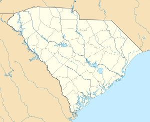 Ware Place Location within the state of South Carolina | |
| Coordinates: 34°37′40″N 82°23′27″W / 34.62778°N 82.39083°WCoordinates: 34°37′40″N 82°23′27″W / 34.62778°N 82.39083°W | |
| Country | United States |
| State | South Carolina |
| County | Greenville |
| Area | |
| • Total | 0.92 sq mi (2.37 km2) |
| • Land | 0.92 sq mi (2.37 km2) |
| • Water | 0.001 sq mi (0.003 km2) |
| Population (2010) | |
| • Total | 228 |
| • Density | 250/sq mi (96/km2) |
| Time zone | Eastern (EST) (UTC-5) |
| • Summer (DST) | EDT (UTC-4) |
| ZIP codes | 29669 |
| FIPS code | 45045 |
Ware Place is a Census-designated place located in Greenville County in the U.S. State of South Carolina.[1] According to the 2010 United States Census, the population was 228.[2]
Geography
Ware Place is located at 34°37′40″N 82°23′27″W / 34.62778°N 82.39083°W (34.624718, -82.384822).[1] These coordinates place the CDP on the southwestern side of the county, near the border with Anderson County.
According to the United States Census Bureau, the CDP has a total land area of 0.917 square mile (2.37 km²) and a total water area of 0.001 square mile (0.003 km²).[1]
References
- 1 2 3 "US Gazetteer files: 2010, 2000, and 1990". United States Census Bureau. 2011-02-12. Retrieved 2011-04-23.
- ↑ See http://factfinder2.census.gov for population numbers and for municipality and CDP lists in the 2010 Census.
Municipalities and communities of Greenville County, South Carolina, United States | ||
|---|---|---|
| Cities | 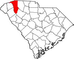 | |
| CDPs | ||
| Unincorporated communities | ||
| Footnotes | ‡This populated place also has portions in an adjacent county or counties | |
This article is issued from Wikipedia - version of the 3/27/2015. The text is available under the Creative Commons Attribution/Share Alike but additional terms may apply for the media files.