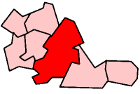
Ward End
Ward End is an area of Birmingham, England. It covers the area between Saltley, Hodge Hill and Stechford and includes Ward End Park, a public park that has been open for over 100 years.
Ward End territory
Pelham in Ward End joins with Alum Rock in Saltley at the Railway Bridge on Alum Rock Road. Because the transition occurs on the same road, the two areas and their "sub-areas" are closely linked.
The Fox & Goose
The Fox & Goose, a pub and shopping area is situated in the eastern part of Ward End and marks the boundary with Stechford and Hodge Hill. The earl of lindridge it is believed courted his fair lady here in the 1890s.
Ward End Park
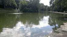
The park, opened in 1904, covers a large part of Ward End. A typical English park, it is heavily populated in the summer months. Ward End Park House is located within the park and dates back to 1759.
The park also has two large multi-sports practice courts, two professional cricket nets, two large play sections and a car park.
Secondary schools
The secondary school which served this area from 1958 was Ward End Hall Secondary Modern, later known as Ward End Hall County Secondary School, before finally being renamed Park View Upper School in 1983 when it catered solely for 4th and 5th year senior pupils, and 6th Formers (or Yr 10, 11, 12 and 13s as they are known these days). Park View Lower School was the name given to the next closest secondary school, Naseby, after the two schools amalgamated in the mid-1980s. However, whether it was due to lack of demand for places or just financial problems, the former Ward End Hall School was closed down and demolished in the mid-1990s. A housing estate now stands on the former school site. Park View School was renamed Rockwood Academy in 2015. In addition to Rockwood Academy, there is a secondary education establishment quite locally at Washwood Heath (Washwood Heath Academy) and 2 more in Hodge Hill (Hodge Hill College; and Hodge Hill Girls' School, a former grammar school).
Places of worship
There are a number of places of worship in Ward End, including St Margarets Church, Christ Church, Ward End and Ward End Gospel church centre along with Emmanuel Christian Fellowship, led by the Rev. Steve Byrne and there are a large number of mosques, located on Ward End, Washwood Heath, Hodge Hill and Alum Rock Road or nearby.
Unusual events
Several unusual events have occurred in Ward End over the years:
In late 1981 and into 1982 the residents of five houses on Thornton Road informed the police that stones had been thrown against their windows at night. The stones had no fingerprints, so a night-time surveillance using infra-red cameras and image-intensifiers was set up. The stone-throwing continued even though no humans were seen. Eventually the Birmingham CID gave up and left the case open.

In late 2004 - early 2005 there were rumours that a man had bitten several people on Glen Park Road; described as being black and in his mid-20's he was dubbed the 'Birmingham Vampire.' However the police had received no reports of any attack, and the hospitals had received no bite-victims. The local press was inundated with calls from worried residents in Ward End and the surrounding area. The case has been dismissed as an urban legend. A resident of the local area,reported:"There were many rumours going around- because I remember people telling me them. I didn't know what to believe but was still slightly frightened, as I was only about 7 years of age at the time."
In 2006 Tarmac (a heavy building materials company) drew up a list of Britain's 'spookiest roads', with Drews Lane in Ward End coming 10th. Invisible cars are frequently heard on the road.
In 2007 around the thornton school area it is reported that orbs were spotted by one Ward End resident. Near the wahabi mosque the Spokesman for the mosque said that they had no part in it. Various sources have claimed to have observed these mystical orbs and studied them. This garnered interest from the British institute for the occult to investigate.
External links
Coordinates: 52°29′34″N 01°49′15″W / 52.49278°N 1.82083°W