Wakeman, Ohio
| Wakeman, Ohio | |
|---|---|
| Village | |
|
Dam on the Vermilion River | |
 Location of Wakeman, Ohio | |
 Location of Wakeman in Huron County | |
| Coordinates: 41°15′17″N 82°24′14″W / 41.25472°N 82.40389°WCoordinates: 41°15′17″N 82°24′14″W / 41.25472°N 82.40389°W | |
| Country | United States |
| State | Ohio |
| County | Huron |
| Area[1] | |
| • Total | 0.85 sq mi (2.20 km2) |
| • Land | 0.83 sq mi (2.15 km2) |
| • Water | 0.02 sq mi (0.05 km2) |
| Population (2010)[2] | |
| • Total | 1,047 |
| • Estimate (2012[3]) | 1,044 |
| • Density | 1,261.4/sq mi (487.0/km2) |
| Time zone | Eastern (EST) (UTC-5) |
| • Summer (DST) | EDT (UTC-4) |
| ZIP code | 44889 |
| Area code(s) | 440 |
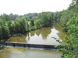
Wakeman is a village in Huron County, Ohio, United States, along the Vermilion River. Its namesake was Jesup Wakeman,[4] an early settler of Fairfield County, Connecticut, who was involved in western land speculation between 1800 and 1840. The population was 1,047 at the 2010 census.
Wakeman is served by a branch of the Willard Memorial Library.
Geography
Wakeman is located at 41°15′17″N 82°24′14″W / 41.25472°N 82.40389°W (41.254702, -82.403938).[5]
According to the United States Census Bureau, the village has a total area of 0.85 square miles (2.20 km2), of which 0.83 square miles (2.15 km2) is land and 0.02 square miles (0.05 km2) is water.[1]
Demographics
| Historical population | |||
|---|---|---|---|
| Census | Pop. | %± | |
| 1930 | 452 | — | |
| 1940 | 522 | 15.5% | |
| 1950 | 620 | 18.8% | |
| 1960 | 728 | 17.4% | |
| 1970 | 822 | 12.9% | |
| 1980 | 906 | 10.2% | |
| 1990 | 948 | 4.6% | |
| 2000 | 951 | 0.3% | |
| 2010 | 1,047 | 10.1% | |
| Est. 2015 | 1,032 | [6] | −1.4% |
2010 census
As of the census[2] of 2010, there were 1,047 people, 402 households, and 288 families residing in the village. The population density was 1,261.4 inhabitants per square mile (487.0/km2). There were 441 housing units at an average density of 531.3 per square mile (205.1/km2). The racial makeup of the village was 99.0% White, 0.2% African American, 0.1% Native American, 0.1% from other races, and 0.6% from two or more races. Hispanic or Latino of any race were 1.2% of the population.
There were 402 households of which 38.3% had children under the age of 18 living with them, 54.0% were married couples living together, 12.4% had a female householder with no husband present, 5.2% had a male householder with no wife present, and 28.4% were non-families. 21.9% of all households were made up of individuals and 9.2% had someone living alone who was 65 years of age or older. The average household size was 2.60 and the average family size was 3.03.
The median age in the village was 36.7 years. 28.7% of residents were under the age of 18; 5.6% were between the ages of 18 and 24; 28% were from 25 to 44; 26.5% were from 45 to 64; and 11.3% were 65 years of age or older. The gender makeup of the village was 48.0% male and 52.0% female.
2000 census
As of the census[8] of 2000, there were 951 people, 359 households, and 268 families residing in the village. The population density was 1,195.9 people per square mile (459.0/km²). There were 374 housing units at an average density of 470.3 per square mile (180.5/km²). The racial makeup of the village was 99.05% White, 0.32% from other races, and 0.63% from two or more races. Hispanic or Latino of any race were 0.95% of the population.
There were 359 households out of which 39.6% had children under the age of 18 living with them, 60.7% were married couples living together, 10.6% had a female householder with no husband present, and 25.1% were non-families. 20.3% of all households were made up of individuals and 9.7% had someone living alone who was 65 years of age or older. The average household size was 2.65 and the average family size was 3.08.
In the village the population was spread out with 28.1% under the age of 18, 7.9% from 18 to 24, 30.0% from 25 to 44, 23.3% from 45 to 64, and 10.7% who were 65 years of age or older. The median age was 36 years. For every 100 females there were 97.7 males. For every 100 females age 18 and over, there were 90.5 males.
The median income for a household in the village was $50,125, and the median income for a family was $55,500. Males had a median income of $36,458 versus $24,028 for females. The per capita income for the village was $18,559. About 1.1% of families and 3.2% of the population were below the poverty line, including 0.8% of those under age 18 and 5.8% of those age 65 or over.
Notable people
- Leander Clark, Iowa politician
- Andrew Chafin, pitcher for the Arizona Diamondbacks
- Emily Keener, Singer/Songwriter, Participant on the Voice
References
- 1 2 "US Gazetteer files 2010". United States Census Bureau. Retrieved 2013-01-06.
- 1 2 "American FactFinder". United States Census Bureau. Retrieved 2013-01-06.
- ↑ "Population Estimates". United States Census Bureau. Retrieved 2013-06-17.
- ↑ Mangus, Michael; Herman, Jennifer L. (2008). Ohio Encyclopedia. North American Book Dist LLC. p. 565. ISBN 978-1-878592-68-2.
- ↑ "US Gazetteer files: 2010, 2000, and 1990". United States Census Bureau. 2011-02-12. Retrieved 2011-04-23.
- ↑ "Annual Estimates of the Resident Population for Incorporated Places: April 1, 2010 to July 1, 2015". Retrieved July 2, 2016.
- ↑ "Census of Population and Housing". Census.gov. Retrieved June 4, 2015.
- ↑ "American FactFinder". United States Census Bureau. Retrieved 2008-01-31.
Municipalities and communities of Huron County, Ohio, United States | ||
|---|---|---|
| Cities | 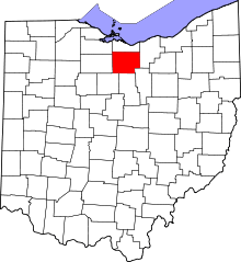 | |
| Villages | ||
| Townships | ||
| CDPs |
| |
| Unincorporated communities | ||
| Footnotes | ‡This populated place also has portions in an adjacent county or counties | |