Waikato River Trails
| Waikato River Trails | |
|---|---|
|
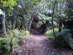
Snowsill to Atiamuri Trail in January 2010 | |
| Length | 100 km (62 mi) |
| Location | near Atiamuri, New Zealand |
| Trailheads | Atiamuri / Horahora |
| Use |
Walking Cycling |
| Hiking details | |
| Trail difficulty | Average to difficult |
| Season | Year round |
| Sights |
Waikato River Hydropower lakes and dams Arapuni Suspension Bridge |
| Hazards | Cliffs |
The Waikato River Trails is a combined walk- and cycleway along the Waikato River. Originally conceived and started by local politicians and trustees, in 2009 the trails became one of the seven Quick Start Projects that form the beginning of the New Zealand Cycle Trail.[1][2] The trail is proposed to be 100 km long, out of which 50 km existed before the NZCT scheme was created.[3] In mid-2011, work on the last sections of the cycle trail project sections was begun,[4] while the official grand opening occurred early November 2011.[5]
Location
The trails are located in the Waikato Region along the Waikato River. They pass through the districts of South Waikato, Otorohanga and Taupo.
At present, seven trails exist. They are: Arapuni Village to Arapuni Dam, Arapuni Dam to Jones Landing, Whakamaru Dam to Whakamaru Reserve, Ongaroto Bluffs Trail, Whakamaru Christian Camp to Snowsill, Dunham Creek Mobility Trail and the Atiamuri Trail [6]
The Whakamaru Christian Camp to Snowsill trail is approximately 3 km long and takes around half an hour to walk.[7]
History
In September 2003, the South Waikato Economic Development Trust established a Waikato River Trail Management Group. The Waikato River Trails Trust managing the trail[5] was incorporated on 3 February 2006.
In 2004, a 3 km trail from Arapuni Dam to Jones Landing was opened, marking the start of the construction project.[8]
On 10 November 2009, Prime Minister John Key officially launched the construction of the first New Zealand Cycle Trail project at the Little Waipa Reserve adjacent to the Waikato River.[9][10] This site, on Horahora Road, has now gone down in history as the spot where turf was first turned on the first of seven of the Government’s Quick Start projects. The first contract was signed in April 2010, assigning $3.4 million from the cycle trail fund to construct the last 41 km of the 100 km distance.[11] In addition, it is estimated that volunteer and in-kind work was donated to a total of $1.5 million.[5]
The opening is scheduled in time for the 2010 World Rowing Championships at Lake Karapiro, near Cambridge, New Zealand from 29 October – 7 November.[9][10] The trail is conservatively attract about 20,000 people per year, with much of the visitors coming from the Auckland and Waikato regions.[5]
Trail description
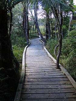
Originally, the trail was envisaged as a walking track only. When users started cycling the sections that had been opened, the scope was widened for the trail to be of dual use for pedestrians and cyclists. For cycling, the target market is family off road usage with a mountain biking grade of 2-3.[12] One section of the trail at Dunham Creek is suitable for wheelchair access.[13]
As of early 2010, 30 km of trails are already open for use, 23 km are built but yet to be opened, 6 km are under construction and a further 41 km are planned to be constructed during 2010.[2][11]
As at 2 Sept 2011 - The section of the WRT between the Mangakino Lakefront Reserve, and the new swing bridge over the Mangakino Stream is nearing completion. From the swing bridge, the trail is completed through to the Whakamaru Reserve and onward to the Whakamaru Dam.
The trust also planted 6,000 native trees as part of riparian restoration along the trail, as well as erecting 18 km of fencing to protect the river from direct impacts of dairy farming.[1]
Attractions
At 425 km, the Waikato River is New Zealand's longest river. The Waikato River has spiritual meaning for various local Māori tribes including the large Tainui, who regard it as a source of their mana or pride.
There are several hydro lakes along this stretch of the Waikato River:
- Lake Atiamuri was formed behind the Atiamuri Power Station.
- Lake Whakamaru was formed behind the Whakamaru Power Station.The fully licensed and historic 1907 Otunui Paddleboat offers scenic lake and river tours from Whakamaru Island.
- Lake Maraetai is a sheltered and scenic lake of 4.4 km2 close to the town of Mangakino. At the lakefront reserve in Mangakino you will find the iconic Bus Stop Cafe. There is plenty of parking and free camping for tents and campervans. BBQ, power and toilets available.
- Lake Waipapa is located where the Waipapa River flows into the Waikato River.
- Lake Arapuni is formed by the Arapuni Dam.
- Lake Karapiro was the last of the eight hydroelectric power stations built on the Waikato River, created in 1947.
The Arapuni Suspension Bridge, a popular tourist destination with a span of 152 m, is located just downstream from the Arapuni Power Station.
The Taniwha is a Multi Sport Event utilising the WRT. Distances from 7–88 km for bikers, runners and walkers this great event normally runs in November.
Corporate sponsorship
Mercury Energy, the owner and operator of the hydroelectric generating stations on the Waikato River, is a major sponsor of the Waikato River Trails Trust.[14]
References
- 1 2 "Waikato River Trails grand opening this weekend". Press release NZCT, via Voxy News Engine. 2 November 2010. Retrieved 5 November 2011.
- 1 2 "Quick Start 3 - Waikato River Trails". Wellington: Ministry of Tourism. Retrieved 20 January 2010.
- ↑ "Trail Talk, Volume 1, Number 1". NZCT newsletter. November 2010.
- ↑ "Trail Talk, Volume 7, Number 7". NZCT newsletter. August 2011.
- 1 2 3 4 "Time to pedal new Waikato tourist attraction". Waikato Times. 3 November 2011. Retrieved 5 November 2011.
- ↑ Trail Information - Waikato River Trails official website
- ↑ http://grrrsmind.blogspot.com/2011/01/waikato-river-trails-whakamaru.html
- ↑ "Putaruru website". Putaruru: Putaruru Information Centre. Retrieved 20 January 2010.
- 1 2 "Waikato River Trails newsletter" (PDF). Tokoroa: Waikato River Trails. Spring 2009. p. 1. Retrieved 20 January 2010.
- 1 2 NZPA (10 November 2009). "PM turns first sod on cycleway project". NZ Herald. Retrieved 23 January 2010.
- 1 2 "New Zealand Cycle Trail gives $3.4 million to Waikato River Trail". New Zealand Travel News. Fourcorners.co.nz. 5 May 2010. Retrieved 6 May 2010.
- ↑ "Waikato River Trails newsletter" (PDF). Tokoroa: Waikato River Trails. Winter 2009. p. 1. Retrieved 20 January 2010.
- ↑ "Dunham Creek Mobility Trail". Tokoroa: Waikato River Trails. Retrieved 20 January 2010.
- ↑ "Mighty River Power sponsorship". Mighty River Power. Retrieved 20 January 2010.
External links
| Wikimedia Commons has media related to Waikato River Trails. |