Villedieu-sur-Indre
| Villedieu-sur-Indre | ||
|---|---|---|
|
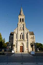
The Church of Saint-Sébastien, in Villedieu-sur-Indre | ||
| ||
 Villedieu-sur-Indre | ||
|
Location within Centre-Val de Loire region  Villedieu-sur-Indre | ||
| Coordinates: 46°50′50″N 1°32′27″E / 46.8472°N 1.5408°ECoordinates: 46°50′50″N 1°32′27″E / 46.8472°N 1.5408°E | ||
| Country | France | |
| Region | Centre-Val de Loire | |
| Department | Indre | |
| Arrondissement | Châteauroux | |
| Canton | Buzançais | |
| Intercommunality | Val de l'Indre-Brenne | |
| Government | ||
| • Mayor (2008–2014) | Bernard Gontier | |
| Area1 | 57.77 km2 (22.31 sq mi) | |
| Population (2009)2 | 2,738 | |
| • Density | 47/km2 (120/sq mi) | |
| Time zone | CET (UTC+1) | |
| • Summer (DST) | CEST (UTC+2) | |
| INSEE/Postal code | 36241 / 36320 | |
| Elevation |
110–163 m (361–535 ft) (avg. 126 m or 413 ft) | |
|
1 French Land Register data, which excludes lakes, ponds, glaciers > 1 km² (0.386 sq mi or 247 acres) and river estuaries. 2 Population without double counting: residents of multiple communes (e.g., students and military personnel) only counted once. | ||
.svg.png)
Villedieu-sur-Indre is a commune in the Indre department in central France.
Population
| Historical population | ||
|---|---|---|
| Year | Pop. | ±% |
| 1793 | 750 | — |
| 1800 | 566 | −24.5% |
| 1806 | 770 | +36.0% |
| 1821 | 987 | +28.2% |
| 1831 | 2,233 | +126.2% |
| 1836 | 2,358 | +5.6% |
| 1841 | 2,450 | +3.9% |
| 1846 | 2,207 | −9.9% |
| 1851 | 2,443 | +10.7% |
| 1856 | 2,244 | −8.1% |
| 1861 | 2,264 | +0.9% |
| 1866 | 2,433 | +7.5% |
| 1872 | 2,310 | −5.1% |
| 1876 | 2,627 | +13.7% |
| 1881 | 2,672 | +1.7% |
| 1886 | 2,694 | +0.8% |
| 1891 | 2,648 | −1.7% |
| 1896 | 2,721 | +2.8% |
| 1901 | 2,816 | +3.5% |
| 1906 | 3,063 | +8.8% |
| 1911 | 3,243 | +5.9% |
| 1921 | 2,883 | −11.1% |
| 1926 | 2,832 | −1.8% |
| 1931 | 2,513 | −11.3% |
| 1936 | 2,547 | +1.4% |
| 1946 | 2,540 | −0.3% |
| 1954 | 2,574 | +1.3% |
| 1962 | 2,440 | −5.2% |
| 1968 | 2,326 | −4.7% |
| 1975 | 2,294 | −1.4% |
| 1982 | 2,276 | −0.8% |
| 1990 | 2,158 | −5.2% |
| 1999 | 2,339 | +8.4% |
| 2006 | 2,672 | +14.2% |
| 2009 | 2,738 | +2.5% |
See also
References
| Wikimedia Commons has media related to Villedieu-sur-Indre. |
This article is issued from Wikipedia - version of the 2/9/2015. The text is available under the Creative Commons Attribution/Share Alike but additional terms may apply for the media files.