Vic-sur-Cère
| Vic-sur-Cère | ||
|---|---|---|
|
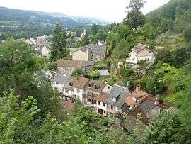
A general view of Vic-sur-Cère | ||
| ||
 Vic-sur-Cère | ||
|
Location within Auvergne-Rhône-Alpes region  Vic-sur-Cère | ||
| Coordinates: 44°58′50″N 2°37′33″E / 44.9806°N 2.6258°ECoordinates: 44°58′50″N 2°37′33″E / 44.9806°N 2.6258°E | ||
| Country | France | |
| Region | Auvergne-Rhône-Alpes | |
| Department | Cantal | |
| Arrondissement | Aurillac | |
| Canton | Vic-sur-Cère | |
| Intercommunality | Cère et Goul en Carladès | |
| Government | ||
| • Mayor (2014–2020) | Mme Dominique Bru | |
| Area1 | 29.37 km2 (11.34 sq mi) | |
| Population (2008)2 | 1,985 | |
| • Density | 68/km2 (180/sq mi) | |
| Time zone | CET (UTC+1) | |
| • Summer (DST) | CEST (UTC+2) | |
| INSEE/Postal code | 15258 / 15800 | |
| Elevation | 652–1,262 m (2,139–4,140 ft) | |
|
1 French Land Register data, which excludes lakes, ponds, glaciers > 1 km² (0.386 sq mi or 247 acres) and river estuaries. 2 Population without double counting: residents of multiple communes (e.g., students and military personnel) only counted once. | ||

Vic-sur-Cère (Occitan: Vic en Carladés) is a commune in the Cantal department in south-central France.
Population
| Historical population | ||
|---|---|---|
| Year | Pop. | ±% |
| 1962 | 1,721 | — |
| 1968 | 1,782 | +3.5% |
| 1975 | 1,963 | +10.2% |
| 1982 | 2,066 | +5.2% |
| 1990 | 1,968 | −4.7% |
| 1999 | 1,890 | −4.0% |
| 2006 | 1,985 | +5.0% |
See also
References
| Wikimedia Commons has media related to Vic-sur-Cère. |
This article is issued from Wikipedia - version of the 7/21/2016. The text is available under the Creative Commons Attribution/Share Alike but additional terms may apply for the media files.