Vermont Route 10
| ||||
|---|---|---|---|---|
|
Map of Windsor County in eastern Vermont with VT 10 highlighted in red | ||||
| Route information | ||||
| Maintained by VTrans | ||||
| Length: | 4.373 mi[1] (7.038 km) | |||
| Major junctions | ||||
| West end: |
| |||
| East end: |
| |||
| Location | ||||
| Counties: | Windsor | |||
| Highway system | ||||
| ||||

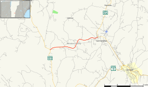
Vermont Route 10 is a state highway located in Windsor County, Vermont, United States. The western terminus of the 4.37-mile (7.03 km) long road is at Vermont Route 103 in Chester and the eastern terminus is at Vermont Route 106 in Springfield.
Route description
VT 10 begins at VT 103 south of the community of Gassetts in the town of Chester. From there the road winds its way eastward into the town of Springfield, where it terminates at VT 106 in North Springfield. The Hartness State Airport is located just northeast of the eastern end of VT 10 on VT 106.
Major intersections
The entire route is in Windsor County. [1]
| Location[1] | mi[1] | km | Destinations | Notes | |
|---|---|---|---|---|---|
| Chester | 0.000 | 0.000 | |||
| Springfield | 4.373 | 7.038 | |||
| 1.000 mi = 1.609 km; 1.000 km = 0.621 mi | |||||
References
- 1 2 3 4 Traffic Research Unit (May 2013). "2012 (Route Log) AADTs for State Highways" (PDF). Policy, Planning and Intermodal Development Division, Vermont Agency of Transportation. Retrieved March 10, 2015.
External links
This article is issued from Wikipedia - version of the 5/21/2015. The text is available under the Creative Commons Attribution/Share Alike but additional terms may apply for the media files.