Vermilion River (Alberta)
| Vermilion River | |
|---|---|
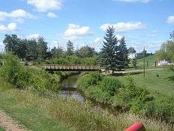 The Vermilion River in Vegreville | |
| Country |
|
| Basin | |
| Main source |
Central Alberta 690 m (2,260 ft) 53°08′17″N 111°55′23″W / 53.13806°N 111.92306°W |
| River mouth |
North Saskatchewan River 510 m (1,670 ft) 53°39′34″N 110°20′08″W / 53.65944°N 110.33556°WCoordinates: 53°39′34″N 110°20′08″W / 53.65944°N 110.33556°W |
| Physical characteristics | |
| Length | 255 km (158 mi) |
| Discharge |
|
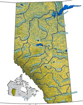
The Vermilion River is a tributary of the North Saskatchewan River in east-central Alberta, Canada. Its lower course flows through the County of Vermilion River, which is named after this river.
Course
The Vermilion River is formed from spring runoff and rainfall south of the town of Vegreville. It flows northeast through Vegreville, then continues in that direction until the town of Two Hills, where it turns southeast. At Vermilion, a reservoir is created by a dam on the river. After that, the river turns again to the northeast. It empties into the North Saskatchewan River 16 km north of Marwayne.
Vermilion River has a length of 255 km. Before its confluence with the North Saskatchewan River, it has an average water level of 16.5 m.[1]
The Vermilion Provincial Park is established on the banks of the river.
See also
References
- 1 2 Alberta River Basins Archived March 11, 2007, at the Wayback Machine. - Vermilion River at Range Road 105