Várpalota
| Várpalota | ||
|---|---|---|
|
Castle | ||
| ||
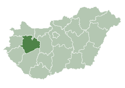
 Várpalota Location of Várpalota | ||
| Coordinates: 47°11′56″N 18°08′15″E / 47.19888°N 18.13761°ECoordinates: 47°11′56″N 18°08′15″E / 47.19888°N 18.13761°E | ||
| Country |
| |
| County | Veszprém | |
| Area | ||
| • Total | 77.26 km2 (29.83 sq mi) | |
| Population (2004) | ||
| • Total | 21,371 | |
| • Density | 243.98/km2 (631.9/sq mi) | |
| Time zone | CET (UTC+1) | |
| • Summer (DST) | CEST (UTC+2) | |
| Postal code | 8100 | |
| Area code(s) | 88 | |

Várpalota is a town in Western Hungary, in the Transdanubian county of Veszprém. It was a mining town during the Socialist era, but the mines have been closed. Most of the citizens work in the nearby cities, Veszprém or Székesfehérvár.
History
The town's origins are linked to the Roman and Avar periods, as testified verified by burial mounds, tombstones and Roman artifacts in the outskirts of the town, some of which can be found in the lapidary of Thuri Castle.
In the Middle Ages it was a flourishing market town. In the 20th century it became a center for coal mining.
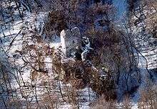
Bátorkő in winter.
Main sights
- The Thuri castle, located in the heart of the town. It was commanded, among the others, by György Thuri. It is currently home to the Museum of Chemistry, and the collection of the memories of coal mining. Concerts and theatre performances are held there every summer.
- The old Catholic church, home to Romanesque and early-Gothic frescos in a particularly good condition. One of the World War I memorials erected in those days and destroyed in the tempests of the history can be found here.
- Jó Szerencsét (Good Luck) Community Centre, which houses four large-sized Gobelin works of Noémi Ferenczy. The one-man exhibition of Frigyes Matzon, one of the significant representatives of constructivism can be visited in the nearby Nagy Gyula Gallery, which was converted from a synagogue.
- Baroque Reformed church with its irregularly arched western façade. It was built on the walls of the formerly Hussar Castle. It houses the memorial plaque of Mária Molnár.
- Zichy Castle. The library-room with its wooden cover and its frescos recalling mythological ages, is a regular place of cultural events. Italso includes the Zichy-Chapel and the altar carved from sandstone in the Catholic cemetery. Among the graves are the memorial of militiaman martyrs of the Hungarian Revolution and War of Independence belonging to the earl's family.
- Memorials of the Hungarian Revolution and War of Independence in 1848-49, of the World War heroes and victims, of the heroes of Revolution in 1956.
Twin towns
 Petroşani, Romania
 Fermo, Italy
 Kremnica, Slovakia
 Wolfsberg, Austria
 Polhov Gradec, Slovenia
External links
This article is issued from Wikipedia - version of the 5/3/2015. The text is available under the Creative Commons Attribution/Share Alike but additional terms may apply for the media files.