Utah State Route 154
| ||||
|---|---|---|---|---|
| Bangerter Highway | ||||
 | ||||
| Route information | ||||
| Defined by Utah Code §72-4-121 | ||||
| Maintained by UDOT | ||||
| Length: | 24.319 mi[1] (39.138 km) | |||
| Existed: | 1989 – present | |||
| Major junctions | ||||
| South end: |
| |||
|
| ||||
| North end: |
| |||
| Highway system | ||||
| ||||

State Route 154 (SR-154) or Bangerter Highway (named after former Utah Governor Norman H. Bangerter) is a partial expressway running west and then north from Draper through western Salt Lake County, eventually reaching the Salt Lake City International Airport in Salt Lake City. Construction began in 1988 after planning for the highway began more than two decades prior. For the next ten years, portions of the highway opened as constructed, with the entire route finished by 1998.
Original plans for the six-lane expressway running through the western suburbs of Salt Lake City placed Bangerter Highway running further north past the Salt Lake City International Airport into Davis County. However, any route north of the airport never reached fruition, whereas the original southerly end of the route was extended from Redwood Road to I-15.
Route description
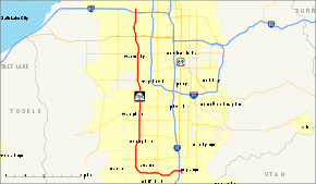
State Route 154 (Bangerter Highway) begins just southeast of a single-point urban interchange at I-15 at the intersection of 13800 South in the Salt Lake City suburb of Draper. The three-lane road curves from the north to the west and widens to four lanes before accessing the I-15 interchange. Past the freeway exit, SR-154 expands to three lanes in each direction with a median barrier in the center. With the exception of two variations in the course of the road prior to an intersection at Redwood Road (SR-68), the highway heads relatively due west (there is a dip to the south for about a mile as the roadway crosses the Jordan River). Throughout its whole route, with four exceptions (I-15, SR-68, SR-48, SR-201, and I-80), SR-154 intersects only major cross streets at grade-level intersections. The route runs into the boundary of Bluffdale and Riverton before definitively entering Riverton boundaries when the highway makes a northerly curve.

Making a slight easterly jog in the process, the road maintains its six-lane divided-highway setup as it intersects 13400 South, 12600 South (SR-71) and 11400 South (SR-175 and the access road to Daybreak and the Oquirrh Mountain LDS Temple). Arriving in South Jordan, more cross streets intersect Bangerter Highway (South Jordan Parkway SR-151, 9800 South and 9000 South) before the route traverses into West Jordan. There is no at-grade intersection at 7800 South SR-48, but an overpass with on- and off- ramps, permitting easy access to South Valley Regional Airport and allowing uninterrupted traffic flow on Bangerter. SR-154 continues, intersecting 7000 South (access to Jordan Landing) and Bennion Boulevard (6200 South). The route slides to the west, entering Taylorsville and crossing 5400 South (SR-173) and 4700 South.
As SR-154 enters West Valley City, it intersects 4100 South, 3500 South (SR-171), and 3100 South. The highway curves northwest, intersecting with Parkway Boulevard (2700 South), Lake Park Boulevard (2400 South), and 2100 South before meeting SR-201 (21st South Freeway) at a diverging diamond interchange and entering Salt Lake City. Losing one lane in each direction, the route meanders northerly toward the Airport, crossing 1820 South and California Avenue (1300 South) before meeting at a cloverleaf interchange at I-80 and terminating at the access road to the Airport.[2]
History
Planning for the West Valley Highway began in the 1960s[3] as a local federal-aid project. The proposed alignment began at the curve in SR-68 near 15300 South and proceeded north-northwesterly and northerly, following a path much like the present alignment to I-80. It continued north along what was then the west boundary of the then Salt Lake City Municipal Airport No. 1 (now Salt Lake City International Airport) into 4000 West, curving east onto 2200 North and ending at I-215. A drainage canal was moved to make room for a loop from 2200 North onto northbound I-215,[4] but when the Interstate was finished south of 2200 North (where it had ended for many years) in the mid-1980s,[5] a diamond interchange was built instead.[6] Later the north segment was rerouted to continue north-northeasterly from the airport into Davis County;[7] parts of this are now the Legacy Parkway. Salt Lake County was able to build the highway between SR-201 (2100 South) and I-80 with federal funding, but it took the state to finish it.[3]
In 1989, the Utah Transportation Commission added a portion of the proposed West Valley Highway to the state highway system as State Route 154. A newly proposed corridor ran west from I-15 near 13400 South to near 3200 West, where it joined the older proposal and headed north to I-80.[8] With the help of Governor Norman H. Bangerter, longtime resident of West Valley City, the project received needed money from the state's general fund, and was opened between SR-201 (2100 South) and SR-171 (3500 South) on November 26, 1991.[3] The Transportation Commission renamed the highway after Bangerter in May 1993.[8] It was finally completed to I-15 on 17 November 1998.[9]
In 2007, a continuous flow intersection was constructed at the junction of SR-154 and SR-171 (3500 South), one of a very few such intersections in the United States. The intersection is one of the busiest in the state and handles 100,000 vehicles on a typical weekday.[10] Over the next five years six more intersections were modified to become continuous flow intersections. In 2012 the first interchange (a single-point urban interchange) was completed at a non-freeway junction at 7800 South (SR-48).
Major intersections
The entire route is in Salt Lake County.
| Location | mi[11] | km | Destinations | Notes | |
|---|---|---|---|---|---|
| Draper | 0.000 | 0.000 | 13800 South, Bangerter Parkway | ||
| 0.209 | 0.336 | 150 East | |||
| 0.467 | 0.752 | Single-point urban interchange | |||
| 0.798 | 1.284 | 200 West | |||
| Riverton–Bluffdale line | 3.242 | 5.217 | Single-point urban interchange | ||
| 4.244 | 6.830 | 2700 West | |||
| Riverton | 5.751 | 9.255 | 13400 South | Continuous-flow intersection | |
| 6.759 | 10.878 | ||||
| South Jordan | 8.274 | 13.316 | |||
| 9.600 | 15.450 | 10400 South | |||
| 10.384 | 16.711 | 9800 South | |||
| West Jordan | 11.390 | 18.330 | 9000 South | ||
| 12.884 | 20.735 | Single-point urban interchange | |||
| 13.885 | 22.346 | 7000 South | Continuous-flow intersection | ||
| Taylorsville | 14.893 | 23.968 | 6200 South | Continuous-flow intersection | |
| 15.930 | 25.637 | Continuous-flow intersection | |||
| Taylorsville–West Valley City line | 16.939 | 27.261 | 4700 South | Continuous-flow intersection | |
| West Valley City | 17.936 | 28.865 | 4100 South | Continuous-flow intersection | |
| 18.946 | 30.491 | Continuous-flow intersection | |||
| 19.455 | 31.310 | 3100 South | Continuous-flow intersection | ||
| 19.991 | 32.172 | Parkway Boulevard | |||
| 20.513 | 33.012 | 2400 South | |||
| 20.839 | 33.537 | Frontage Road | |||
| West Valley City–Salt Lake City line | 21.013 | 33.817 | Diverging diamond interchange | ||
| Salt Lake City | 21.388 | 34.421 | 1820 South | ||
| 22.267 | 35.835 | California Avenue | |||
| 23.708 | 38.154 | Cloverleaf interchange with directional ramp; former SR-186 | |||
| 24.319 | 39.138 | Salt Lake City International Airport | Continuation beyond I-80 | ||
| 1.000 mi = 1.609 km; 1.000 km = 0.621 mi | |||||
References
| Wikimedia Commons has media related to Utah State Route 154. |
- ↑ "State Route 154 Highway reference". Utah Department of Transportation.
- ↑ "Google Maps; overview of SR-154". Google.
- 1 2 3 Deseret News, W.V. Highway Now a Reality After Traveling a Rocky Road, November 27, 1991
- ↑ Utah Department of Transportation, Highway Resolutions: "Route 215". (9.62 MB), updated November 2007, accessed May 2008, pp. 9, 11, 14
- ↑ Federal Highway Administration, National Bridge Inventory database, 2006
- ↑ Google (June 8, 2009). "Google Maps 2100 North interchange" (Map). Google Maps. Google. Retrieved June 8, 2009.
- ↑ Utah Department of Transportation, Highway Resolutions: "Route 172". (838 KB), updated November 2007, accessed May 2008, p. 5
- 1 2 Utah Department of Transportation, Highway Resolutions: "Route 154". (2.18 MB), updated November 2007, accessed May 2008, p. 14
- ↑ John Keahey, Salt Lake Tribune, Bangerter's Last Section Opens Today; Multilane highway extends from S.L. airport to Draper, November 17, 1998, p. B1
- ↑ "Continuous Flow Intersection to be Built on Bangerter Hwy". KSL-TV. Retrieved April 13, 2008.
- ↑ Utah Department of Transportation, Highway Reference Information: "SR-154". (20.7 KB), updated May 2008, accessed July 2008