Utah State Route 103
| ||||
|---|---|---|---|---|
| 650 North | ||||
|
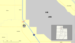
SR-103 highlighted in red | ||||
| Route information | ||||
| Defined by Utah Code §72-4-116 | ||||
| Maintained by UDOT | ||||
| Length: | 0.225 mi[1] (0.362 km) | |||
| Existed: | April 19, 1965[2] – present | |||
| Major junctions | ||||
| West end: |
| |||
|
| ||||
| East end: | Falcon Hill National Aerospace Research Park entrance | |||
| Highway system | ||||
| ||||

State Route 103 (SR-103) is a 0.225-mile-long (362 m) urban minor arterial state highway in the U.S. state of Utah. It branches off from SR-126 (Main Street) in downtown Clearfield and extends east to Interstate 15 (I-15), terminating at the entrance to the Falcon Hill National Aerospace Research Park, just outside Hill Air Force Base. The entire route is located in Davis County and was formed in 1965 coinciding with the construction of I-15. The route has been mostly unchanged since its formation, except for the moniker of the highway and the route number of its western terminus.
The western terminus, in a stretch of fourteen years from its inception, has gone from SR-1 in 1965, to SR-106 in 1967, to SR-84 in 1969, and SR-126 in 1979. In 1979, the moniker of the roadway for SR-103 was changed from 600 North to 650 North. SR-103 is one of four Utah state highways that connect to Hill Air Force Base, the others being SR-97, SR-168, and SR-232. Only SR-168 has a lower average daily traffic count, with roughly 1,000 vehicles-per-day traveling along the highway compared to SR-103's approximately 16,000 vehicles-per-day. The only major change to the highway since its formation was the addition of traffic lights at the on and off ramps for I-15.
Route description
State Route 103 (SR-103) begins at an intersection with SR-126, locally known as Main Street in Clearfield. At this intersection, 650 North, which continues the right-of-way, lengthens from a two lane local street into a four lane arterial boulevard at SR-126. SR-103 begins its progression eastward, passing between two commercial complexes. After a crossing of the Davis Weber Canal, the sidewalk on the southern side of the roadway turns to the south to follow the canal forming the Clearfield Canal Trail.[3] SR-103 highway turns to the northeast, intersecting with the southbound on-ramp and off-ramp to Interstate 15 (I-15). After this intersection, SR-103 expands to five lanes, and crosses under the southbound and northbound lanes of I-15.[4] After the overpasses, SR-103 intersects with the northbound on-ramp and off-ramp from I-15. The highway progresses straight for about 300 ft (91 m), passing a gated fence on the north side of the highway leading to a rail stub, and the dead-end of Aspen Avenue, before reaching the entrance to the Falcon Hill National Aerospace Research Park, just outside Hill Air Force Base, the designated eastern terminus of SR-103. From there, the right-of-way continues on the arterial in the base itself.[4]
SR-103 serves the function of connecting the town of Clearfield, and residents along I-15 to Hill Air Force Base. The base, as of 2012, was the sixth largest employer in the state of Utah and is the third largest employer which is neither the state government nor a state-funded higher education institution.[5] SR-103 is one of four Utah state highways that connect to Hill Air Force Base, the others being SR-97,[6] SR-168[7] and SR-232,[8] Only SR-168 has a lower average daily traffic count, with roughly 1,000 vehicles-per-day traveling along the highway compared to SR-103's approximately 16,000 vehicles-per-day.[9] This is a decline from previous years (in 2007 the average on SR-103 was 22,525; in 2006, the average was 22,215; in 2005, 21,275). Four percent of this traffic was composed of trucks.[10] The measurement point for the traffic counts is at the eastern terminus of SR-103, the entrance to the Falcon Hill National Aerospace Research Park. The highway is codified as Utah Code §72-4-116, and is designated as a minor arterial,[11] which the Federal Highway Administration defines as linking major arterials at a lower volume than a primary arterial.[12]
History
SR-103 was originally on an alignment of Harrison Street in the city of Ogden. Between 1964 and 1965, the state of Utah and the Utah Department of Transportation (UDOT) decommissioned the alignment of SR-103 on Harrison Street, renumbering the portion of Harrison Street as SR-203. The SR-103 designation was soon rewritten in the Utah Code as an access road to Hill Air Force Base on April 19, 1965.[2]

The new alignment, which the state felt was a major connector to a federal military institution, Hill Air Force Base, from U.S. Route 91 (US-91) and I-15 was chosen as a state highway[2] US-91, before the formation of I-15, was the major thoroughfare through Utah, connecting it to California and Montana.[13] SR-103 was then designated onto its alignment, adding 0.225-mile (362 m) to the Utah state route system.[2] Prior to designation, the alignment of 600 North went from U.S. Route 91 and uninterrupted until the Hill Air Force Base. In 1964, a year prior to designation, a 27-foot-long (8.2 m) concrete culvert bridge was constructed over the Davis Weber Canal.[14] The two bridges for I-15's southbound and northbound roadways were built in 1966 and are two 159-foot-long (48.5 m) concrete continuous tee beam overpasses.[15][16]
The route has been mostly unchanged since its formation, except for the moniker of the highway and the western terminus, of which SR-103 progresses. The western terminus, in a stretch of fourteen years from its inception, went from SR-1 in 1965, to SR-106 in 1967 to SR-84 in 1969 and SR-126 in 1979. In 1979, the moniker of the roadway for SR-103 was changed from 600 North to 650 North. In 1998, the legal definition of SR-103 was changed in the state codes.[2]
The alignment of SR-103, outside of the roadway renumbering, have received some technical changes as well. In November 1992, UDOT confirmed that the interchange of I-15 and SR-103 (exit 335) was to be given traffic lights to help monitor traffic. The mayor at the time, Neldon Hamblin, approved of the project, and put the project up for bids for construction. The interchange was holding up motorists needing to turn left up to 20 minutes.[17]
Major intersections
The entire route is in Clearfield, Davis County. [18]
| mi[1] | km | Destinations | Notes | ||
|---|---|---|---|---|---|
| 0.000 | 0.000 | Western terminus, roadway continues west as 650 north | |||
| 0.080– 0.174 | 0.129– 0.280 | Exit 335 | |||
| 0.225 | 0.362 | Falcon Hill National Aerospace Research Park entrance | Eastern terminus, roadway east towards the Hill AFB access gate | ||
| 1.000 mi = 1.609 km; 1.000 km = 0.621 mi | |||||
See also
 U.S. Roads portal
 Utah portal
- List of Utah State Routes shorter than one mile
References
- 1 2 "Route 103" (PDF). Highway Reference. Utah Department of Transportation. August 13, 2013. Retrieved December 18, 2013. External link in
|work=(help) - 1 2 3 4 5 "Route 103" (PDF). Highway Resolutions. Utah Department of Transportation. November 2008. Retrieved December 17, 2013. External link in
|work=(help) - ↑ Roberts, Shayln (June 4, 2008). "Clearfield Canal Trail to open Saturday". The Davis Clipper. Bountiful, Utah. OCLC 11930754. Retrieved December 18, 2013.
- 1 2 Google (December 17, 2013). "Overview map of UT 103" (Map). Google Maps. Google. Retrieved December 17, 2013.
- ↑ Utah's Largest Employers — Annual Average Employment (PDF) (Report). Utah Department of Workforce Services. 2012.
- ↑ "Route 97" (PDF). Highway Reference. Utah Department of Transportation. December 12, 2013. Retrieved December 18, 2013.
- ↑ "Route 168" (PDF). Highway Reference. Utah Department of Transportation. May 1, 2008. Retrieved December 19, 2013.
- ↑ "Route 232" (PDF). Highway Reference. Utah Department of Transportation. May 1, 2008. Retrieved December 18, 2013.
- ↑ "Traffic on Utah Highways" (PDF). Utah Department of Transportation. 2012. p. 21. Retrieved December 17, 2013.
- ↑ "Truck Traffic on Utah Highways" (PDF). Utah Department of Transportation. 2012. p. 20. Retrieved December 17, 2013.
- ↑ Ogden — Layton Urbanized Area Functional Class System (Map). 1 in ≈ 1.2 mi (2.54 cm ≈ 1.93 km). Utah Department of Transportation. March 29, 2012. Retrieved December 17, 2013.
- ↑ Highway Functional Classification Concepts, Criteria and Procedures (PDF). Federal Highway Administration. 2013. pp. 15–16. Retrieved December 17, 2013.
- ↑ United States System of Highways Adopted for Uniform Marking by the American Association of State Highway Officials (Map). 1:7,000,000. Cartography by U.S. Geological Survey. Bureau of Public Roads. November 11, 1926. OCLC 32889555. Retrieved December 18, 2013.
- ↑ Federal Highway Administration (2012). "NBI Structure Number: 0E1346". National Bridge Inventory. Federal Highway Administration.
- ↑ Federal Highway Administration (2012). "NBI Structure Number: 3D 719". National Bridge Inventory. Federal Highway Administration.
- ↑ Federal Highway Administration (2012). "NBI Structure Number: 1D 719". National Bridge Inventory. Federal Highway Administration.
- ↑ Staff (November 12, 1992). "Clearfield To Get Signals for I-15 Junction". Deseret News. p. 1. OCLC 10171976.
- ↑ Davis County (Map). .25 in ≈ 1 mi (.64 cm ≈ 1.93 km). General Highway Map. Utah Department of Transportation. 2005. Retrieved December 18, 2013.
External links