Upper Strasburg, Pennsylvania
| Upper Strasburg, Pennsylvania | |
|---|---|
| Unincorporated community | |
|
Methodist church | |
 Upper Strasburg  Upper Strasburg | |
| Coordinates: 40°3′37″N 77°42′32″W / 40.06028°N 77.70889°WCoordinates: 40°3′37″N 77°42′32″W / 40.06028°N 77.70889°W | |
| Country | United States |
| State | Pennsylvania |
| County | Franklin |
| Township | Letterkenny |
| Elevation | 728 ft (222 m) |
| Time zone | Eastern (EST) (UTC-5) |
| • Summer (DST) | EDT (UTC-4) |
| ZIP code | 17265 |
| Area code(s) | 717 |
| GNIS feature ID | 1190256[1] |

Upper Strasburg is an unincorporated community in Letterkenny Township in Franklin County, Pennsylvania, United States.
Upper Strasburg is located at the intersection of Pennsylvania Route 533, State Route 4004 (Mountain Road/Valley Road), and Community Road northwest of Chambersburg and north of the Letterkenny Army Depot.[2]
The road from Upper Strasburg to Fannettsburg and on to Burnt Cabins was built about 1790 and for many years formed part of the main road from Philadelphia to Pittsburgh. The road is now part of SR 4004 and was known as Three Mountain Road or Horse Valley Road but is generally known as Upper Strasburg Road now.[3]
The town was laid out in 1789 by Dewalt Keefer and serviced Conestoga wagons and travelers crossing the mountains. It was originally known simply as Strasburg, but its early post office was known as Upper Strasburg to distinguish it from towns in eastern Pennsylvania. The post office was established before 1830.[4] In 1873 the town had three churches, "one hotel, one steam tannery, one sawmill, two stores, two blacksmith, two shoe-maker, two cabinet-maker, one tailor and one saddler shops, and two hundred ninety-three inhabitants."[5]
ZIP code information
The Upper Strasburg ZIP code 17265 covers 37.93 sq mi (98.2 km2), a population of 496 and 294 housing units, 211 of them occupied.[6][7]
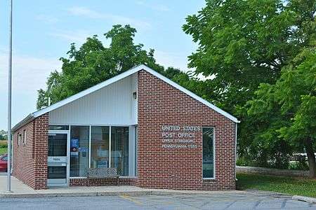 Post office
 End of PA 533
References
| Wikimedia Commons has media related to Upper Strasburg, Pennsylvania. |
- ↑ "Upper Strasburg". Geographic Names Information System. United States Geological Survey.
- ↑ Franklin County, Pennsylvania Highway Map (PDF) (Map). PennDOT. 2015. Retrieved January 2, 2016.
- ↑ "National Historic Landmarks & National Register of Historic Places in Pennsylvania" (Searchable database). CRGIS: Cultural Resources Geographic Information System. Note: This includes Jo G. Treat (September 2004). "National Register of Historic Places Inventory Nomination Form: Skinner Tavern" (PDF). Retrieved 2012-02-04.
- ↑ Green, Duff (1831). Table of the Post Offices in the United States. United States. Post Office Dept. p. 94.
- ↑ M'Cauley, I.H. (1878). Historical Sketch of Franklin County, Pennsylvania. p. 152. Retrieved August 3, 2016.
- ↑ "American Fact Finder, 17265". U.S. Census Bureau. Retrieved August 3, 2016.
- ↑ "17246". United States Zip Codes. Retrieved August 3, 2016. Note that this is not an official USPS website, but it includes a map.
Municipalities and communities of Franklin County, Pennsylvania, United States | ||
|---|---|---|
| Boroughs | 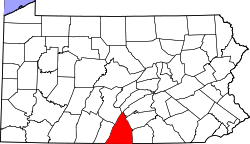 | |
| Townships | ||
| CDPs | ||
| Unincorporated communities | ||
| Footnotes | ‡This populated place also has portions in an adjacent county or counties | |