University Park, Aarhus
| University Park | |
|---|---|
 | |
| Type | Urban park |
| Location | Aarhus, Denmark |
| Area | 15 hectares |
| Created | 1933 |
| Owned by | Aarhus University |
Aarhus University Park or the University Park (Danish: Universitetsparken) is a public park in central Aarhus, Denmark.[1] The park is situated in the neighbourhood of Vesterbro in Midtbyen close to Trøjborg, and is bounded by the streets of Nørrebrogade, Nordre Ringgade, Langelandsgade, Kaserneboulevarden and Høegh Guldbergs Gade.[2] The park forms part of the Aarhus University campus and figures in the Danish Culture Canon. The park and campus has received international recognition for its aesthetic values and it has been protected by law since 1993, in order to conserve its unique design.[3][4]
The University Park was established in 1933 in conjunction with the university. The campus master plan competition was won in 1931 by the collaborative scheme of Danish architects Kay Fisker, C. F. Møller and Povl Stegmann in collaboration with landscape architect Carl Theodor Sørensen who designed the park.[5]
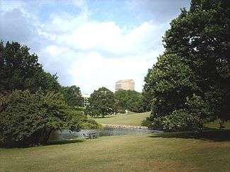
The park is encircled by the university buildings, the Natural History Museum and dormitories. It is constructed across an undulating landscape in an old moraine valley stretching from Katrinebjerg in Vejlby, in the north, to the Bay of Aarhus in the east. The park is characterized by its oak trees, two artificial lakes and large open, grassy areas. From under the amphitheatre a stream run north to south through the park in the valley before it feeds into the lakes, home to water fowl and amphibians. The adjoining Vennelystparken to the south contrasts the University Park with different terrain and fauna and mixed tree growth.
In 1949 an amphitheatre was added south of the main building of the university which has become a central element in recreational activities in the park.[6] Annually a boat race is held in the lakes between the faculties of the university, which has become a public event.[7]
.jpg)


References
- ↑ "The University Park" (in Danish). Aarhus Municipality through VisitAarhus. Retrieved 3 August 2015.
- ↑ "Friluftsliv" (in Danish). Aarhus Municipality. Retrieved 2 August 2015.
- ↑ Stadsarkitektens kontor (February 1993). "Lokalplan nr. 376" (PDF). Århus Kommune. Retrieved 29 June 2015.
|section=ignored (help) - ↑ "Lokalplan 376" (PDF) (in Danish). Aarhus Municipality. Retrieved 3 August 2015.
- ↑ "Universitetsparken". Aarhus State Archiveslanguage=Danish. Retrieved 3 August 2015.
- ↑ "C. Th. Sørensen Landskabsarkitekt" (in Danish). Aarhus University. Retrieved 3 August 2015.
- ↑ "Stemning Sol og Sejlads" (in Danish). Denkorteavis. Retrieved 3 August 2015.
External links
Coordinates: 56°10′05″N 10°12′11″E / 56.168°N 10.203°E