City seal of Aarhus
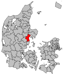
Aarhus Municipality (Danish: Aarhus Kommune), until 2011 formerly known as Århus Municipality (Danish: Århus Kommune), is a municipality in the Central Region, on the east coast of the Jutland peninsula in central Denmark.
The municipality covers an area of 470.95 km2 (181.83 sq mi) (www.noegletal.dk), and has a population of 331,332 (April 1, 2016) ("statistikbanken.dk befolkning og valg"). The main town and the site of its municipal council is the city of Aarhus.[1] Neighbouring municipalities are Syddjurs to the north, Favrskov to the northwest, Skanderborg to the southwest, and Odder to the south. It forms part of the East Jutland metropolitan area.
Aarhus Municipality was not merged with other municipalities in the nationwide Kommunalreformen ("The Municipal Reform" of 2007) due to its already relatively large size and population.
Politics
Aarhus City Council (Aarhus Byråd) is also the municipal government. The city council consists of 31 members elected for four-year terms. Administratively the municipality is divided into six minor agencies which together constitute the magistrate led by a mayor and five aldermen as administrative directors. It is the only Danish city with a magistrate structure.[2] The six departments of the city are the Mayor's Department, Social Affairs and Employment, Technical Services and Environment, Health and Care, Culture and Citizens Services and Children and Young People which handle all the day-to-day operations of the city.[3]
The current Mayor of Aarhus municipality is Jacob Bundsgaard of the Social Democrats,[4] who took over after Nicolai Wammen in August 2011.[5] Wammen wanted to focus on the upcoming election for Parliament.
Politically Aarhus leans left and the largest political party has historically been the Social Democratic Party which has also held the mayor's office for all terms with the notable exception of the 2001–2005 term when Louise Gade of Venstre became both the first female and non-Social Democratic mayor. The gender composition of the city council has risen steadily in favour of women through the 20th century and currently 9 of 31 members are women.[6]
The first publicly elected mayor of Aarhus was appointed in 1919. In the 1970 Danish Municipal Reform the current Aarhus municipality was created by merging 20 municipalities.[7] Aarhus was the seat of Aarhus County until the 2007 Danish municipal reform, which substituted the Danish counties with five regions and replaced Aarhus County with Central Denmark Region (Region Midtjylland), seated in Viborg.[8]
Political party composition of Aarhus Municipal Council
| Year |
A |
B |
C |
F |
I |
O |
V |
Y |
Z |
Ø |
Other |
% |
♀ |
♂ |
Mandate distribution |
| 1970 |
17 | 2 | 8 | 1 | | | 3 | | | | | 70.3 | 4 | 27
|
|
|
| 1974 |
13 | 2 | 4 | 2 | | | 4 | 1 | 2 | | 3 | 58.1 | 6 | 25
|
|
|
| 1978 |
13 | 2 | 5 | 3 | | | 3 | 1 | 2 | | 2 | 68.7 | 8 | 23
|
|
|
| 1981 |
11 | 1 | 6 | 5 | | | 3 | 2 | 1 | | 2 | 68.6 | 11 | 20
|
|
|
| 1985 |
12 | 1 | 7 | 7 | | | 2 | 1 | | | 1 | 65.6 | 12 | 19
|
|
|
| 1989 |
12 | 1 | 5 | 6 | | | 3 | | 1 | 2 | 1 | 63.1 | 11 | 20
|
|
|
| 1993 |
15 | 1 | 3 | 4 | | | 6 | | 1 | 1 | | 68.4 | 12 | 19
|
|
|
| 1997 |
13 | 1 | 3 | 4 | | 2 | 7 | | | 1 | | 70.5 | 13 | 18
|
|
|
| 2001 |
11 | 2 | 2 | 3 | | 1 | 11 | | | 1 | | 85.13 | 6 | 25
|
|
|
| 2005 |
13 | 2 | 1 | 2 | | 1 | 11 | | | 1 | | 71.80 | 8 | 23
|
|
|
| 2009 |
14 | 1 | 3 | 5 | | 2 | 5 | | | 1 | | 63.70 | 13 | 18
|
|
|
| 2013 |
13 | 2 | 2 | 2 | 1 | 2 | 6 | | | 3 | | 70.49 | 9 | 22
|
|
|
| Data from Statistics Denmark,[9] KMD,[10] ODAA.dk,[11] Aarhus Municipality[12] |
Districts and subdivisions
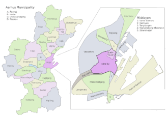
Aarhus Municipality has 45 electoral wards and polling stations in four electoral districts for the folketing.[13] The diocese of Aarhus has four deaneries composed of 60 parishes within Aarhus municipality.[14] Aarhus municipality contains 21 postal districts and some parts of another 9.[15] The urban area of Aarhus and the immediate suburbs are divided into the districts Aarhus C, Aarhus N, Aarhus V, Viby J, Højbjerg and Brabrand.
Aarhus is segmented into districts on different levels often containing several distinct neighbourhoods within them. The historical centre, known as Indre By (lit. English, "Inner City"), includes the neighbourhoods Centralværkstedet, the Latin Quarter and the areas around the Central Station and Aarhus Concert Hall.[16] The inner city beltway Ring 1 contains the larger district Midtbyen (lit. Town Centre), roughly equivalent to postal district Aarhus C, and is composed of the neighbourhoods Indre By, Vesterbro, Frederiksbjerg, Aarhus Ø, Marselisborg and Nørre Stenbro.[17]
North of the inner beltway lies the district Aarhus N, containing the neighbourhoods Trøjborg, Risskov, Vejlby, Skejby, Christiansbjerg and Vorrevangen and to the west lies Langenæs, Åbyhøj and Aarhus V, comprising the neighbourhoods Hasle, Frydenlund, Herredsvang and Møllevangen, while the district of Højbjerg lies to the south. Districts and suburbs further out are Brabrand, Egå, Gellerup, Hasselager, Holme, Kolt, Rosenhøj, Skæring, Skåde, Slet, Stavtrup, Tilst and Tranbjerg.
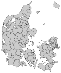
Cities and towns
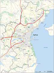
Municipal map
Statistcs Denmark defines towns or cities as areas with more than 200 residents in a continuous settlement with no more than 200 meters between residential structures. In 2015 there were 19 such areas in Aarhus Municipality, the largest being the city of Aarhus with some 260,000 inhabitants, while some 50,000 people lived in urban areas elsewhere in the municipality. The city of Aarhus is the second largest urban area in Denmark, the principal port on the east coast of Jutland, and the seat of Denmark's second-largest bishopric. In 2013 Beder and Malling was officially counted as a single urban area for the first time.[18] Towns in the municipality are generally considered satellites of Aarhus.
Population figures from Statistics Denmark, 1. January, 2015.[18]
References
Notes
External links
Coordinates: 56°10′00″N 10°15′00″E / 56.1667°N 10.25°E / 56.1667; 10.25