Uniopolis, Ohio
| Uniopolis, Ohio | |
|---|---|
| Unincorporated community | |
|
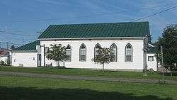
Side of the village hall | |
 Location of Uniopolis, Ohio | |
 Location of Uniopolis in Auglaize County | |
| Coordinates: 40°36′7″N 84°5′12″W / 40.60194°N 84.08667°WCoordinates: 40°36′7″N 84°5′12″W / 40.60194°N 84.08667°W | |
| Country | United States |
| State | Ohio |
| County | Auglaize |
| Township | Union |
| Government | |
| Area[1] | |
| • Total | 0.16 sq mi (0.41 km2) |
| • Land | 0.16 sq mi (0.41 km2) |
| • Water | 0 sq mi (0 km2) |
| Elevation[2] | 938 ft (286 m) |
| Population (2010)[3] | |
| • Total | 222 |
| • Estimate (2012[4]) | 221 |
| • Density | 1,387.5/sq mi (535.7/km2) |
| Time zone | Eastern (EST) (UTC-5) |
| • Summer (DST) | EDT (UTC-4) |
| ZIP code | 45888 |
| Area code(s) | 419 |
| FIPS code | 39-78848[5] |
| GNIS feature ID | 1047346[2] |
Uniopolis is an unincorporated community and former village in Auglaize County, Ohio, United States. The population was 222 at the 2010 census. It is included in the Wapakoneta, Ohio Micropolitan Statistical Area. In 2013, voters chose to disincorporate Uniopolis.[6]
The village is served by the Wapakoneta City School District.
History
Uniopolis was founded in 1837.[7] Its village hall, now a museum,[8] is listed on the National Register of Historic Places.[9]
Geography
Uniopolis is located at 40°36′7″N 84°5′12″W / 40.60194°N 84.08667°W (40.601985, -84.086537).[10]
According to the United States Census Bureau, the village had a total area of 0.16 square miles (0.41 km2), all land.[1]
Demographics
| Historical population | |||
|---|---|---|---|
| Census | Pop. | %± | |
| 1880 | 116 | — | |
| 1910 | 245 | — | |
| 1920 | 193 | −21.2% | |
| 1930 | 197 | 2.1% | |
| 1940 | 220 | 11.7% | |
| 1950 | 271 | 23.2% | |
| 1960 | 298 | 10.0% | |
| 1970 | 291 | −2.3% | |
| 1980 | 259 | −11.0% | |
| 1990 | 261 | 0.8% | |
| 2000 | 256 | −1.9% | |
| 2010 | 222 | −13.3% | |
| Est. 2015 | 221 | [11] | −0.5% |
2010 census
As of the census[3] of 2010, there were 222 people, 83 households, and 64 families residing in the village. The population density was 1,387.5 inhabitants per square mile (535.7/km2). There were 96 housing units at an average density of 600.0 per square mile (231.7/km2). The racial makeup of the village was 100.0% White.
There were 83 households of which 27.7% had children under the age of 18 living with them, 65.1% were married couples living together, 7.2% had a female householder with no husband present, 4.8% had a male householder with no wife present, and 22.9% were non-families. 16.9% of all households were made up of individuals and 3.6% had someone living alone who was 65 years of age or older. The average household size was 2.67 and the average family size was 2.97.
The median age in the village was 41.5 years. 18.9% of residents were under the age of 18; 11.4% were between the ages of 18 and 24; 24% were from 25 to 44; 28.5% were from 45 to 64; and 17.6% were 65 years of age or older. The gender makeup of the village was 52.3% male and 47.7% female.
2000 census
As of the census[5] of 2000, there were 256 people, 88 households, and 77 families residing in the village. The population density was 1,640.3 people per square mile (617.8/km²). There were 93 housing units at an average density of 595.9 per square mile (224.4/km²). The racial makeup of the village was 98.83% White, 0.39% African American, 0.39% Native American, and 0.39% from two or more races. Hispanic or Latino of any race were 1.17% of the population.
There were 88 households out of which 44.3% had children under the age of 18 living with them, 71.6% were married couples living together, 10.2% had a female householder with no husband present, and 12.5% were non-families. 10.2% of all households were made up of individuals and 3.4% had someone living alone who was 65 years of age or older. The average household size was 2.91 and the average family size was 3.08.
In the village the population was spread out with 30.1% under the age of 18, 8.2% from 18 to 24, 31.6% from 25 to 44, 18.8% from 45 to 64, and 11.3% who were 65 years of age or older. The median age was 33 years. For every 100 females there were 113.3 males. For every 100 females age 18 and over, there were 113.1 males.
The median income for a household in the village was $37,083, and the median income for a family was $38,750. Males had a median income of $30,909 versus $24,375 for females. The per capita income for the village was $16,099. None of the population or families were below the poverty line.
References
- 1 2 "US Gazetteer files 2010". United States Census Bureau. Archived from the original on January 24, 2012. Retrieved 2013-01-06.
- 1 2 "US Board on Geographic Names". United States Geological Survey. 2007-10-25. Retrieved 2008-01-31.
- 1 2 "American FactFinder". United States Census Bureau. Retrieved 2013-01-06.
- ↑ "Population Estimates". United States Census Bureau. Archived from the original on June 17, 2013. Retrieved 2013-06-17.
- 1 2 "American FactFinder". United States Census Bureau. Archived from the original on September 11, 2013. Retrieved 2008-01-31.
- ↑ Fugleberg, Jeremy (February 25, 2016). "Hit by floods and budget cuts, village to vote on disappearing". The Cincinnati Enquirer. Retrieved 26 February 2016.
- ↑ Auglaize County, Ohio Atlas and History Archived June 11, 2011, at the Wayback Machine., Piqua: Magee Brother Publishing, 1917. Accessed 2007-12-30. 117.
- ↑ What to See, Auglaize County Historical Society, 2010. Accessed 2010-06-07.
- ↑ National Park Service (2009-03-13). "National Register Information System". National Register of Historic Places. National Park Service.
- ↑ "US Gazetteer files: 2010, 2000, and 1990". United States Census Bureau. 2011-02-12. Retrieved 2011-04-23.
- ↑ "Annual Estimates of the Resident Population for Incorporated Places: April 1, 2010 to July 1, 2015". Retrieved July 2, 2016.
- ↑ "Census of Population and Housing". Census.gov. Archived from the original on May 11, 2015. Retrieved June 4, 2015.
Municipalities and communities of Auglaize County, Ohio, United States | ||
|---|---|---|
| Cities |  | |
| Villages |
| |
| Townships | ||
| CDPs | ||
| Unincorporated communities | ||
| Footnotes | ‡This populated place also has portions in an adjacent county or counties | |