Union Charter Township, Michigan
| Union Charter Township, Michigan | |
|---|---|
| Charter township | |
 Union Charter Township, Michigan Location within the state of Michigan | |
| Coordinates: 43°35′48″N 84°45′37″W / 43.59667°N 84.76028°WCoordinates: 43°35′48″N 84°45′37″W / 43.59667°N 84.76028°W | |
| Country | United States |
| State | Michigan |
| County | Isabella |
| Area | |
| • Total | 28.6 sq mi (74.1 km2) |
| • Land | 28.5 sq mi (73.8 km2) |
| • Water | 0.1 sq mi (0.3 km2) |
| Elevation | 771 ft (235 m) |
| Population (2000) | |
| • Total | 7,615 |
| • Density | 267.4/sq mi (103.2/km2) |
| Time zone | Eastern (EST) (UTC-5) |
| • Summer (DST) | EDT (UTC-4) |
| FIPS code | 26-81340[1] |
| GNIS feature ID | 1627186[2] |
Union Charter Township is a charter township of Isabella County in the U.S. state of Michigan. The population was 7,615 at the 2000 census. The City of Mount Pleasant is incorporated from land that was formerly part of the township, but is administratively separate.
Communities
Mount Pleasant - The city of Mt. Pleasant is the community that has consumed most of the township. It is the only community that still exists today.
Former Communities
Isabella City - was the first community established in the township. It was located at East River Road and South Mission Road (formally U.S. Highway 27). It was on west side of Mission Road above the Chippewa river. Craig Hill Road is the last remaining street of the town.
Longwood - the town of Longwood was located between East River Road and Airport Road (now Industrial Drive) off the east side of South Mission Road (formally U.S. Highway 27). This town was absorbed into the city of Mount Pleasant. Hardly any of its original buildings exist today.
South Mount Pleasant - the town of South Mount Pleasant existed off the north side Deerfield Road between Crawford Road and South Mission Road (formally U.S. Highway 27). South Washington Street use to extend form Broomfield Road to Deerfield Road and right at the interaction of Deerfield and Washington the town sat. Today the town has been turned in to a biological wild life preserve for Central Michigan University.
History
The first white settlers came to Union Township in 1854 when pioneer John Hursh and his family arrived in the area. Various settlements in the 36 square miles (93 km2) of the original township have long disappeared or been absorbed by the City of Mount Pleasant that lies in the center of Union Township. The Charter Township of Union traces its name to the Civil War. A month before the first shots of war rang out at Fort Sumter, the Board of Supervisors formally established Union Township on March 9, 1861.
Geography
According to the United States Census Bureau, the township has a total area of 28.6 square miles (74 km2), of which 28.5 square miles (74 km2) is land and 0.1 square miles (0.26 km2) (0.42%) is water.
Demographics
As of the census[1] of 2000, there were 7,615 people, 2,961 households, and 1,619 families residing in the township. The population density was 267.4 per square mile (103.2/km²). There were 3,179 housing units at an average density of 111.6 per square mile (43.1/km²). The racial makeup of the township was 90.61% White, 1.81% African American, 3.82% Native American, 1.05% Asian, 0.67% from other races, and 2.04% from two or more races. Hispanic or Latino of any race were 2.36% of the population.
There were 2,961 households out of which 28.0% had children under the age of 18 living with them, 40.7% were married couples living together, 10.2% had a female householder with no husband present, and 45.3% were non-families. 21.9% of all households were made up of individuals and 4.8% had someone living alone who was 65 years of age or older. The average household size was 2.54 and the average family size was 3.03.
In the township the population was spread out with 21.7% under the age of 18, 27.8% from 18 to 24, 25.6% from 25 to 44, 17.5% from 45 to 64, and 7.4% who were 65 years of age or older. The median age was 25 years. For every 100 females there were 91.8 males. For every 100 females age 18 and over, there were 88.8 males.
The median income for a household in the township was $35,448, and the median income for a family was $48,381. Males had a median income of $32,361 versus $25,478 for females. The per capita income for the township was $18,248. About 6.0% of families and 19.2% of the population were below the poverty line, including 8.9% of those under age 18 and 7.2% of those age 65 or over.
Current Officials
Township Manager: Brian Smith
Supervisor: Russ Alwood
Clerk: Margie Henry
Treasurer: Kim Rice Trustees: Roger Hauck, Tim Lannen, Phil Mikus, and Bryan Mielke.
Facilities
Jameson Park is located on Budd Street. The nearest major intersection is Isabella Road and Pickard Road. Budd St is an "L" and is the first street east of Isabella Rd and the first street north of Pickard. There is a ball diamond, volleyball court and a playscape. The hall maybe rented and is also the voting location for precinct 2.
McDonald Park is located just west of the township hall, 2010 S Lincoln Road. This facility provides 4 baseball fields, 2 softball fields, 2 pavilions and supports several leagues and programs. All services are on first come basis unless reserved; league play is reserved. Other opportunities are playground equipment, outdoor ice rink, and restrooms.
References
Municipalities and communities of Isabella County, Michigan, United States | ||
|---|---|---|
| Cities | 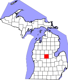 | |
| Villages | ||
| Charter township | ||
| General law townships | ||
| Unincorporated communities | ||
| Indian reservation | ||
| Footnotes | ‡This populated place also has portions in an adjacent county or counties | |