Uni-Trade Stadium
 | |
| Former names | Laredo Ballpark |
|---|---|
| Location |
6320 Sinatra Parkway Laredo, TX 78045 |
| Owner | City of Laredo |
| Operator | Ventura Sports Group[1] |
| Capacity |
6,000 (Baseball) 16,000 (Concerts) |
| Field size |
Left Field: 335 feet Left Center Field: 385 feet Center Field: 405 feet Right Center Field: 385 feet Right Field: 335 feet |
| Surface | TifSport Bermudagrass |
| Construction | |
| Broke ground | June 11, 2011[1] |
| Opened | May 17, 2012 |
| Construction cost | $18 million[2] |
| Architect |
HKS Humphries & Sanchez[1] |
| Structural engineer | Puig Engineering LLC[1] |
| General contractor | Leyendecker Construction[1] |
| Tenants | |
|
Laredo Lemurs (AAIPB) (2012–present) Laredo Roses | |
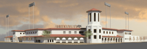
The Uni-Trade Stadium is a baseball stadium in Laredo, Texas. The stadium is home to the Laredo Lemurs, a baseball team in the American Association and the Laredo Roses, a women's full contact American football team in the Sugar N Spice Football League.[3] The stadium is also used for youth soccer leagues, youth and prep baseball games and concerts.[4]
History
The Laredo Ballpark project was first approved by the city council and was voted in favor of (with 61.32% of the votes in favor and 38.68% against) constructing it with money collected by a .25% sales tax increase for the LEC since 2004 of which there is a surplus of about $18 million.[5] The project consisted of building a new multiuse Baseball field near the Laredo Energy Arena (LEA). On December 9, 2011, it was announced that the stadium would be named Uni-Trade Stadium,[6] after Uni-Trade Forwarding LLC, a local freight forwarder. The park opened on May 17, 2012, with the Lemurs defeating the defending American Association champion Grand Prairie AirHogs 5-1 in front of a crowd of 5,923.
Field
The baseball field playing surface was designed and built by sports field contractor Texas Multi-Chem, out of Kerrville, TX. The baseball field's natural grass surface is TifSport hybrid Bermuda and the root zone consists of an 8" layer of USGA sand and Dakota peat. The field also contains an internal drainage system to help avoid rain outs.[7]
References
- 1 2 3 4 5 "The Ballpark at Laredo Breaks Ground Baseball Stadium Should Be Completed by 2012". Laredo Sun. June 11, 2011. Retrieved February 9, 2012.
- ↑ http://www.ballparkdigest.com/features/index.html?article_id=2599,
- ↑ http://www.pro8news.com/news/local/Council-Response-to-Baseball-Stadium-Vote-100406984.html
- ↑ Laredo Morning TImes; Vote Goes Strongly In Favor of Stadium
- ↑ Laredo Morning Times; Webb County Vote Totals
- ↑ "Laredo Lemurs' Baseball Stadium Named". Laredo Sun (Laredo, Texas). December 9, 2011. Retrieved 2011-12-09.
- ↑ "Avoid Rainouts With Internal Drainage Systems". (Texas Multi-Chem - Kerrville, TX). June 1, 2012.
External links
| Attractions and Sports |  | ||||||||||||||
|---|---|---|---|---|---|---|---|---|---|---|---|---|---|---|---|
| Business | |||||||||||||||
| History | |||||||||||||||
| Geography | |||||||||||||||
| Education | |||||||||||||||
| Media |
| ||||||||||||||
| Transportation |
| ||||||||||||||
| Neighborhoods | |||||||||||||||
| Current ballparks in the American Association | ||
|---|---|---|
| North Division | Central Division | South Division |
| CHS Field | CommunityAmerica Ballpark | AirHogs Stadium |
| Newman Outdoor Field | Haymarket Park | The Depot at Cleburne Station |
| Shaw Park | Lewis and Clark Park | Lawrence–Dumont Stadium |
| Sioux Falls Stadium | U.S. Steel Yard | Uni-Trade Stadium |
Coordinates: 27°33′14″N 99°27′20″W / 27.55399°N 99.45544°W