Underhill State Park
| Underhill State Park | |
|---|---|
 | |
| Type | State park |
| Location |
352 Mountain Road Underhill, Vermont |
| Coordinates | 44°31′50″N 72°49′59″W / 44.5305°N 72.8331°WCoordinates: 44°31′50″N 72°49′59″W / 44.5305°N 72.8331°W |
| Operated by | Vermont Department of Forests, Parks, and Recreation |
| Open | Memorial Day Weekend - Mid-October |
| Website | http://www.vtstateparks.com/htm/underhill.htm |
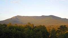
Underhill State Park is a state park in Underhill, Vermont on the west slope of 4,300 feet Mt. Mansfield.[1] It is located in the 39,837-acre Mount Mansfield State Forest.
Activities includes hiking, camping, mountain biking, stream fishing, wildlife watching, and picnicking.[2]
Facilities include 7 lean-to shelters and two tent campsites, a group camping area, restrooms with flush toilets and cold running water.[1] There is a log picnic shelter that was built by the Civilian Conservation Corps in the 1930s.
There are four trails to the summit ridge of Mt. Mansfield from the park. The Sunset Ridge Trail is 3 miles to the summit. The Long Trail traverses the summit ridge.
The park is closed in the winter.
References
- 1 2 "Underhill State Park". Vermont State Parks. Retrieved 21 July 2016.
- ↑ "Underhill State Park". Oh Ranger. Retrieved 23 July 2016.
External links
This article is issued from Wikipedia - version of the 10/19/2016. The text is available under the Creative Commons Attribution/Share Alike but additional terms may apply for the media files.