Hogback Mountain (Vermont)
| Hogback Mountain | |
|---|---|
| Highest point | |
| Elevation | 2,410 ft (730 m) |
| Coordinates | 42°52′01″N 72°47′15″W / 42.8670258°N 72.7875955°WCoordinates: 42°52′01″N 72°47′15″W / 42.8670258°N 72.7875955°W [1] |
| Geography | |
| Location | Marlboro, Windham County, Vermont |
| Parent range | Green Mountains |
| Topo map | Jacksonville |
Hogback Mountain is a mountain in southern Vermont, United States, in the town of Marlboro, Vermont, just north of Vermont Route 9. Its main peak is 2,409 feet (734 m) high. The area is well known for expansive views from Route 9.
The Hogback Mountain Ski Area, which operated from 1946 to 1986, was actually located across Route 9 on Mt Olga.[2] Roughly 590 acres (2.4 km2) was purchased and given to the town of Marlboro as conservation land, known as Hogback Mountain Conservation Area.[2]
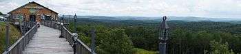
View from Hogback Mountain Gift Shop along Route 9, Vermont, USA
References
- ↑ "Hogback Mountain". Geographic Names Information System. United States Geological Survey. Retrieved 2010-02-26.
- 1 2 hogbackvt.org/
External links
This article is issued from Wikipedia - version of the 8/1/2016. The text is available under the Creative Commons Attribution/Share Alike but additional terms may apply for the media files.