Tyne Tunnel
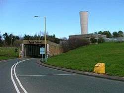

The Tyne Tunnel is the name given to two 2-lane vehicular toll tunnels under the River Tyne in North East England. Completed in 1967 and 2011 respectively, they connect the town of Jarrow on the south bank of the river with North Shields and Howdon on the northern end. The original tunnel was one of three forming the original Tyne Tunnel Project; the others are the pedestrian and cyclist tunnels opened in 1951. The tunnels are 7 miles (11 km) downstream and to the east of Newcastle upon Tyne and form part of the A19 road.
History
A scheme for the construction of a set of three tunnels under the Tyne was put forward by the Durham and Northumberland County Councils in 1937. After prolonged negotiations with the Ministry of Transport, the scheme was approved in 1943. The Tyne Tunnel Act, the legislative instrument necessary to enable the construction of the tunnels, received Royal Assent in 1946. Postwar restrictions on capital expenditure delayed the construction of the vehicular tunnel, but work started on the smaller tunnels for pedestrians and cyclists in 1947.
Tyne cyclist and pedestrian tunnels
 | |
| Overview | |
|---|---|
| Start | Jarrow |
| End | Howdon |
| Operation | |
| Opened | 1951 |
| Owner | North East Combined Authority |
| Operator | TT2 Ltd |
| Traffic | Pedestrian and Cycle |
Tyne Cyclist and Pedestrian Tunnel was Britain's first purpose-built cycling tunnel. It runs under the River Tyne between Howdon and Jarrow, and was opened in 1951, heralded as a contribution to the Festival of Britain.[1] The original cost was £833,000[1] and the tunnel was used by 20,000 people a day.[2] It actually consists of two tunnels running in parallel, one for pedestrian use with a 10 feet 6 inches (3.2 m) diameter, and a larger 12 feet (3.7 m) diameter tunnel for pedal cyclists. Both tunnels are 900 feet (270 m) in length, and lie 40 feet (12.2 m) below the river bed.[1] The tunnels are over 60 years old and are Grade II listed buildings.[3][4]
At each end, the tunnels are connected to surface buildings by two escalators and a lift. The Waygood-Otis escalators have 306 wooden steps each, and are the original models from 1951.[1] At the time of construction, they were the highest single-rise escalators in the UK, with a vertical rise of 85 feet (26 m) and a length of 197 feet (60 m). In 1992. escalators with a higher vertical rise of 90 feet (27.4 m) and 200 feet (61 m) in length were constructed at Angel station on the London Underground. The Tyne Tunnel escalators remain the longest wooden escalators in the world.
In a refitting phase the escalators and lift shafts were due to be upgraded by October 2010 to early 2011 at a cost of £500,000.[5] A £6,000,000 refurbishment was due to take place in 2011.[1]
20,000 people a month use the pedestrian tunnel.[6]
In 2005, The SoundEx filmed a music video to their song Street Freak in the tunnel. The band were permitted to close the cyclist tunnel for two days and use it free of charge to bring the tunnel publicity.
In 2012, contractor GB Building Solutions of Balliol Business Park, Newcastle, was appointed to carry out the £4.9 million refurbishment which will include the replacement of two of the original four escalators with inclined lifts and the replacement of the tunnels’ ageing mechanical and electrical systems.
The two remaining escalators, which are original and of historical significance, will be opened up to public view and illuminated with feature lighting.
New lighting, CCTV, control and communications systems will also be installed, in addition to carrying out repairs to the tunnel structure itself and to the historic finishes within the tunnel such as the tiling and panelling. The concrete floor sections are also to be refurbished or replaced, which will greatly improve the surfaces for cyclists and pedestrians.
Vehicle tunnels
First Tyne motor vehicle tunnel
|
| |
| Overview | |
|---|---|
| Route | A19 |
| Start | Jarrow |
| End | Howdon |
| Operation | |
| Opened | 1967 |
| Owner | North East Combined Authority |
| Operator | TT2 Ltd |
| Traffic | Automotive |
| Toll | £1.70 (Cars) |
| Technical | |
| Number of lanes | 2 |
| Operating speed | 30 mph |
The vehicle tunnel is 1 mile or 5,500 feet (1,700 m) long and has a diameter of 31 ft 3 in (9.5 m) with a roadbed 24 ft (7.3 m). It was built by Edmund Nuttall Limited and was opened by Queen Elizabeth II on 19 October 1967, but commenced operational use only in 1968, on completion of the northern link roads. It was designed to handle 25,000 vehicles per day. The original toll for cars was 2s 6d (12.5p).
Second Tyne motor vehicle tunnel
|
| |
| Overview | |
|---|---|
| Route | A19 |
| Start | Jarrow |
| End | Howdon |
| Operation | |
| Opened | 2011 |
| Owner | North East Combined Authority |
| Operator | TT2 Ltd |
| Traffic | Automotive |
| Toll | £1.70 (Cars) |
| Technical | |
| Number of lanes | 2 |
| Operating speed | 40 mph |
Tunnel usage is forecast to rise to 43,000 per day by 2021. In March 2004 the Tyne and Wear Integrated Transport Authority launched a scheme to build a second, £139 million tunnel. The tunnel is slightly to the east of the existing tunnel, and the pairing allows each tunnel to serve two lanes of traffic, each travelling in the same direction; the original tunnel had two single lanes of traffic in opposing directions, representing an avoidable risk. The UK Government gave the go-ahead for the scheme in July 2005. Construction work started in spring 2008, with the new tunnel opening to two-lane bi-directional traffic on 25 February 2011, at which point the original tunnel closed for a ten-month refurbishment.
The timeline for the new Tyne Tunnel was as follows:
- Transfer tunnels and staff to concessionaire: 1 February 2008
- Main work starts: Spring 2008
- New tunnel opens: end of February 2011
- Existing tunnel closes for refurbishment: end of February 2011
- Both existing and new tunnel fully operational and open: end of November 2011. Originally this was planned for January 2012; however, both refurbishment of the old tunnel was completed earlier than expected and both tunnels were open by lunchtime on 21 November 2011.[7]
The tunnel was constructed under a Private Finance Initiative 30-year "design–build–finance–operate" contract by Bouygues Construction.
Onshore sections of the new tunnel were built using the cut-and-cover method. Under-river sections of the tunnel were prefabricated, floated into position, immersed into a dredged trench, and covered with rocks. By beginning of November 2009, the land approaches to the tunnel had been excavated, and construction of the tunnel, in four 300-foot (90 m) sections, had been completed nearby. The dredger used to excavate the river section of the tunnel cutting arrived on site on 4 November 2009 to excavate 400,000 cubic metres of sediment, which was used to infill the defunct Tyne Dock, reclaiming 13 acres (53,000 m2) of land for use by Port of Tyne.[8] Both ends of the tunnel finally met on 26 May 2010.
Tunnel safety
The new tunnel is fitted with a fixed fire suppression system which releases a fine mist to contain fires to help motorists leave safely and to prevent damage to the tunnel structure. There is also a separate evacuation corridor which runs adjacent to the main tunnel. The old tunnel, now fully refurbished, includes many of the same safety features.
The New Tyne crossing is claimed to be one of the safest in the UK,[7] thanks to a state-of-the-art active fire suppression system which is now included in its design. It is the first in the UK to be fitted with a water mist active fire suppression system, and will further ensure the safety of thousands of people who will travel through it every day.
The original 1960s-built tunnel was slated as of one of the least safe in Europe in 2000, according to a study. Inspectors visited 25 major tunnels around Europe after fire devastated the Mont Blanc Tunnel under the Alps between France and Italy. The Tyne Tunnel was officially rated as "poor" and languished near the bottom of the European league table. The inspectors found it had no automatic fire alarm system, poor lighting, no laybys or hard shoulder, and an emergency walkway that could be reached only by able-bodied people. They also criticised its smoke extraction system. These deficiencies were addressed during the refurbishment of the original road tunnel in 2011.
Tolls
As of 2016, the toll charge for cars is £1.70; vans, trucks, and buses, £3.30.[9] Motorcycles use the tunnel free. A 10% discount is available to Tyne Tunnel permit holders. The permits are passive electronic discs stuck to the inside of the vehicle's windscreen, which are electronically read by the toll booth's scanner, whereupon the toll is debited from the permit-holder's account.[10]
Tunnel is free for blue badge holders.[11]
References
- 1 2 3 4 5 "About The Tunnels". tynepedestrianandcyclisttunnels.co.uk. Retrieved 9 August 2010.
- ↑ "Improvement pledge for pedestrian Tyne Tunnel, Heyday". The Journal. 24 June 2010. Retrieved 9 August 2010.
In their 1950s heyday, the tunnels were used by 20,000 people a day – many of them shipyard and factory workers Now work has started on the repair of the south side lift, which is 25 years old.
- ↑ "New Tyne Tunnel moves a step closer". The Northern Echo. 28 February 2002. Retrieved 31 August 2008.
- ↑ "Improvement pledge for pedestrian Tyne Tunnel, Grade II". The Journal. The Journal. 24 June 2010. Retrieved 9 August 2010.
“However, the tunnels are nearly 60 years old, are Grade II Listed and much of the equipment has now exceeded its designed lifespan.
- ↑ "Improvement pledge for pedestrian Tyne Tunnel, Repair Cost". The Journal. 24 June 2010. Retrieved 9 August 2010.
The lift should be back in operation by October–November, and the process will be repeated on the north side, with a return to use early next year. The lift repairs are expected to cost around £500,000.
- ↑ "FAQs". tynepedestrianandcyclisttunnels.co.uk. 2010. Retrieved 9 August 2010.
Q. How many people use the tunnels? A: Around 20,000 journeys are made per month through the tunnels. That’s around a quarter of a million people every year. It is fairly evenly split between cyclists and pedestrians.
- 1 2 "New Tyne Crossing Web-site". Retrieved 16 January 2012.
- ↑ "Arrival of New Tyne Crossing dredger imminent". Materials Handling World Magazine. 4 November 2009. Archived from the original on 4 November 2009. Retrieved 4 November 2009.
- ↑ "Tyne Tunnel Tolls". TT2 Limited. Retrieved 2016-02-20.
- ↑ "Tyne Tunnel Tolls Prepaid Permits". TT2 Limited. Retrieved 2016-02-20.
- ↑ "Tyne Tunnels Toll Exemption Permits". TT2 Limited. Retrieved 2016-02-20.
- New Civil Engineer - 25 March 2004, pp. 10 & 12.
External links
- TT2 operating and maintaining all four Tyne Tunnels
- Tyne Pedestrian and Cyclist Tunnels
- New Tyne Crossing
- BBC News
| Next vehicle crossing upstream | River Tyne | Next vehicle crossing downstream |
| Tyne Bridge Newcastle upon Tyne (6 miles (10 km)) |
Tyne Tunnel A19 road Grid reference: NZ329660 |
[none] |
| Next pedestrian crossing upstream | River Tyne | Next pedestrian crossing downstream |
| Gateshead Millennium Bridge | Tyne Tunnel Grid reference: NZ329660 |
Shields Ferry |
Coordinates: 54°59′16″N 1°29′08″W / 54.98778°N 1.48556°W