Twentynine Palms Airport
Twentynine Palms Airport (IATA: TNP, ICAO: KTNP, FAA LID: TNP) is a public use airport located six nautical miles (11 km) east of the central business district of Twentynine Palms, a city in San Bernardino County, California, United States. It is owned by the County of San Bernardino.[1]
History
Activated on 1 January 1942 by the United States Army Air Forces. Started as USAAF contract glider training - Twenty-Nine Palms Air Academy until 16 February 1943. Had four axillary airfields in local area. Flying training was performed with Fairchild PT-19s as the primary trainer. Also had several PT-17 Stearmans and a few P-40 Warhawks assigned. Conducted basic flying training from March 1943 until transferred to United States Navy April 1944; Under USN control became an axillary airfield to NAS San Diego.
Facilities and aircraft
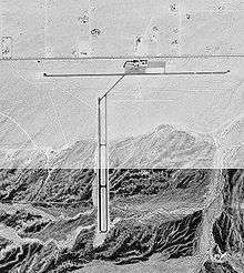
Twentynine Palms Airport covers an area of 480 acres (190 ha) at an elevation of 1,888 feet (575 m) above mean sea level. It has two asphalt paved runways: 8/26 is 5,531 by 75 feet (1,686 x 23 m) and 17/35 is 3,797 by 50 feet (1,157 x 15 m).[1]
For the 12-month period ending February 16, 2006, the airport had 18,000 aircraft operations, an average of 49 per day: 97.% general aviation and 3% military. At that time there were 16 aircraft based at this airport: 68% single-engine, 6% multi-engine and 25% glider.[1]
See also
References
Other sources
-
 This article incorporates public domain material from the Air Force Historical Research Agency website http://www.afhra.af.mil/.
- Shaw, Frederick J. (2004), Locating Air Force Base Sites History’s Legacy, Air Force History and Museums Program, United States Air Force, Washington DC, 2004.
- Manning, Thomas A. (2005), History of Air Education and Training Command, 1942–2002. Office of History and Research, Headquarters, AETC, Randolph AFB, Texas ASIN: B000NYX3PC
External links
|
|---|
|
| Flying Training | | Flying Schools | |
|---|
| | Specialized Schools | |
|---|
| |
|---|
|
| Technical Training | |
|---|